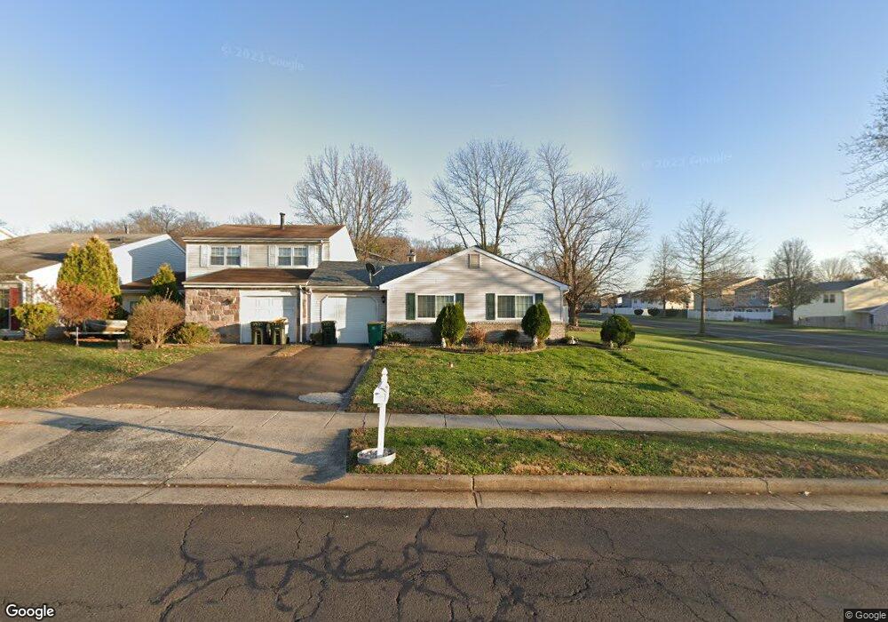
11 Union St Newtown, PA 18940
Estimated Value: $401,000 - $451,000
3
Beds
2
Baths
1,338
Sq Ft
$313/Sq Ft
Est. Value
About This Home
This home is located at 11 Union St, Newtown, PA 18940 and is currently estimated at $418,395, approximately $312 per square foot. 11 Union St is a home located in Bucks County with nearby schools including Goodnoe Elementary School, Newtown Middle School, and Council Rock High School North.
Ownership History
Date
Name
Owned For
Owner Type
Purchase Details
Closed on
Mar 9, 2024
Sold by
Venda and Bonifacio
Bought by
Maria Vendas Trust and Venda
Current Estimated Value
Purchase Details
Closed on
Oct 14, 2005
Sold by
Vandeventer Thomas
Bought by
Venda Bonifacio and Venda Maria
Purchase Details
Closed on
Oct 31, 1997
Sold by
Malloy Michael P and Gaffney Kathleen J
Bought by
Oelschlegal Mark C
Home Financials for this Owner
Home Financials are based on the most recent Mortgage that was taken out on this home.
Original Mortgage
$116,500
Interest Rate
7.19%
Mortgage Type
FHA
Create a Home Valuation Report for This Property
The Home Valuation Report is an in-depth analysis detailing your home's value as well as a comparison with similar homes in the area
Home Values in the Area
Average Home Value in this Area
Purchase History
| Date | Buyer | Sale Price | Title Company |
|---|---|---|---|
| Maria Vendas Trust | -- | None Listed On Document | |
| Venda Bonifacio | $228,000 | Lawyers Title Insurance Co | |
| Oelschlegal Mark C | $117,000 | -- |
Source: Public Records
Mortgage History
| Date | Status | Borrower | Loan Amount |
|---|---|---|---|
| Previous Owner | Oelschlegal Mark C | $116,500 |
Source: Public Records
Tax History Compared to Growth
Tax History
| Year | Tax Paid | Tax Assessment Tax Assessment Total Assessment is a certain percentage of the fair market value that is determined by local assessors to be the total taxable value of land and additions on the property. | Land | Improvement |
|---|---|---|---|---|
| 2025 | $4,265 | $24,000 | $4,000 | $20,000 |
| 2024 | $4,265 | $24,000 | $4,000 | $20,000 |
| 2023 | $4,081 | $24,000 | $4,000 | $20,000 |
| 2022 | $4,002 | $24,000 | $4,000 | $20,000 |
| 2021 | $3,940 | $24,000 | $4,000 | $20,000 |
| 2020 | $3,750 | $24,000 | $4,000 | $20,000 |
| 2019 | $3,661 | $24,000 | $4,000 | $20,000 |
| 2018 | $3,592 | $24,000 | $4,000 | $20,000 |
| 2017 | $3,467 | $24,000 | $4,000 | $20,000 |
| 2016 | $3,443 | $24,000 | $4,000 | $20,000 |
| 2015 | -- | $24,000 | $4,000 | $20,000 |
| 2014 | -- | $24,000 | $4,000 | $20,000 |
Source: Public Records
Map
Nearby Homes
- 164 Commonwealth Dr
- 163 Leedom Way Unit 25
- 323 Leedom Way Unit 56
- 23 Ardsley Ct
- 104 Cornell Rd
- 13 S Lancaster Ln
- 14 Pinetree Ct
- 1011 Diamond Dr Unit 1011
- 231 Sydney Rd
- 226 Court St
- 440 S State St Unit D3
- 221 Parkview Way
- 227 Parkview Way
- 19 Seton Hill Ct
- 4016 Barry Ct Unit 736B
- 15 E Park Rd
- 113 Thorton Ln
- 1206 Barry Ct Unit 717A
- 2010 Barry Ct Unit 743B
- 22 Penn St
- 21 Union St
- 31 Union St
- 206 Commonwealth Dr
- 208 Commonwealth Dr
- 41 Union St
- 210 Commonwealth Dr
- 10 Union St
- 212 Commonwealth Dr
- 20 Union St
- 28 Chesapeake Dr
- 30 Union St
- 102 Chesapeake Dr
- 24 Chesapeake Dr
- 26 Chesapeake Dr
- 205 Commonwealth Dr
- 104 Chesapeake Dr
- 40 Union St
- 106 Chesapeake Dr
- 201 Commonwealth Dr
- 22 Chesapeake Dr