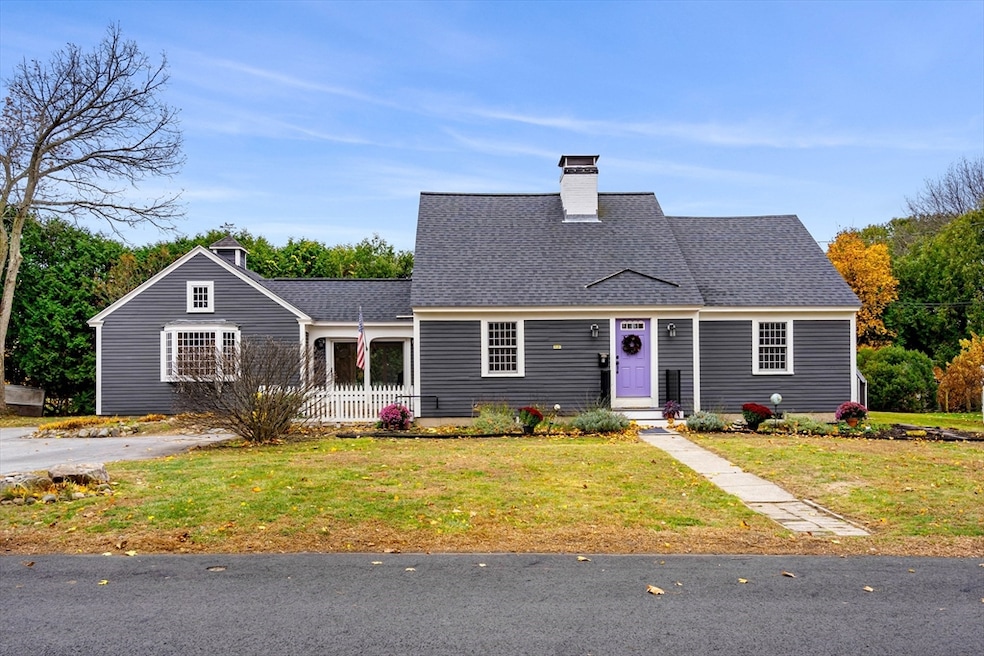
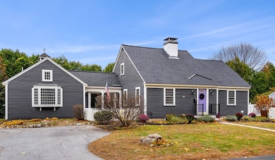
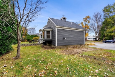
11 W Bradstreet Rd North Andover, MA 01845
Estimated payment $5,189/month
Highlights
- Popular Property
- Open Floorplan
- Cape Cod Architecture
- North Andover High School Rated A-
- Custom Closet System
- Dining Room with Fireplace
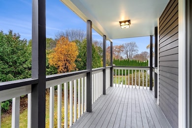
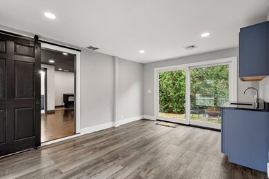
About This Home
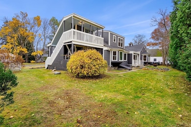
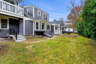
If you love North Andover's Library area and Patriots Park you will love this house! Beautiful recently remodeled home from top to bottom with neutral colors, hardwood floors, new fully appliance kitchens and updated bathrooms. Cozy 2 wood burning fireplaces one in the living room, one upstairs, most rooms have hardwood floors. Second floor bedroom has slider to deck where you can sit and enjoy your morning coffee. Newer heating system, hot water, electrical panel, and central air. Fantastic location views of the Olmstead designed Patriots Park, close to schools, commuter routes, Youth Center, Senior Center, restaurants, museum, coffee shops, playgrounds, trains and bus transportation nearby. This is not just a lovely home but a lifestyle with possibilities of a 2 family or in-law and added rental income! 2 sets of washer & dryers included. *Property has Certified Deleaded Certificate forth coming prior to the closing.
Home Details
Home Type
- Single Family
Est. Annual Taxes
- $7,203
Year Built
- Built in 1950 | Remodeled
Lot Details
- 0.25 Acre Lot
- Level Lot
- Irregular Lot
- Property is zoned R4
Home Design
- Cape Cod Architecture
- Frame Construction
- Shingle Roof
- Concrete Perimeter Foundation
Interior Spaces
- 2,505 Sq Ft Home
- Open Floorplan
- Wet Bar
- Crown Molding
- Insulated Windows
- Bay Window
- Living Room with Fireplace
- Dining Room with Fireplace
- 2 Fireplaces
Kitchen
- Range
- ENERGY STAR Qualified Refrigerator
- ENERGY STAR Qualified Dishwasher
- Disposal
Flooring
- Wood
- Tile
Bedrooms and Bathrooms
- 4 Bedrooms
- Primary Bedroom on Main
- Custom Closet System
- Linen Closet
- Walk-In Closet
- 3 Full Bathrooms
Laundry
- ENERGY STAR Qualified Dryer
- Dryer
- ENERGY STAR Qualified Washer
Unfinished Basement
- Basement Fills Entire Space Under The House
- Interior and Exterior Basement Entry
- Sump Pump
- Block Basement Construction
- Laundry in Basement
Parking
- 5 Car Parking Spaces
- Paved Parking
- Open Parking
- Off-Street Parking
Outdoor Features
- Bulkhead
- Balcony
Location
- Property is near public transit
- Property is near schools
Schools
- Atkinson Elementary School
- N. Andover Middle School
- North Andover High School
Utilities
- Central Heating and Cooling System
- 3 Cooling Zones
- 3 Heating Zones
- Heating System Uses Natural Gas
- Pellet Stove burns compressed wood to generate heat
- High Speed Internet
Listing and Financial Details
- Assessor Parcel Number M:00032 B:00043 L:00000
Community Details
Overview
- No Home Owners Association
- Library & Patriots Park Area Subdivision
Amenities
- Shops
Recreation
- Park
- Jogging Path
Map
Home Values in the Area
Average Home Value in this Area
Tax History
| Year | Tax Paid | Tax Assessment Tax Assessment Total Assessment is a certain percentage of the fair market value that is determined by local assessors to be the total taxable value of land and additions on the property. | Land | Improvement |
|---|---|---|---|---|
| 2025 | $7,203 | $639,700 | $336,700 | $303,000 |
| 2024 | $6,801 | $613,300 | $319,000 | $294,300 |
| 2023 | $6,403 | $523,100 | $269,400 | $253,700 |
| 2022 | $6,320 | $467,100 | $244,600 | $222,500 |
| 2021 | $6,291 | $444,000 | $221,500 | $222,500 |
| 2020 | $5,980 | $435,200 | $221,500 | $213,700 |
| 2019 | $5,836 | $435,200 | $221,500 | $213,700 |
| 2018 | $7,197 | $495,300 | $221,500 | $273,800 |
| 2017 | $5,543 | $388,200 | $181,900 | $206,300 |
| 2016 | $5,544 | $388,500 | $180,800 | $207,700 |
| 2015 | $5,982 | $415,700 | $174,500 | $241,200 |
Property History
| Date | Event | Price | List to Sale | Price per Sq Ft |
|---|---|---|---|---|
| 11/21/2025 11/21/25 | For Sale | $875,000 | -- | $349 / Sq Ft |
Purchase History
| Date | Type | Sale Price | Title Company |
|---|---|---|---|
| Quit Claim Deed | -- | None Available | |
| Deed | -- | -- |
Mortgage History
| Date | Status | Loan Amount | Loan Type |
|---|---|---|---|
| Previous Owner | $110,000 | Stand Alone Second | |
| Previous Owner | $10,000 | No Value Available |
Source: MLS Property Information Network (MLS PIN)
MLS Number: 73457213
APN: NAND-000320-000043
Disclaimer: Certain information contained herein is derived from information provided by parties other than Homes.com. All information provided is deemed reliable, but is not guaranteed to be accurate and should be independently verified.
![]() The property listing data and information, or the Images, set forth herein were provided to MLS Property Information Network, Inc. from third party sources, including sellers, lessors and public records, and were compiled by MLS Property Information Network, Inc. The property listing data and information, and the Images, are for the personal, non-commercial use of consumers having a good faith interest in purchasing or leasing listed properties of the type displayed to them and may not be used for any purpose other than to identify prospective properties which such consumers may have a good faith interest in purchasing or leasing. MLS Property Information Network, Inc. and its subscribers disclaim any and all representations and warranties as to the accuracy of the property listing data and information, or as to the accuracy of any of the Images, set forth herein.
The property listing data and information, or the Images, set forth herein were provided to MLS Property Information Network, Inc. from third party sources, including sellers, lessors and public records, and were compiled by MLS Property Information Network, Inc. The property listing data and information, and the Images, are for the personal, non-commercial use of consumers having a good faith interest in purchasing or leasing listed properties of the type displayed to them and may not be used for any purpose other than to identify prospective properties which such consumers may have a good faith interest in purchasing or leasing. MLS Property Information Network, Inc. and its subscribers disclaim any and all representations and warranties as to the accuracy of the property listing data and information, or as to the accuracy of any of the Images, set forth herein.
- 168 Greene St
- 387 Massachusetts Ave
- 8 Little Rd
- 33 Herrick Rd
- 416 Waverley Rd
- 64 2nd St
- 177 & 183 Massachusetts Ave
- 19 Fernview Ave Unit 6
- 19 Fernview Ave Unit 5
- 90 Edgelawn Ave Unit 1
- 35 Fernview Ave Unit 5
- 16 Court St
- 148 Main St Unit A508
- 148 Main St Unit C538
- 148 Main St Unit A307
- 127 Marblehead St Unit A
- 25 Fernview Ave Unit 8
- 23 Fernview Ave Unit 1
- 52 Fernview Ave Unit 7
- 12 Walker Rd Unit 6
- 244 Main St Unit 2
- 244 Main St Unit Second Floor
- 244 Main St Unit 1
- 244 Main St Unit First Floor
- 73 Davis St Unit B
- 16 Lincoln St Unit 16
- 95 2nd St Unit 95-97 Second St. Unit 97
- 11 2nd St Unit 1
- 34 Camden St Unit 34
- 10 Beacon Hill Blvd Unit 10 Beacon Hill Blvd.
- 1 Walker Rd Unit 1
- 1 Walker Rd Unit 3
- 67 Fernview Ave Unit 2
- 9 Walker Rd Unit 4
- 3 Walker Rd Unit 1
- 90 Edgelawn Ave Unit 1
- 35 Fernview Ave Unit 5
- 148 Main St Unit A310
- 64-66 Waverly Rd Unit 3
- 93 Main St Unit 3
