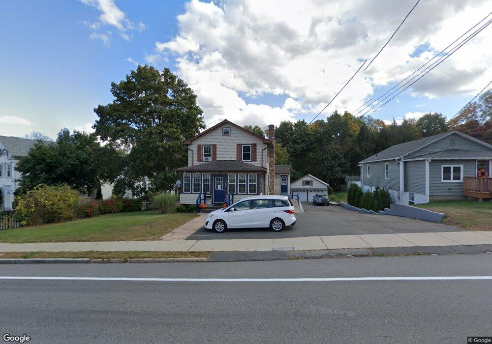
11 W High St East Hampton, CT 06424
Estimated Value: $191,221
3
Beds
1
Bath
1,338
Sq Ft
$143/Sq Ft
Est. Value
About This Home
This home is located at 11 W High St, East Hampton, CT 06424 and is currently estimated at $191,221, approximately $142 per square foot. 11 W High St is a home located in Middlesex County with nearby schools including Memorial School, Center Elementary School, and East Hampton Middle School.
Ownership History
Date
Name
Owned For
Owner Type
Purchase Details
Closed on
Jul 13, 2009
Sold by
Chery Chase Bk
Bought by
Serra Raymond J and Serra Heidi L
Current Estimated Value
Purchase Details
Closed on
Dec 9, 1987
Sold by
Rinell Timothy A
Bought by
Yeager Zema O
Purchase Details
Closed on
Jun 22, 1987
Sold by
Clark George
Bought by
Rinell Timothy A
Create a Home Valuation Report for This Property
The Home Valuation Report is an in-depth analysis detailing your home's value as well as a comparison with similar homes in the area
Home Values in the Area
Average Home Value in this Area
Purchase History
| Date | Buyer | Sale Price | Title Company |
|---|---|---|---|
| Serra Raymond J | $114,900 | -- | |
| Serra Raymond J | $114,900 | -- | |
| Yeager Zema O | $159,000 | -- | |
| Rinell Timothy A | $155,000 | -- |
Source: Public Records
Mortgage History
| Date | Status | Borrower | Loan Amount |
|---|---|---|---|
| Open | Rinell Timothy A | $172,500 | |
| Previous Owner | Rinell Timothy A | $192,000 |
Source: Public Records
Tax History
| Year | Tax Paid | Tax Assessment Tax Assessment Total Assessment is a certain percentage of the fair market value that is determined by local assessors to be the total taxable value of land and additions on the property. | Land | Improvement |
|---|---|---|---|---|
| 2025 | $7,365 | $185,460 | $73,240 | $112,220 |
| 2024 | $7,055 | $185,460 | $73,240 | $112,220 |
| 2023 | $6,688 | $185,460 | $73,240 | $112,220 |
| 2022 | $6,428 | $185,460 | $73,240 | $112,220 |
| 2021 | $6,404 | $185,460 | $73,240 | $112,220 |
| 2020 | $5,858 | $176,780 | $73,240 | $103,540 |
| 2019 | $5,399 | $162,920 | $73,240 | $89,680 |
| 2018 | $5,103 | $162,920 | $73,240 | $89,680 |
| 2017 | $5,103 | $162,920 | $73,240 | $89,680 |
| 2016 | $4,796 | $162,920 | $73,240 | $89,680 |
| 2015 | $4,534 | $163,200 | $72,400 | $90,800 |
| 2014 | $3,945 | $163,200 | $72,400 | $90,800 |
Source: Public Records
Map
Nearby Homes
- 14 Main St
- 24 N Main St
- 1 Watrous St
- 4 Watrous St
- 43 E High St
- 29 Watrous St
- 95 Tarragon Dr
- 18 Lake Blvd
- 30 Barbara Ave
- 27 Edgerton St
- 104 Lake Vista Dr Unit 104
- 15 Waterview Cir
- 3 Young St
- 141 E High St
- 0002-6 Edgewater Cir
- 0002-7 Edgewater Cir
- 0002-5 Edgewater Cir
- 00023 Edgewater Cir
- 0002-3 Edgewater Cir
- 00025 Edgewater Cir
Your Personal Tour Guide
Ask me questions while you tour the home.