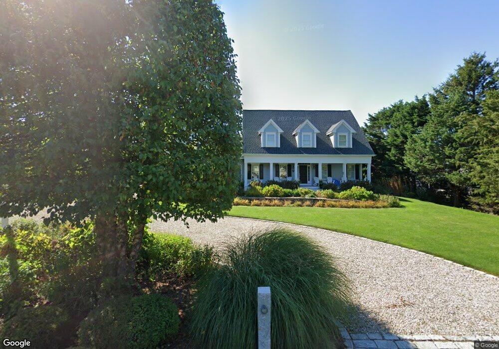
11 Wades Way Dennis, MA 02638
Dennis Village NeighborhoodEstimated Value: $2,147,000 - $3,490,000
4
Beds
4
Baths
2,745
Sq Ft
$985/Sq Ft
Est. Value
About This Home
This home is located at 11 Wades Way, Dennis, MA 02638 and is currently estimated at $2,703,190, approximately $984 per square foot. 11 Wades Way is a home located in Barnstable County with nearby schools including Dennis-Yarmouth Regional High School.
Ownership History
Date
Name
Owned For
Owner Type
Purchase Details
Closed on
Apr 12, 2016
Sold by
Ryan Daniel J and Ryan Patricia A
Bought by
Patricia A Ryan Ft
Current Estimated Value
Purchase Details
Closed on
Oct 3, 2012
Sold by
Sutherland Carla and Tzortzakis Margarita
Bought by
Ryan Daniel J and Ryan Patricia A
Purchase Details
Closed on
May 22, 2006
Sold by
Antonelli Ida
Bought by
Sutherland Carla and Tzortzakis Margarita
Create a Home Valuation Report for This Property
The Home Valuation Report is an in-depth analysis detailing your home's value as well as a comparison with similar homes in the area
Home Values in the Area
Average Home Value in this Area
Purchase History
| Date | Buyer | Sale Price | Title Company |
|---|---|---|---|
| Patricia A Ryan Ft | -- | -- | |
| Ryan Daniel J | $665,000 | -- | |
| Sutherland Carla | -- | -- |
Source: Public Records
Tax History Compared to Growth
Tax History
| Year | Tax Paid | Tax Assessment Tax Assessment Total Assessment is a certain percentage of the fair market value that is determined by local assessors to be the total taxable value of land and additions on the property. | Land | Improvement |
|---|---|---|---|---|
| 2025 | $10,289 | $2,376,300 | $915,700 | $1,460,600 |
| 2024 | $10,093 | $2,299,200 | $880,600 | $1,418,600 |
| 2023 | $9,258 | $1,982,500 | $692,800 | $1,289,700 |
| 2022 | $8,841 | $1,578,700 | $624,100 | $954,600 |
| 2021 | $8,352 | $1,385,100 | $611,800 | $773,300 |
| 2020 | $8,657 | $1,419,100 | $584,600 | $834,500 |
| 2019 | $7,548 | $1,223,400 | $479,900 | $743,500 |
| 2018 | $7,342 | $1,158,100 | $456,800 | $701,300 |
| 2017 | $7,122 | $1,158,100 | $456,800 | $701,300 |
| 2016 | $6,753 | $1,034,100 | $456,800 | $577,300 |
| 2015 | $6,618 | $1,034,100 | $456,800 | $577,300 |
| 2014 | $6,392 | $1,006,600 | $387,000 | $619,600 |
Source: Public Records
Map
Nearby Homes
- 69 Horsefoot Path
- 7 Collins Ave
- 18 Donovan Way
- 49 Rodoalph's Way
- 4 Spadoni Rd
- 4 Spadoni Way
- 12 Dunes View Rd
- 25 Horsefoot Path
- 13 Hippogriffe Rd
- 96 Shore Dr
- 1 Johnson Ln
- 37 Johnson Ln
- 7 Dolphin Way
- 73 Pilgrim Rd
- 9 Bayberry Ln
- 84 Hiram Pond Rd
- 59 Hope Ln
- 19 Deacon Joseph Ln
- 645 Main St Back Lot
- 15 Signal Hill Dr
- 6 Mandigo Rd
- 7 Wades Way
- 5 Wades Way
- 7 Uncle Johns Way
- 11 Uncle Johns Way
- 12 O K Ave
- 27 Uncle Johns Way
- 3 Uncle Johns Way
- 15 Uncle Johns Way
- 15 Uncle Johns Way
- 10 Wades Way
- 12 Karl Ln Unit O
- 2 Mandigo Rd
- 14 O K Ave
- 4 Mandigo Rd
- 12 Wades Way
- 18 Wades Way
- 17 Uncle Johns Way
- 37A Uncle Johns Way
- 39 Uncle Johns Way