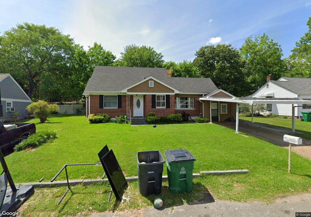
11 Wando Dr Chattanooga, TN 37412
Estimated Value: $226,000 - $262,669
Studio
--
Bath
1,266
Sq Ft
$195/Sq Ft
Est. Value
About This Home
This home is located at 11 Wando Dr, Chattanooga, TN 37412 and is currently estimated at $247,167, approximately $195 per square foot. 11 Wando Dr is a home located in Hamilton County with nearby schools including East Ridge Elementary School, East Ridge Middle School, and East Ridge High School.
Ownership History
Date
Name
Owned For
Owner Type
Purchase Details
Closed on
Aug 10, 2016
Sold by
Gft Property Investments Llc
Bought by
Kimsey Frank and Kimsey Jodi
Current Estimated Value
Purchase Details
Closed on
Jul 26, 2015
Sold by
Grant Monica D and Grant Kirk A
Bought by
Gft Property Investments Llc
Purchase Details
Closed on
Apr 1, 2013
Sold by
Grant Kirk A
Bought by
Grant Monica D
Purchase Details
Closed on
Mar 31, 2000
Sold by
Marvin Trantham Bruce and Rogers Denise Rogers
Bought by
Grant Kirk A and Grant Monica D
Home Financials for this Owner
Home Financials are based on the most recent Mortgage that was taken out on this home.
Original Mortgage
$69,150
Interest Rate
8.38%
Mortgage Type
FHA
Create a Home Valuation Report for This Property
The Home Valuation Report is an in-depth analysis detailing your home's value as well as a comparison with similar homes in the area
Home Values in the Area
Average Home Value in this Area
Purchase History
| Date | Buyer | Sale Price | Title Company |
|---|---|---|---|
| Kimsey Frank | $90,500 | None Available | |
| Gft Property Investments Llc | $79,435 | None Available | |
| Grant Monica D | -- | Prior Title | |
| Grant Kirk A | $69,750 | Title Escrow Chattanooga Inc |
Source: Public Records
Mortgage History
| Date | Status | Borrower | Loan Amount |
|---|---|---|---|
| Previous Owner | Grant Kirk A | $69,150 |
Source: Public Records
Tax History
| Year | Tax Paid | Tax Assessment Tax Assessment Total Assessment is a certain percentage of the fair market value that is determined by local assessors to be the total taxable value of land and additions on the property. | Land | Improvement |
|---|---|---|---|---|
| 2025 | $994 | $65,600 | $0 | $0 |
| 2024 | $789 | $35,275 | $0 | $0 |
| 2023 | $1,239 | $35,275 | $0 | $0 |
| 2022 | $1,239 | $35,275 | $0 | $0 |
| 2021 | $1,419 | $35,275 | $0 | $0 |
| 2020 | $1,117 | $22,625 | $0 | $0 |
| 2019 | $1,117 | $22,625 | $0 | $0 |
| 2018 | $1,117 | $22,625 | $0 | $0 |
| 2017 | $1,117 | $22,625 | $0 | $0 |
| 2016 | $1,098 | $0 | $0 | $0 |
| 2015 | $1,098 | $21,700 | $0 | $0 |
| 2014 | $1,098 | $0 | $0 | $0 |
Source: Public Records
Map
Nearby Homes
- 603 Marlboro Ave
- 4800 Madonna Ave
- 414 Haney Dr
- 403 Haney Dr
- 306 Asbury Dr
- 615 S Moore Rd
- 905 Blue Heights Dr
- 909 Blue Heights Dr
- 905 Blue Heights Dr Unit 19
- 909 Blue Heights Dr Unit 17
- 719 Belvoir Ave
- 703 Belvoir Ave
- 529 S Saint Marks Ave
- 215 S Lovell Ave
- 123 S Moore Rd
- 520 Bacon Trail
- 207 S Lovell Ave
- 4248 Kenton Dr
- 724 Bacon Trail Unit 51
- 724 Bacon Trail
Your Personal Tour Guide
Ask me questions while you tour the home.