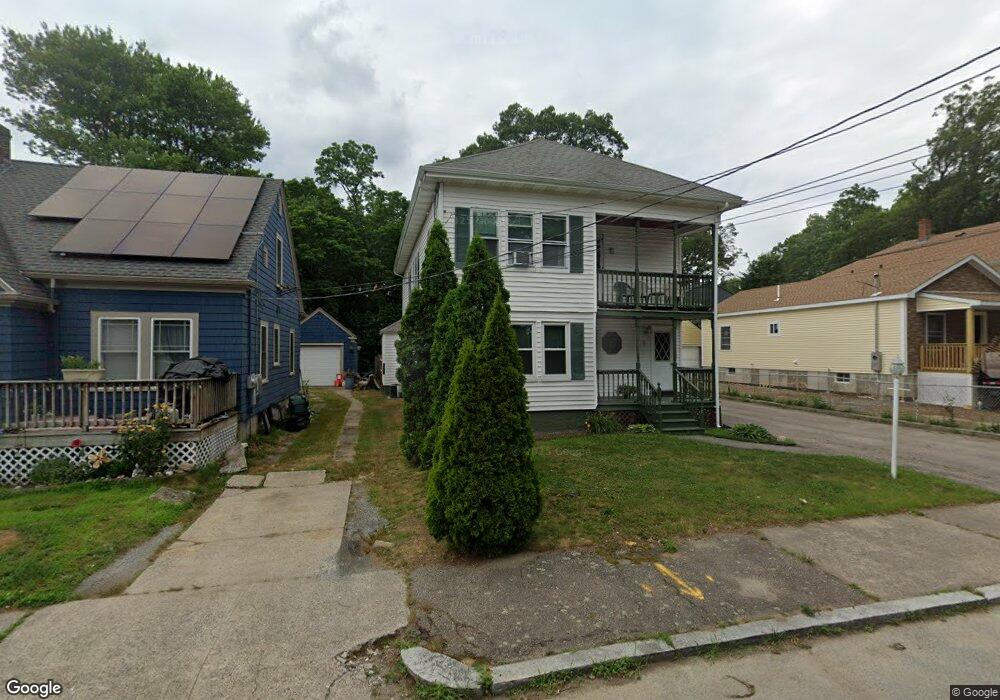
11 Westminster Ave Attleboro, MA 02703
Estimated Value: $541,000 - $648,000
5
Beds
3
Baths
2,572
Sq Ft
$237/Sq Ft
Est. Value
About This Home
This home is located at 11 Westminster Ave, Attleboro, MA 02703 and is currently estimated at $608,857, approximately $236 per square foot. 11 Westminster Ave is a home located in Bristol County with nearby schools including Hill-Roberts Elementary School, Robert J. Coelho Middle School, and Attleboro High School.
Ownership History
Date
Name
Owned For
Owner Type
Purchase Details
Closed on
Dec 7, 1998
Sold by
Lyons Paul H and Lyons Blanche M
Bought by
Malek Elizabeth
Current Estimated Value
Home Financials for this Owner
Home Financials are based on the most recent Mortgage that was taken out on this home.
Original Mortgage
$116,000
Outstanding Balance
$26,122
Interest Rate
6.68%
Mortgage Type
Purchase Money Mortgage
Estimated Equity
$582,735
Create a Home Valuation Report for This Property
The Home Valuation Report is an in-depth analysis detailing your home's value as well as a comparison with similar homes in the area
Home Values in the Area
Average Home Value in this Area
Purchase History
| Date | Buyer | Sale Price | Title Company |
|---|---|---|---|
| Malek Elizabeth | $145,000 | -- |
Source: Public Records
Mortgage History
| Date | Status | Borrower | Loan Amount |
|---|---|---|---|
| Open | Malek Elizabeth | $116,000 | |
| Previous Owner | Malek Elizabeth | $11,700 | |
| Previous Owner | Malek Elizabeth | $100,000 |
Source: Public Records
Tax History
| Year | Tax Paid | Tax Assessment Tax Assessment Total Assessment is a certain percentage of the fair market value that is determined by local assessors to be the total taxable value of land and additions on the property. | Land | Improvement |
|---|---|---|---|---|
| 2025 | $5,699 | $454,100 | $111,200 | $342,900 |
| 2024 | $5,522 | $433,800 | $111,200 | $322,600 |
| 2023 | $4,942 | $361,000 | $101,100 | $259,900 |
| 2022 | $4,547 | $314,700 | $96,300 | $218,400 |
| 2021 | $4,468 | $301,900 | $92,500 | $209,400 |
| 2020 | $4,189 | $287,700 | $89,800 | $197,900 |
| 2019 | $4,607 | $280,100 | $88,100 | $192,000 |
| 2018 | $8 | $246,700 | $85,500 | $161,200 |
| 2017 | $4,617 | $249,100 | $85,500 | $163,600 |
| 2016 | $3,287 | $221,800 | $83,900 | $137,900 |
| 2015 | $3,104 | $211,000 | $83,900 | $127,100 |
| 2014 | $2,882 | $194,100 | $79,900 | $114,200 |
Source: Public Records
Map
Nearby Homes
- 18 Newton St
- 54 Baltic St Unit 54
- 52 Baltic St Unit 52
- 58 Baltic St Unit 58
- 56 Baltic St Unit 56
- 61 Mendon Rd
- 91 Greenwich St
- 50 Pullman Ave Unit A
- 50 Pullman Ave Unit B
- 67 Norton St
- 37 Turner St
- 79 Turner St
- 338 Mendon Rd
- 386 Mendon Ave
- 195 Brown St
- 460 Collins St Unit 6
- 460 Collins St Unit 9
- 82 Belair Ave
- 27 Collins Ave
- 735 Broadway
- 11 Westminster Ave Unit 2
- 15 Westminster Ave
- 5 Westminster Ave
- 17 Westminster Ave
- 208 Mendon Rd
- 31 Westminster Ave
- 201 Mendon Rd
- 223 Mendon Rd
- 223 Mendon Rd Unit B
- 223 Mendon Rd Unit A
- 223 Mendon Rd Unit 2
- 223 Mendon Rd Unit 1
- 214 Mendon Rd Unit 216
- 79 Allenson Ave
- 39 Westminster Ave
- 456 Robinson Ave
- 222 Mendon Rd
- 220 Mendon Rd
- 220 Mendon Rd Unit 220
- 931 Washington St
Your Personal Tour Guide
Ask me questions while you tour the home.