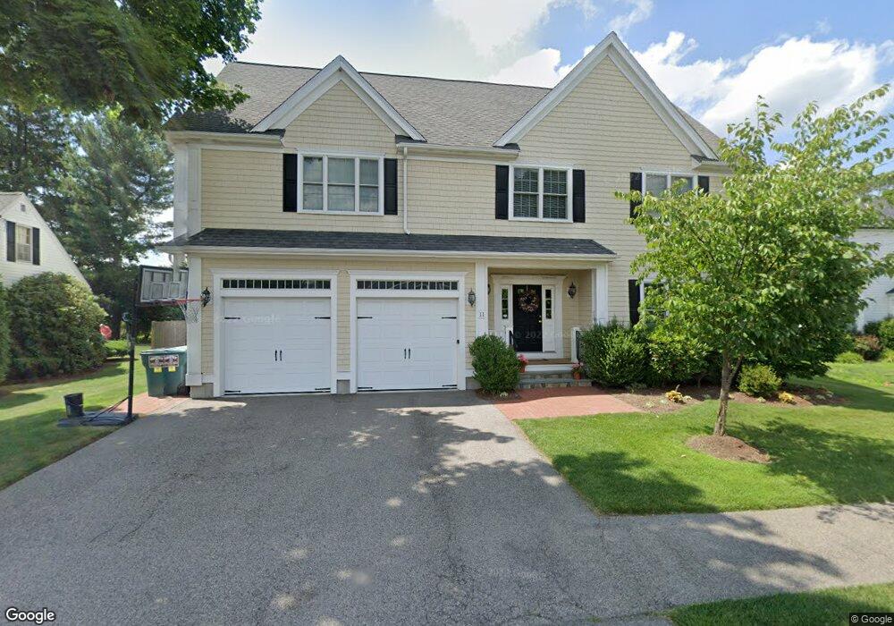
11 Whiting Way Needham, MA 02492
Estimated Value: $2,022,636 - $2,422,000
6
Beds
5
Baths
5,300
Sq Ft
$421/Sq Ft
Est. Value
About This Home
This home is located at 11 Whiting Way, Needham, MA 02492 and is currently estimated at $2,231,409, approximately $421 per square foot. 11 Whiting Way is a home located in Norfolk County with nearby schools including Newman Elementary School, High Rock Middle School, and Pollard Middle School.
Ownership History
Date
Name
Owned For
Owner Type
Purchase Details
Closed on
May 26, 2011
Sold by
C&C Builders Llc
Bought by
Slatkavitz Kevin and Slatkavitz Christine A
Current Estimated Value
Home Financials for this Owner
Home Financials are based on the most recent Mortgage that was taken out on this home.
Original Mortgage
$720,000
Outstanding Balance
$503,513
Interest Rate
4.94%
Mortgage Type
Purchase Money Mortgage
Estimated Equity
$1,727,896
Purchase Details
Closed on
Apr 20, 2005
Sold by
Whiting 11 Way Rt and Axt William J
Bought by
C&C Builders Llc
Create a Home Valuation Report for This Property
The Home Valuation Report is an in-depth analysis detailing your home's value as well as a comparison with similar homes in the area
Home Values in the Area
Average Home Value in this Area
Purchase History
| Date | Buyer | Sale Price | Title Company |
|---|---|---|---|
| Slatkavitz Kevin | $1,190,000 | -- | |
| C&C Builders Llc | $495,000 | -- |
Source: Public Records
Mortgage History
| Date | Status | Borrower | Loan Amount |
|---|---|---|---|
| Open | Slatkavitz Kevin | $720,000 |
Source: Public Records
Tax History Compared to Growth
Tax History
| Year | Tax Paid | Tax Assessment Tax Assessment Total Assessment is a certain percentage of the fair market value that is determined by local assessors to be the total taxable value of land and additions on the property. | Land | Improvement |
|---|---|---|---|---|
| 2025 | $19,799 | $1,867,800 | $779,900 | $1,087,900 |
| 2024 | $21,854 | $1,745,500 | $562,700 | $1,182,800 |
| 2023 | $21,395 | $1,640,700 | $562,700 | $1,078,000 |
| 2022 | $20,483 | $1,532,000 | $502,300 | $1,029,700 |
| 2021 | $19,962 | $1,532,000 | $502,300 | $1,029,700 |
| 2020 | $18,638 | $1,492,200 | $502,700 | $989,500 |
| 2019 | $17,771 | $1,434,300 | $457,000 | $977,300 |
| 2018 | $17,039 | $1,434,300 | $457,000 | $977,300 |
| 2017 | $15,519 | $1,305,200 | $457,000 | $848,200 |
| 2016 | $15,062 | $1,305,200 | $457,000 | $848,200 |
| 2015 | $14,736 | $1,305,200 | $457,000 | $848,200 |
| 2014 | $14,077 | $1,209,400 | $397,400 | $812,000 |
Source: Public Records
Map
Nearby Homes
- 98 Great Plain Ave
- 29 Tolman St
- 34 Pershing Rd
- 46 Lincoln Rd
- 93 Seaver St
- 94 Rice St
- 37 Carleton Dr
- 32 Twitchell St
- 100 Rosemary Way Unit 129
- 100 Rosemary Way Unit 324
- 14 Twitchell St
- 9 Hampden St
- 78 Pheasant Landing Rd
- 193 Garden St
- 445 Hillside Ave
- 28 Clovelly Rd
- 35 Andrea Cir
- 98 Hunnewell St
- 24 Deerfield Rd
- 17 Atwood St
- 17 Whiting Way
- 5 Whiting Way
- 16 Mayflower Rd
- 1744 Great Plain Ave
- 10 Mayflower Rd
- 8 Whiting Way
- 25 Whiting Way
- 20 Whiting Way
- 1746 Great Plain Ave
- 1746 Great Plain Ave
- 22 Mayflower Rd
- 1708 Great Plain Ave
- 28 Whiting Way
- 31 Whiting Way
- 30 Mayflower Rd
- 8 Curtis Rd
- 14 Curtis Rd Unit 2
- 14 Curtis Rd
- 1725 Great Plain Ave
- 1700 Great Plain Ave