


11 Wild Aster Ln Brunswick, ME 04011
Estimated payment $13,292/month
Highlights
- 300 Feet of Waterfront
- Docks
- Barn
- Brunswick Jr High School Rated A-
- Access to Tidal Water
- 2.05 Acre Lot
About This Home
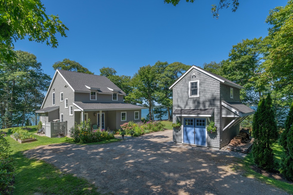
Welcome to Wild Aster, a year-round retreat perched on the shores of Maquoit Bay in Brunswick's coveted Mere Point community. Thoughtfully designed by Maine architect David Matero and built in 2014, this Maine coastal home blends relaxed coastal living with modern comfort. With 300± feet of private shorefront, a gently sloping lawn leads to a quiet beach and dock, perfect for kayaking, swimming, or simply soaking in the salt air. The home offers warm, inviting spaces including a living room anchored by a stone fireplace, a three-season sunroom that captures the ocean breeze, and a cozy loft known as ''The Nest'' for overflow guests or quiet naps. Two and a half baths, all beautifully appointed, provide plenty of space for hosting. Southwesterly views bathe the home in golden afternoon light, with unforgettable sunsets over the bay as your nightly backdrop. Outside, native plantings and thoughtful landscaping preserve the natural character of the 2+ acres, creating a private, peaceful setting. A detached one-car garage with storage above, and a charming two-story insulated studio with electricity, ready for future guest quarters, art space, or a home office offer flexibility and potential.
Located just minutes from downtown Brunswick and Bowdoin College, Wild Aster feels worlds away while still enjoying easy access to fine dining, theater, shopping, and Amtrak service. Whether you're seeking a serene vacation home or a full-time coastal lifestyle, this special place invites you to slow down and savor life by the ocean.
Home Details
Home Type
- Single Family
Est. Annual Taxes
- $12,385
Year Built
- Built in 2014
Lot Details
- 2.05 Acre Lot
- 300 Feet of Waterfront
- Ocean Front
- Property fronts a private road
- Dirt Road
- Landscaped
- Level Lot
- Open Lot
- Property is zoned Shoreland
Parking
- 1 Car Detached Garage
- Parking Storage or Cabinetry
- Gravel Driveway
Home Design
- Cottage
- Concrete Foundation
- Slab Foundation
- Wood Frame Construction
- Shingle Roof
- Fiberglass Roof
- Wood Siding
- Shingle Siding
- Concrete Perimeter Foundation
Interior Spaces
- 1,617 Sq Ft Home
- Built-In Features
- Wood Burning Fireplace
- Living Room with Fireplace
- Dining Room
- Home Office
- Sun or Florida Room
- Sink in Utility Room
- Water Views
- Home Security System
- Eat-In Kitchen
Flooring
- Wood
- Tile
Bedrooms and Bathrooms
- 2 Bedrooms
- Primary bedroom located on second floor
- En-Suite Primary Bedroom
- En-Suite Bathroom
- Bedroom Suite
Laundry
- Laundry Room
- Laundry on main level
Outdoor Features
- Access to Tidal Water
- Docks
- Porch
Farming
- Barn
Utilities
- Cooling Available
- Heating System Uses Propane
- Heat Pump System
- Radiant Heating System
- Baseboard Heating
- Generator Hookup
- Private Water Source
- Well
- Electric Water Heater
- Septic Design Available
- Private Sewer
Community Details
- No Home Owners Association
Listing and Financial Details
- Tax Lot 12
- Assessor Parcel Number BRUN-000004-000000-000012M
Map
Home Values in the Area
Average Home Value in this Area
Tax History
| Year | Tax Paid | Tax Assessment Tax Assessment Total Assessment is a certain percentage of the fair market value that is determined by local assessors to be the total taxable value of land and additions on the property. | Land | Improvement |
|---|---|---|---|---|
| 2024 | $12,385 | $519,300 | $282,600 | $236,700 |
| 2023 | $12,094 | $519,300 | $282,600 | $236,700 |
| 2022 | $11,146 | $513,900 | $282,600 | $231,300 |
| 2021 | $10,027 | $480,700 | $282,600 | $198,100 |
| 2020 | $9,792 | $480,700 | $282,600 | $198,100 |
| 2019 | $9,081 | $460,500 | $268,000 | $192,500 |
| 2018 | $8,713 | $460,500 | $268,000 | $192,500 |
| 2017 | $8,459 | $460,500 | $268,000 | $192,500 |
| 2016 | $7,399 | $252,100 | $130,600 | $121,500 |
| 2015 | $7,150 | $252,100 | $130,600 | $121,500 |
| 2014 | $3,850 | $140,500 | $135,500 | $5,000 |
Property History
| Date | Event | Price | Change | Sq Ft Price |
|---|---|---|---|---|
| 06/17/2025 06/17/25 | Pending | -- | -- | -- |
| 06/13/2025 06/13/25 | For Sale | $2,250,000 | -- | $1,391 / Sq Ft |
Purchase History
| Date | Type | Sale Price | Title Company |
|---|---|---|---|
| Quit Claim Deed | -- | -- | |
| Interfamily Deed Transfer | -- | -- |
Mortgage History
| Date | Status | Loan Amount | Loan Type |
|---|---|---|---|
| Open | $1,456,200 | Adjustable Rate Mortgage/ARM | |
| Closed | $1,456,200 | Adjustable Rate Mortgage/ARM | |
| Closed | $100,000 | Stand Alone Refi Refinance Of Original Loan |
Source: Maine Listings
MLS Number: 1625660
APN: BRUN-000004-000000-000012M
Disclaimer: Certain information contained herein is derived from information provided by parties other than Homes.com. All information provided is deemed reliable, but is not guaranteed to be accurate and should be independently verified.
![]() Listing data is derived in whole or in part from Maine Real Estate Information System, Inc. (d/b/a Maine Listings) and is for consumers' personal, noncommercial use only. Dimensions are approximate and not guaranteed. All data should be independently verified.
Listing data is derived in whole or in part from Maine Real Estate Information System, Inc. (d/b/a Maine Listings) and is for consumers' personal, noncommercial use only. Dimensions are approximate and not guaranteed. All data should be independently verified.
© 2025 Maine Real Estate Information System, Inc. All Rights Reserved. Equal Housing Opportunity.
Homes.com, LLC, 17600 Laguna Canyon Rd Irvine, CA 92618 (888)-952-6393
![]()
- 890 Mere Point Rd
- 853 Mere Point Rd
- Map 80 Lot 18-0 White Island
- 51 W Marginal Rd
- L19 M79 Birch Island E
- Lot #5 Birch Island
- 564 Mere Point Rd
- 595 Harpswell Neck Rd
- 15 Walini Way
- 248 Harpswell Neck Rd
- 270 Harpswell Neck Rd
- 384 Mere Point Rd
- 923 Harpswell Neck Rd
- 91 Shore Dr
- 5 Round Hill Ln
- 14 Serenity Dr
- 27 Driftwood Tide Ln
- 189 Woodside Rd
- 15 Leeside Rd
- 250 Mere Point Rd
