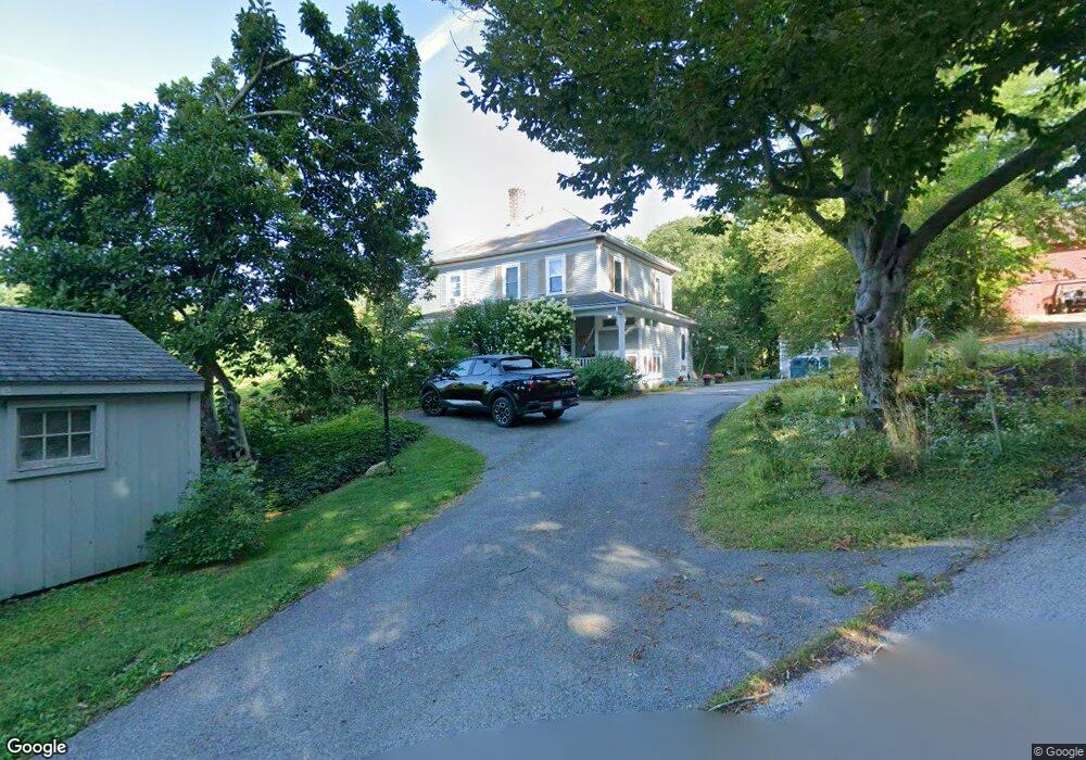
110 Ballou Ln Williamstown, MA 01267
Estimated Value: $372,000 - $545,000
5
Beds
2
Baths
1,760
Sq Ft
$283/Sq Ft
Est. Value
About This Home
This home is located at 110 Ballou Ln, Williamstown, MA 01267 and is currently estimated at $497,633, approximately $282 per square foot. 110 Ballou Ln is a home located in Berkshire County with nearby schools including Williamstown Elementary School, Lanesborough Elementary School, and Mt. Greylock Regional High School.
Ownership History
Date
Name
Owned For
Owner Type
Purchase Details
Closed on
Dec 10, 1993
Sold by
Murray Marshall B and Gray-Murray Jo Ann B
Bought by
Payne Stephen and Stein-Payne Carol
Current Estimated Value
Home Financials for this Owner
Home Financials are based on the most recent Mortgage that was taken out on this home.
Original Mortgage
$159,907
Interest Rate
6.78%
Mortgage Type
Purchase Money Mortgage
Create a Home Valuation Report for This Property
The Home Valuation Report is an in-depth analysis detailing your home's value as well as a comparison with similar homes in the area
Home Values in the Area
Average Home Value in this Area
Purchase History
| Date | Buyer | Sale Price | Title Company |
|---|---|---|---|
| Payne Stephen | $159,000 | -- |
Source: Public Records
Mortgage History
| Date | Status | Borrower | Loan Amount |
|---|---|---|---|
| Open | Payne Stephen | $227,000 | |
| Closed | Payne Stephen | $159,907 | |
| Previous Owner | Payne Stephen | $12,500 |
Source: Public Records
Tax History Compared to Growth
Tax History
| Year | Tax Paid | Tax Assessment Tax Assessment Total Assessment is a certain percentage of the fair market value that is determined by local assessors to be the total taxable value of land and additions on the property. | Land | Improvement |
|---|---|---|---|---|
| 2025 | $6,751 | $489,200 | $125,800 | $363,400 |
| 2024 | $6,749 | $445,500 | $118,800 | $326,700 |
| 2023 | $6,531 | $403,900 | $107,600 | $296,300 |
| 2022 | $6,039 | $356,900 | $104,100 | $252,800 |
| 2021 | $5,752 | $332,500 | $104,100 | $228,400 |
| 2020 | $6,454 | $366,700 | $104,300 | $262,400 |
| 2019 | $7,092 | $392,900 | $185,800 | $207,100 |
| 2018 | $7,049 | $392,900 | $185,800 | $207,100 |
| 2017 | $6,695 | $392,900 | $185,800 | $207,100 |
| 2016 | $6,204 | $392,900 | $185,800 | $207,100 |
| 2015 | $5,843 | $374,300 | $167,200 | $207,100 |
| 2014 | $5,548 | $363,100 | $159,000 | $204,100 |
Source: Public Records
Map
Nearby Homes
- 136 Sand Springs Rd
- 363 Henderson Rd
- 127 Lindley Terrace
- 910 N Hoosac Rd
- 480 North St
- 1030 Simonds Rd
- 1025 Simonds Rd
- 672 N Hoosac Rd Unit 676
- 0 Northwest Hill
- 111 Park St
- 111 North St
- 108 Berkshire Dr
- 14 Orchard Ln
- 15 Orchard Ln
- 12 River Run
- 160 Water St Unit 209
- 160 Water St Unit 309
- 160 Water St Unit 1RR_U1
- 160 Water St Unit 23
- 160 Water St Unit 103
- 112 Ballou Ln
- 106 Ballou Ln
- 115 Ballou Ln
- 96 Ballou Ln
- 86 Ballou Ln
- 83 Ballou Ln
- 113 Ballou Ln
- 242 White Oaks Rd
- 228 White Oaks Rd
- 248 White Oaks Rd
- 67 Ballou Ln
- 70 Ballou Ln
- 54 Ballou Ln
- 315 White Oaks Rd
- 291 White Oaks Rd
- 237 White Oaks Rd
- 42 Ballou Ln
- 223 White Oak Rd
- 223 White Oaks Rd
- 213 White Oaks Rd