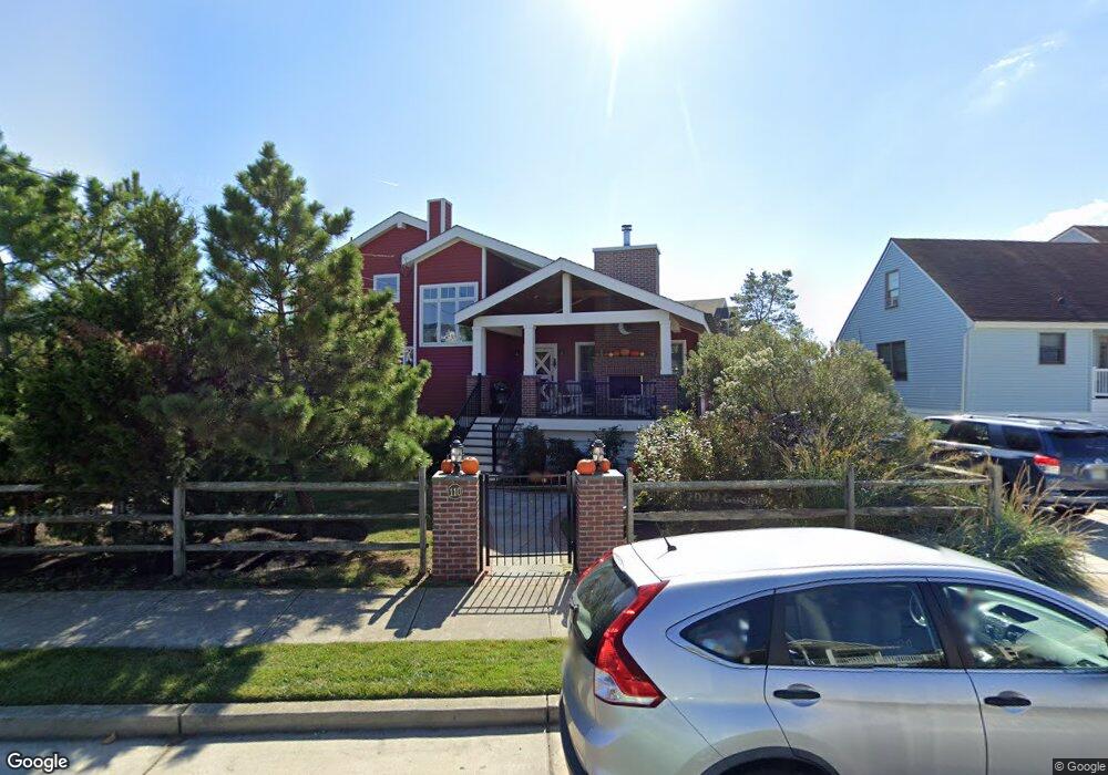
110 Bartram Ln Ocean City, NJ 08226
Estimated Value: $989,602 - $1,640,000
--
Bed
--
Bath
2,550
Sq Ft
$529/Sq Ft
Est. Value
About This Home
This home is located at 110 Bartram Ln, Ocean City, NJ 08226 and is currently estimated at $1,349,901, approximately $529 per square foot. 110 Bartram Ln is a home located in Cape May County with nearby schools including Ocean City Primary School, Ocean City Intermediate School, and Ocean City High School.
Ownership History
Date
Name
Owned For
Owner Type
Purchase Details
Closed on
Dec 13, 2011
Sold by
Ault James Peter and Ault Bonnie Lynn
Bought by
Ault James Peter and Ault Bonnie L
Current Estimated Value
Home Financials for this Owner
Home Financials are based on the most recent Mortgage that was taken out on this home.
Original Mortgage
$367,000
Outstanding Balance
$37,809
Interest Rate
3.23%
Mortgage Type
New Conventional
Estimated Equity
$1,312,092
Purchase Details
Closed on
Nov 29, 1995
Sold by
Fulton William
Bought by
Ault Peter
Home Financials for this Owner
Home Financials are based on the most recent Mortgage that was taken out on this home.
Original Mortgage
$142,000
Interest Rate
7.37%
Purchase Details
Closed on
Dec 11, 1989
Sold by
State Of Njdep
Bought by
Fulton William and Fulton Pamela
Create a Home Valuation Report for This Property
The Home Valuation Report is an in-depth analysis detailing your home's value as well as a comparison with similar homes in the area
Home Values in the Area
Average Home Value in this Area
Purchase History
| Date | Buyer | Sale Price | Title Company |
|---|---|---|---|
| Ault James Peter | -- | First American Title Ins Co | |
| Ault Peter | $158,000 | -- | |
| Fulton William | $6,800 | -- |
Source: Public Records
Mortgage History
| Date | Status | Borrower | Loan Amount |
|---|---|---|---|
| Open | Ault James Peter | $367,000 | |
| Closed | Ault Peter | $142,000 |
Source: Public Records
Tax History Compared to Growth
Tax History
| Year | Tax Paid | Tax Assessment Tax Assessment Total Assessment is a certain percentage of the fair market value that is determined by local assessors to be the total taxable value of land and additions on the property. | Land | Improvement |
|---|---|---|---|---|
| 2025 | $5,744 | $511,900 | $246,200 | $265,700 |
| 2024 | $5,744 | $511,900 | $246,200 | $265,700 |
| 2023 | $5,482 | $511,900 | $246,200 | $265,700 |
| 2022 | $5,267 | $511,900 | $246,200 | $265,700 |
| 2021 | $3,819 | $511,900 | $246,200 | $265,700 |
| 2020 | $4,628 | $473,200 | $246,200 | $227,000 |
| 2019 | $4,576 | $473,200 | $246,200 | $227,000 |
| 2018 | $4,533 | $473,200 | $246,200 | $227,000 |
| 2017 | $4,462 | $473,200 | $246,200 | $227,000 |
| 2016 | $4,292 | $473,200 | $246,200 | $227,000 |
| 2015 | $4,235 | $473,200 | $246,200 | $227,000 |
| 2014 | $4,174 | $473,200 | $246,200 | $227,000 |
Source: Public Records
Map
Nearby Homes
- 3604 Oxford Ln
- 3700 Oxford Ln
- 3708 Westminster Ln
- 103 Somerset Ln
- 17 36th St Unit 111
- 3551 Bay Ave Unit 34
- 215 Limpet Dr Unit 215
- 3716 18 West Ave
- 3432 Haven Ave Unit I
- 3649 West Ave Unit 1
- 507 Conch Dr
- 515 Conch Dr Unit 515 Conch
- 3313 Bay Ave
- 3809 W #1 Ave Unit 1
- 3815 West Ave Unit 2nd floor
- 3813-15 West
- 3332 Simpson Ave
- 3809 West Ave Unit 1
- 3813 West Ave Unit 1st floor
- 3311 Simpson Ave Unit 2
- 3602 Pembroke Ln
- 112 Bartram Ln
- 3604 Pembroke Ln
- 114 Bartram Ln
- 119 Bartram Ln
- 108 Bartram Ln
- 121 Bartram Ln
- 3606 Pembroke Ln
- 117 Bartram Ln
- 116 Bartram Ln
- 123 Bartram Ln
- 3603 Pembroke Ln
- 115 Bartram Ln
- 125 Bartram Ln
- 3608 Pembroke Ln
- 3605 Pembroke Ln
- 113 Bartram Ln
- 106 Bartram Ln
- 127 Bartram Ln
- 3703 Westminster Ln