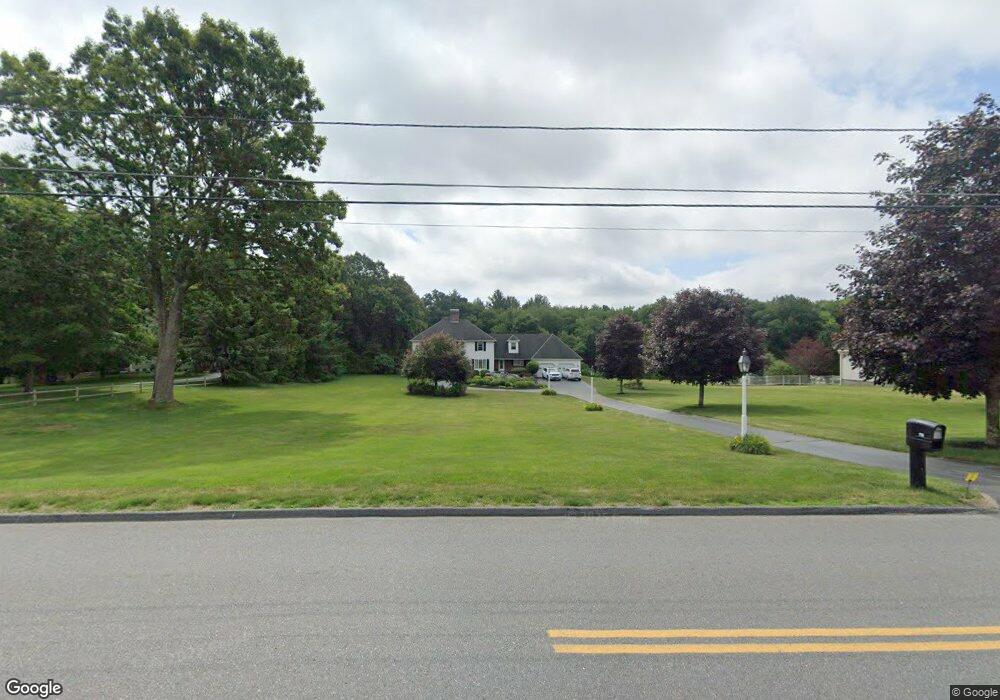
110 Fitzpatrick Rd Grafton, MA 01519
Estimated Value: $846,506 - $889,000
4
Beds
3
Baths
3,003
Sq Ft
$292/Sq Ft
Est. Value
About This Home
This home is located at 110 Fitzpatrick Rd, Grafton, MA 01519 and is currently estimated at $877,377, approximately $292 per square foot. 110 Fitzpatrick Rd is a home located in Worcester County with nearby schools including Grafton High School, Silver Spruce Montessori School, and Assumption School.
Ownership History
Date
Name
Owned For
Owner Type
Purchase Details
Closed on
Sep 26, 2022
Sold by
Turano Annemarie
Bought by
A Marie Turano Ret 2022
Current Estimated Value
Purchase Details
Closed on
Jan 24, 2005
Sold by
Turano Annemarie and Turano Anthony
Bought by
Turano Annemarie and Turano Anthony
Home Financials for this Owner
Home Financials are based on the most recent Mortgage that was taken out on this home.
Original Mortgage
$446,000
Interest Rate
5.71%
Mortgage Type
Purchase Money Mortgage
Create a Home Valuation Report for This Property
The Home Valuation Report is an in-depth analysis detailing your home's value as well as a comparison with similar homes in the area
Home Values in the Area
Average Home Value in this Area
Purchase History
| Date | Buyer | Sale Price | Title Company |
|---|---|---|---|
| A Marie Turano Ret 2022 | -- | None Available | |
| Turano Annemarie | -- | -- |
Source: Public Records
Mortgage History
| Date | Status | Borrower | Loan Amount |
|---|---|---|---|
| Previous Owner | Turano Annemarie | $446,000 |
Source: Public Records
Tax History
| Year | Tax Paid | Tax Assessment Tax Assessment Total Assessment is a certain percentage of the fair market value that is determined by local assessors to be the total taxable value of land and additions on the property. | Land | Improvement |
|---|---|---|---|---|
| 2025 | $10,781 | $773,400 | $223,300 | $550,100 |
| 2024 | $10,568 | $738,500 | $212,600 | $525,900 |
| 2023 | $10,010 | $637,200 | $212,600 | $424,600 |
| 2022 | $9,289 | $550,300 | $182,300 | $368,000 |
| 2021 | $9,004 | $524,100 | $165,600 | $358,500 |
| 2020 | $8,600 | $521,200 | $165,600 | $355,600 |
| 2019 | $7,915 | $475,100 | $145,700 | $329,400 |
| 2018 | $7,696 | $463,900 | $145,300 | $318,600 |
| 2017 | $7,503 | $457,500 | $138,900 | $318,600 |
| 2016 | $7,244 | $432,500 | $128,300 | $304,200 |
| 2015 | $7,074 | $428,700 | $121,500 | $307,200 |
| 2014 | $6,708 | $439,600 | $147,100 | $292,500 |
Source: Public Records
Map
Nearby Homes
- 28 Cortland Way
- 14 Cortland Way
- 9 Danielle Dr
- 46 Lexington Rd
- 8 Autumn Gate Cir
- Lot 1 Cooper Rd
- 19 Fitzpatrick Rd
- 75 Potter Hill Rd
- 13 Pullard Rd Unit 31
- 48 Londonderry Rd
- 51 Londonderry Rd Unit 51
- 67 Providence Rd Unit 1
- 22 Elmwood St
- 268 Magill Dr Unit 268
- 63 Providence Rd Unit 2
- 252 Magill Dr Unit 252
- 109 Main St
- 53 Nottingham Rd
- 66 Buttonwood Ave
- 64 Fisherville Terrace
- 114 Fitzpatrick Rd
- 108 Fitzpatrick Rd
- 116 Fitzpatrick Rd
- 106 Fitzpatrick Rd
- 0 Cronin Brook Unit 30166349
- 0 Cronin Brook Unit 30166342
- 0 Cronin Brook Unit 30166337
- 0 Cronin Brook Unit 30166284
- 0 Cronin Brook Unit 30166282
- 0 Cronin Brook Unit 30153727
- 0 Cronin Brook Unit 30153746
- 0 Cronin Brook Unit 30153732
- 0 Cronin Brook Unit 30153741
- 0 Cronin Brook Unit 30153723
- 2 Lottie Dr
- 1 Lottie Dr
- 109 Fitzpatrick Rd
- 4 Lottie Dr
- 102 Fitzpatrick Rd
- 100 Fitzpatrick Rd
Your Personal Tour Guide
Ask me questions while you tour the home.