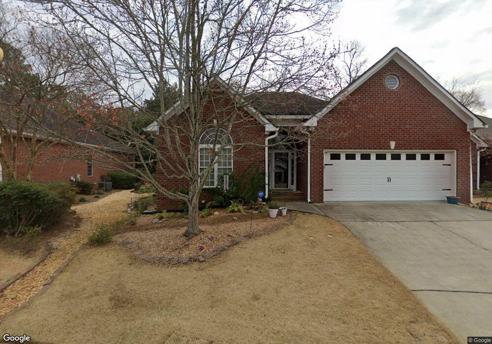
110 Flatrock Ct Athens, GA 30605
Estimated Value: $374,000 - $441,000
3
Beds
2
Baths
1,831
Sq Ft
$215/Sq Ft
Est. Value
About This Home
This home is located at 110 Flatrock Ct, Athens, GA 30605 and is currently estimated at $394,293, approximately $215 per square foot. 110 Flatrock Ct is a home located in Clarke County with nearby schools including Barnett Shoals Elementary School, Hilsman Middle School, and Cedar Shoals High School.
Ownership History
Date
Name
Owned For
Owner Type
Purchase Details
Closed on
Aug 11, 2022
Sold by
Davis Mary Sanford
Bought by
Brown Luann
Current Estimated Value
Purchase Details
Closed on
Jul 29, 2004
Sold by
Chester Bernice A and Shane Bo M
Bought by
Davis James Elmo and Mary Sanford Dav
Purchase Details
Closed on
Jun 20, 2003
Sold by
Chester Bernice A
Bought by
Chester Bernice A and Shane Bowers M
Purchase Details
Closed on
May 9, 2003
Sold by
Marbut James D
Bought by
Chester Bernice A
Purchase Details
Closed on
Mar 27, 2002
Sold by
Marbut Richard H
Bought by
Marbut James D
Create a Home Valuation Report for This Property
The Home Valuation Report is an in-depth analysis detailing your home's value as well as a comparison with similar homes in the area
Home Values in the Area
Average Home Value in this Area
Purchase History
| Date | Buyer | Sale Price | Title Company |
|---|---|---|---|
| Brown Luann | $400,000 | -- | |
| Davis James Elmo | $199,600 | -- | |
| Chester Bernice A | -- | -- | |
| Chester Bernice A | $172,900 | -- | |
| Marbut James D | -- | -- |
Source: Public Records
Tax History Compared to Growth
Tax History
| Year | Tax Paid | Tax Assessment Tax Assessment Total Assessment is a certain percentage of the fair market value that is determined by local assessors to be the total taxable value of land and additions on the property. | Land | Improvement |
|---|---|---|---|---|
| 2025 | $4,627 | $149,021 | $12,000 | $137,021 |
| 2024 | $4,627 | $141,296 | $12,000 | $129,296 |
| 2023 | $4,416 | $138,756 | $12,000 | $126,756 |
| 2022 | $2,467 | $112,398 | $12,000 | $100,398 |
| 2021 | $2,488 | $104,175 | $12,000 | $92,175 |
| 2020 | $2,446 | $101,148 | $12,000 | $89,148 |
| 2019 | $2,383 | $94,977 | $12,000 | $82,977 |
| 2018 | $2,323 | $90,696 | $12,000 | $78,696 |
| 2017 | $2,127 | $76,626 | $12,000 | $64,626 |
| 2016 | $2,143 | $77,759 | $12,000 | $65,759 |
| 2015 | $2,097 | $74,468 | $12,000 | $62,468 |
| 2014 | $2,078 | $73,125 | $12,000 | $61,125 |
Source: Public Records
Map
Nearby Homes
- 0 Barnett Shoals Rd Unit Lot 2
- 0 Barnett Shoals Rd Unit Lot 1
- 211 Stonecrest Ct
- 150 Greenwood Ln
- 157 Wakefield Trace
- 148 Warren Way
- 135 Wakefield Dr
- 430 Forest Rd
- 200 Wiltshire Dr
- 153 Stonybrook Ct
- 123 Stonybrook Ct
- 140 Whitehall Rd
- 400 Ansley Dr
- 171 Birch Valley Dr
- 170 Brookwood Dr
- 352 Greencrest Dr
- 108 Flatrock Ct
- 112 Flatrock Ct
- 114 Flatrock Ct
- 106 Rockford Dr
- 113 Flatrock Ct
- 104 Rockford Dr
- 116 Flatrock Ct
- 131 Flatrock Ct
- 109 Rockford Dr
- 118 Flatrock Ct
- 102 Rockford Dr
- 129 Flatrock Ct
- 204 Stonecrest Ct
- 100 Rockford Dr
- 120 Flatrock Ct
- 205 Stonecrest Ct
- 127 Flatrock Ct
- 201 Rockford Dr
- 125 Flatrock Ct
- 123 Flatrock Ct