Estimated Value: $494,845 - $609,000
4
Beds
1
Bath
922
Sq Ft
$607/Sq Ft
Est. Value
About This Home
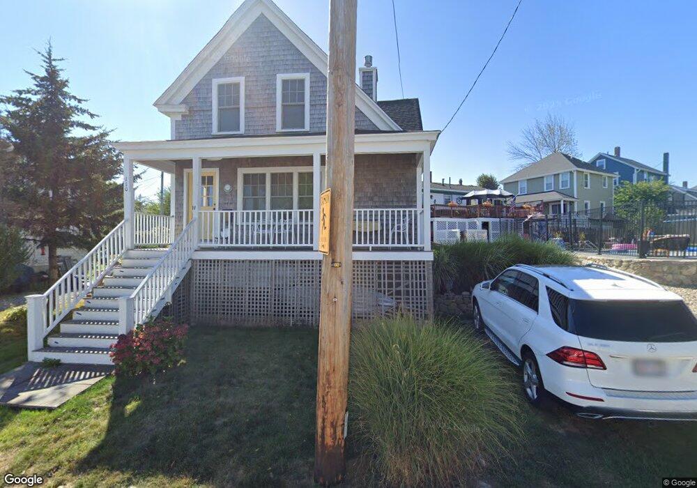
This home is located at 110 Hampton Cir, Hull, MA 02045 and is currently estimated at $559,961, approximately $607 per square foot. 110 Hampton Cir is a home located in Plymouth County with nearby schools including Lillian M. Jacobs Elementary School, Memorial Middle School, and Hull High School.
Ownership History
Date
Name
Owned For
Owner Type
Purchase Details
Closed on
Mar 9, 2025
Sold by
Doiron Hampton Circle T and Doiron
Bought by
Doiron Michael J and Doiron Ayanna P
Current Estimated Value
Purchase Details
Closed on
Nov 5, 2009
Sold by
Doiron Michael
Bought by
Doiron Hampton Circle and Doiron
Purchase Details
Closed on
Apr 30, 1998
Sold by
Damato Karen A and Cardalino Lois
Bought by
Doiron Michael J
Create a Home Valuation Report for This Property
The Home Valuation Report is an in-depth analysis detailing your home's value as well as a comparison with similar homes in the area
Purchase History
| Date | Buyer | Sale Price | Title Company |
|---|---|---|---|
| Doiron Michael J | -- | None Available | |
| Doiron Michael J | -- | None Available | |
| Doiron Hampton Circle | -- | -- | |
| Doiron Hampton Circle | -- | -- | |
| Doiron Michael J | $69,000 | -- | |
| Doiron Michael J | $69,000 | -- |
Source: Public Records
Mortgage History
| Date | Status | Borrower | Loan Amount |
|---|---|---|---|
| Previous Owner | Doiron Michael J | $186,000 | |
| Previous Owner | Doiron Michael J | $128,100 | |
| Previous Owner | Doiron Michael J | $74,000 |
Source: Public Records
Tax History
| Year | Tax Paid | Tax Assessment Tax Assessment Total Assessment is a certain percentage of the fair market value that is determined by local assessors to be the total taxable value of land and additions on the property. | Land | Improvement |
|---|---|---|---|---|
| 2025 | $4,602 | $410,900 | $176,900 | $234,000 |
| 2024 | $4,637 | $398,000 | $171,200 | $226,800 |
| 2023 | $4,544 | $373,400 | $159,800 | $213,600 |
| 2022 | $4,414 | $352,000 | $148,400 | $203,600 |
| 2021 | $5,440 | $327,300 | $131,300 | $196,000 |
| 2020 | $5,247 | $304,500 | $131,300 | $173,200 |
| 2019 | $5,122 | $288,600 | $125,500 | $163,100 |
| 2018 | $4,847 | $273,300 | $125,500 | $147,800 |
| 2017 | $4,565 | $263,200 | $125,500 | $137,700 |
| 2016 | $3,548 | $263,200 | $125,500 | $137,700 |
| 2015 | $3,392 | $243,300 | $105,600 | $137,700 |
| 2014 | $3,375 | $243,300 | $105,600 | $137,700 |
Source: Public Records
Map
Nearby Homes
- 127 Hampton Cir
- 18 Standish Rd
- 137 Hampton Cir
- 3 3rd St
- 7 Bay St Unit 10
- 53 Mountford Rd
- 2 6th St
- 00 George Washington Blvd
- 155 George Washington Blvd Unit 210
- 141 Edgewater Rd
- 10 Berkley Rd Unit A
- 22 Berkley Rd Unit B
- 23 Wyola Rd
- 121 Nantasket Ave Unit 503
- 48 Bates St
- 120 Nantasket Ave Unit 207
- 120 Nantasket Ave Unit 204
- 120 Nantasket Ave Unit 304
- 120 Nantasket Ave Unit PH5
- 120 Nantasket Ave Unit 201
- 112 Hampton Cir
- 9 Old Colony Rd
- 106 Hampton Cir
- 109 Hampton Cir
- 120 Hampton Cir
- 10 Old Colony Rd
- 10 Old Colony Rd
- 12 Old Colony Rd
- 107 Hampton Cir
- 18 Marginal Rd
- 17 Marginal Rd
- 105 Hampton Cir
- 104 Hampton Cir
- 8 Old Colony Rd
- 5 Old Colony Rd
- 16 Marginal Rd
- 122 Hampton Cir
- 15 Marginal Rd
- 103 Hampton Cir
- 3 Old Colony Rd
Your Personal Tour Guide
Ask me questions while you tour the home.