R
Seller's Agent in 2025
Rebecca Quirk
Berkshire Hathaway HomeServices Commonwealth Real Estate
(617) 957-5164
30 Total Sales


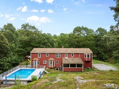


Expansive and versitile four bedroom + bonus room cape style home with unique floor plan including a private in-law suite just ready for your own personal touches! Set on over one acre of private land and offering a large mudroom, 2 car attached garage and inviting above ground pool ready to be enjoyed by new owners! Whether you're looking to customize your dream home or make strategic updates, this property is ready for your own personal style.
Last Agent to Sell the Property
Berkshire Hathaway HomeServices Commonwealth Real Estate Listed on: 07/15/2025

| Date | Type | Sale Price | Title Company |
|---|---|---|---|
| Deed | $645,000 | -- | |
| Land Court Massachusetts | $345,000 | -- | |
| Land Court Massachusetts | $345,000 | -- | |
| Land Court Massachusetts | $144,885 | -- | |
| Land Court Massachusetts | $144,885 | -- |
| Date | Status | Loan Amount | Loan Type |
|---|---|---|---|
| Open | $387,000 | Purchase Money Mortgage | |
| Previous Owner | $338,751 | Purchase Money Mortgage | |
| Previous Owner | $280,000 | Purchase Money Mortgage |
| Date | Event | Price | List to Sale | Price per Sq Ft |
|---|---|---|---|---|
| 10/10/2025 10/10/25 | Sold | $645,000 | -0.8% | $271 / Sq Ft |
| 08/09/2025 08/09/25 | Pending | -- | -- | -- |
| 08/07/2025 08/07/25 | Price Changed | $650,000 | -7.1% | $273 / Sq Ft |
| 07/15/2025 07/15/25 | For Sale | $700,000 | -- | $294 / Sq Ft |
| Year | Tax Paid | Tax Assessment Tax Assessment Total Assessment is a certain percentage of the fair market value that is determined by local assessors to be the total taxable value of land and additions on the property. | Land | Improvement |
|---|---|---|---|---|
| 2025 | $6,938 | $598,600 | $263,600 | $335,000 |
| 2024 | $6,719 | $559,900 | $263,600 | $296,300 |
| 2023 | $6,591 | $522,300 | $239,600 | $282,700 |
| 2022 | $6,510 | $476,200 | $233,000 | $243,200 |
| 2021 | $6,326 | $449,600 | $217,800 | $231,800 |
| 2020 | $6,167 | $432,800 | $166,400 | $266,400 |
| 2019 | $5,929 | $419,900 | $166,400 | $253,500 |
| 2018 | $5,611 | $394,000 | $166,600 | $227,400 |
| 2017 | $5,274 | $370,100 | $163,400 | $206,700 |
| 2016 | $5,159 | $361,300 | $158,600 | $202,700 |
| 2015 | $4,957 | $330,900 | $152,500 | $178,400 |
| 2014 | $4,913 | $320,900 | $146,700 | $174,200 |
R
Seller's Agent in 2025
Rebecca Quirk
Berkshire Hathaway HomeServices Commonwealth Real Estate
(617) 957-5164
30 Total Sales
J
Buyer's Agent in 2025
Jackie Washington
Compass
8 Total Sales
Source: MLS Property Information Network (MLS PIN)
MLS Number: 73404411
APN: WREN-000007O-000001-000009
Disclaimer: Certain information contained herein is derived from information provided by parties other than Homes.com. All information provided is deemed reliable, but is not guaranteed to be accurate and should be independently verified.
![]() The property listing data and information, or the Images, set forth herein were provided to MLS Property Information Network, Inc. from third party sources, including sellers, lessors and public records, and were compiled by MLS Property Information Network, Inc. The property listing data and information, and the Images, are for the personal, non-commercial use of consumers having a good faith interest in purchasing or leasing listed properties of the type displayed to them and may not be used for any purpose other than to identify prospective properties which such consumers may have a good faith interest in purchasing or leasing. MLS Property Information Network, Inc. and its subscribers disclaim any and all representations and warranties as to the accuracy of the property listing data and information, or as to the accuracy of any of the Images, set forth herein.
The property listing data and information, or the Images, set forth herein were provided to MLS Property Information Network, Inc. from third party sources, including sellers, lessors and public records, and were compiled by MLS Property Information Network, Inc. The property listing data and information, and the Images, are for the personal, non-commercial use of consumers having a good faith interest in purchasing or leasing listed properties of the type displayed to them and may not be used for any purpose other than to identify prospective properties which such consumers may have a good faith interest in purchasing or leasing. MLS Property Information Network, Inc. and its subscribers disclaim any and all representations and warranties as to the accuracy of the property listing data and information, or as to the accuracy of any of the Images, set forth herein.