C
Seller's Agent in 2025
Carolyn Sheldrick
William Raveis Real Estate & Home Services
(508) 280-9278
26 in this area
26 Total Sales

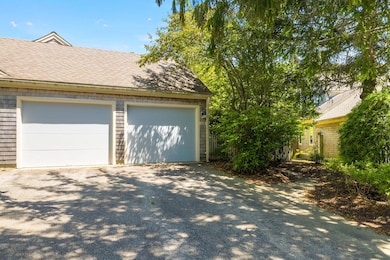
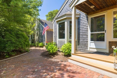

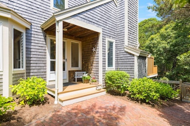

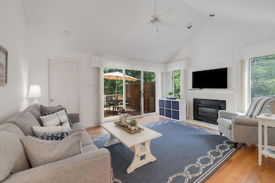
Welcome to 110 Kate's Path - Popular D model townhome with a lovely courtyard in Kings Way, Cape Cod's premier condo community. The first floor offers spacious breakfast room/kitchen area with stainless steel appliances, new microwave and dishwasher, dining, living room with gas fireplace, cathedral ceilings and sliders to the deck, primary suite has cathedral ceilings, walk-in closet and private bath ensuring effortless one-floor living. On the second floor there is a second bedroom, full bath and loft - ideal for a home office or den. The finished walkout lower level expands your living options with a large family room, den, full bath and plenty of storage adding 1,165 SF of finished space - perfect for guests or entertaining. Gleaming hardwood floors on the 1st floor and lower level. Come and enjoy the Kings Way lifestyle with many amenities including a golf course, restaurant, 2 pools, tennis and pickle ball courts, meeting house, social center/post office and year-round social activities. Don't miss your opportunity to enjoy carefree Cape Cod living in one of Yarmouth Port's most desirable communities. Schedule your visit to 110 Kate's Path today!
Last Agent to Sell the Property
William Raveis Real Estate & Home Services License #72822 Listed on: 06/18/2025

| Date | Type | Sale Price | Title Company |
|---|---|---|---|
| Deed | $685,500 | -- | |
| Deed | $270,000 | -- | |
| Deed | $270,000 | -- | |
| Land Court Massachusetts | -- | -- |
| Date | Status | Loan Amount | Loan Type |
|---|---|---|---|
| Previous Owner | $1,329,122 | No Value Available |
| Date | Event | Price | List to Sale | Price per Sq Ft |
|---|---|---|---|---|
| 09/24/2025 09/24/25 | Sold | $685,500 | -1.9% | $247 / Sq Ft |
| 08/12/2025 08/12/25 | Pending | -- | -- | -- |
| 07/09/2025 07/09/25 | Price Changed | $699,000 | -2.8% | $252 / Sq Ft |
| 06/18/2025 06/18/25 | For Sale | $719,000 | -- | $259 / Sq Ft |
| Year | Tax Paid | Tax Assessment Tax Assessment Total Assessment is a certain percentage of the fair market value that is determined by local assessors to be the total taxable value of land and additions on the property. | Land | Improvement |
|---|---|---|---|---|
| 2025 | $4,026 | $568,700 | $0 | $568,700 |
| 2024 | $3,743 | $507,200 | $0 | $507,200 |
| 2023 | $3,647 | $449,700 | $0 | $449,700 |
| 2022 | $4,164 | $453,600 | $0 | $453,600 |
| 2021 | $4,052 | $423,900 | $0 | $423,900 |
| 2020 | $4,091 | $409,100 | $0 | $409,100 |
| 2019 | $3,838 | $380,000 | $0 | $380,000 |
| 2018 | $3,611 | $350,900 | $0 | $350,900 |
| 2017 | $3,371 | $336,400 | $0 | $336,400 |
| 2016 | $3,212 | $321,800 | $0 | $321,800 |
| 2015 | $3,314 | $330,100 | $0 | $330,100 |
C
Seller's Agent in 2025
Carolyn Sheldrick
William Raveis Real Estate & Home Services
(508) 280-9278
26 in this area
26 Total Sales
Buyer's Agent in 2025
Susan Peterson
Today Real Estate
(774) 722-0498
1 in this area
41 Total Sales
Source: Cape Cod & Islands Association of REALTORS®
MLS Number: 22502993
APN: YARM-000142-000001-000110-C000000
Disclaimer: Certain information contained herein is derived from information provided by parties other than Homes.com. All information provided is deemed reliable, but is not guaranteed to be accurate and should be independently verified.
![]() All data relating to real estate for sale on this page comes from the Broker Reciprocity (BR) of the Cape Cod & Islands Multiple Listing Service, Inc. Detailed information about real estate listings held by brokerage firms other than CC&I Assoc. of REALTORS®, Inc. includes the name of the listing company. Neither the listing company nor CC&I Assoc. of REALTORS®, Inc. shall be responsible for any typographical errors, misinformation, misprints and shall be held totally harmless. The Broker providing this data believes it to be correct, but advises interested parties to confirm any item before relying on it in a purchase decision. All properties are subject to prior sale, changes, or withdrawal. Copyright 2025 © Cape Cod & Islands Multiple Listing Service, Inc. All rights reserved.
All data relating to real estate for sale on this page comes from the Broker Reciprocity (BR) of the Cape Cod & Islands Multiple Listing Service, Inc. Detailed information about real estate listings held by brokerage firms other than CC&I Assoc. of REALTORS®, Inc. includes the name of the listing company. Neither the listing company nor CC&I Assoc. of REALTORS®, Inc. shall be responsible for any typographical errors, misinformation, misprints and shall be held totally harmless. The Broker providing this data believes it to be correct, but advises interested parties to confirm any item before relying on it in a purchase decision. All properties are subject to prior sale, changes, or withdrawal. Copyright 2025 © Cape Cod & Islands Multiple Listing Service, Inc. All rights reserved.