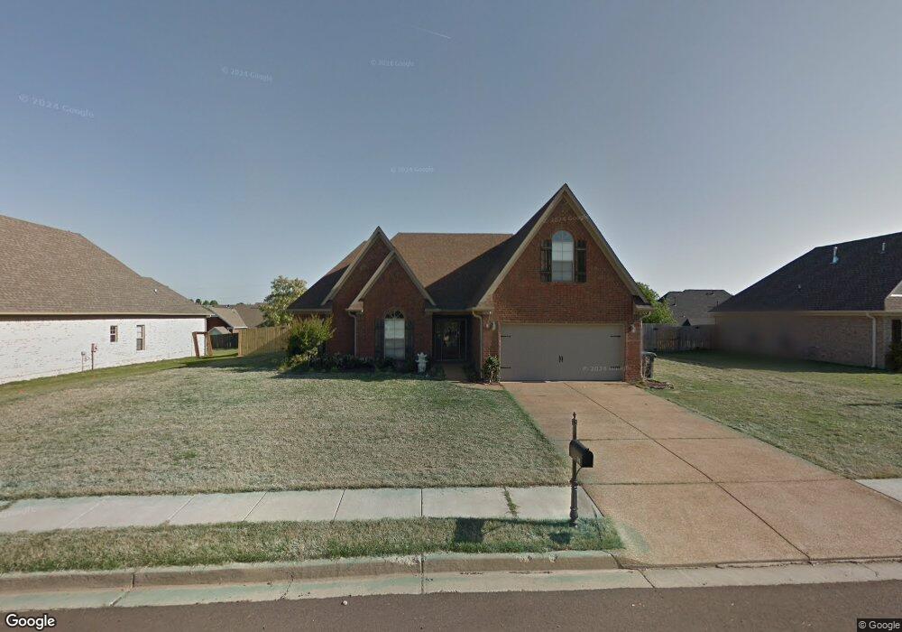
110 Lake Front Dr N Hernando, MS 38632
Estimated Value: $288,000 - $319,000
3
Beds
2
Baths
1,834
Sq Ft
$163/Sq Ft
Est. Value
About This Home
This home is located at 110 Lake Front Dr N, Hernando, MS 38632 and is currently estimated at $299,705, approximately $163 per square foot. 110 Lake Front Dr N is a home located in DeSoto County with nearby schools including Oak Grove Central Elementary School, Hernando Elementary School, and Hernando Hills Elementary.
Ownership History
Date
Name
Owned For
Owner Type
Purchase Details
Closed on
May 21, 2018
Sold by
Lafayette Charles T and Lafayette Mindy
Bought by
Jackson Jason B
Current Estimated Value
Home Financials for this Owner
Home Financials are based on the most recent Mortgage that was taken out on this home.
Original Mortgage
$171,000
Outstanding Balance
$146,947
Interest Rate
4.5%
Mortgage Type
New Conventional
Estimated Equity
$152,758
Purchase Details
Closed on
Aug 31, 2010
Sold by
North Ms Home Builders Llc
Bought by
Lafayette Charles T and Mock Elizabeth A
Home Financials for this Owner
Home Financials are based on the most recent Mortgage that was taken out on this home.
Original Mortgage
$152,352
Interest Rate
4.6%
Mortgage Type
FHA
Create a Home Valuation Report for This Property
The Home Valuation Report is an in-depth analysis detailing your home's value as well as a comparison with similar homes in the area
Home Values in the Area
Average Home Value in this Area
Purchase History
| Date | Buyer | Sale Price | Title Company |
|---|---|---|---|
| Jackson Jason B | -- | None Available | |
| Lafayette Charles T | -- | None Available |
Source: Public Records
Mortgage History
| Date | Status | Borrower | Loan Amount |
|---|---|---|---|
| Open | Jackson Jason B | $171,000 | |
| Previous Owner | Lafayette Charles T | $152,352 |
Source: Public Records
Tax History
| Year | Tax Paid | Tax Assessment Tax Assessment Total Assessment is a certain percentage of the fair market value that is determined by local assessors to be the total taxable value of land and additions on the property. | Land | Improvement |
|---|---|---|---|---|
| 2025 | $1,782 | $17,871 | $3,000 | $14,871 |
| 2024 | $1,529 | $13,186 | $3,000 | $10,186 |
| 2023 | $1,529 | $13,186 | $0 | $0 |
| 2022 | $1,529 | $13,186 | $3,000 | $10,186 |
| 2021 | $1,529 | $13,186 | $3,000 | $10,186 |
| 2020 | $1,416 | $12,370 | $0 | $0 |
| 2019 | $1,416 | $12,370 | $3,000 | $9,370 |
| 2017 | $1,489 | $21,966 | $12,483 | $9,483 |
| 2016 | $1,416 | $12,483 | $3,000 | $9,483 |
| 2015 | $1,668 | $21,966 | $12,483 | $9,483 |
| 2014 | $1,376 | $12,483 | $0 | $0 |
| 2013 | $1,377 | $12,483 | $0 | $0 |
Source: Public Records
Map
Nearby Homes
- 1280 S Lake Dr
- 1268 S Lake Dr
- 3 Lake View Dr
- 1 Lake View Dr
- 270 Gaslight Cove
- 1203 Lake View Dr
- 1123 Tara Dr
- 120 N Parkway St
- 509 Howell Way
- 159 Lindsey Dr
- 521 Abey Ln
- 1249 Howell Way
- 911 Clair Cove
- 208 Elkwood Ln
- 1207 Howell Way
- 1679 Sandpiper Cove N
- 1107 Sabrina Dr
- 112 Forked Creek Pkwy
- 124 Pebble Creek Cove E
- 0 S Old Hwy 51 Unit 4105246
- 92 Lake Front Dr N
- 128 Lake Front Dr N
- 115 Cross Creek Dr
- 101 Cross Creek Dr
- 129 Cross Creek Dr
- 89 Cross Creek Dr
- 121 Lake Pointe Dr
- 76 Lake Front Dr N
- 1351 Village Wood Dr
- 55 Cross Creek Dr
- 2904 Cross Over Dr
- 1394 Village Wood Dr
- 107 Lake Pointe Dr
- 159 Cross Creek Dr
- 60 Lake Front Dr N
- 49 Cross Creek Dr
- 1302 Ridge Cove
- 1303 Ridge Cove
- 1385 Village Wood Dr
- 93 Lake Pointe Dr
Your Personal Tour Guide
Ask me questions while you tour the home.