
Seller's Agent in 2025
Paul Colleary
Dream Realty
(617) 388-8351
1 in this area
38 Total Sales
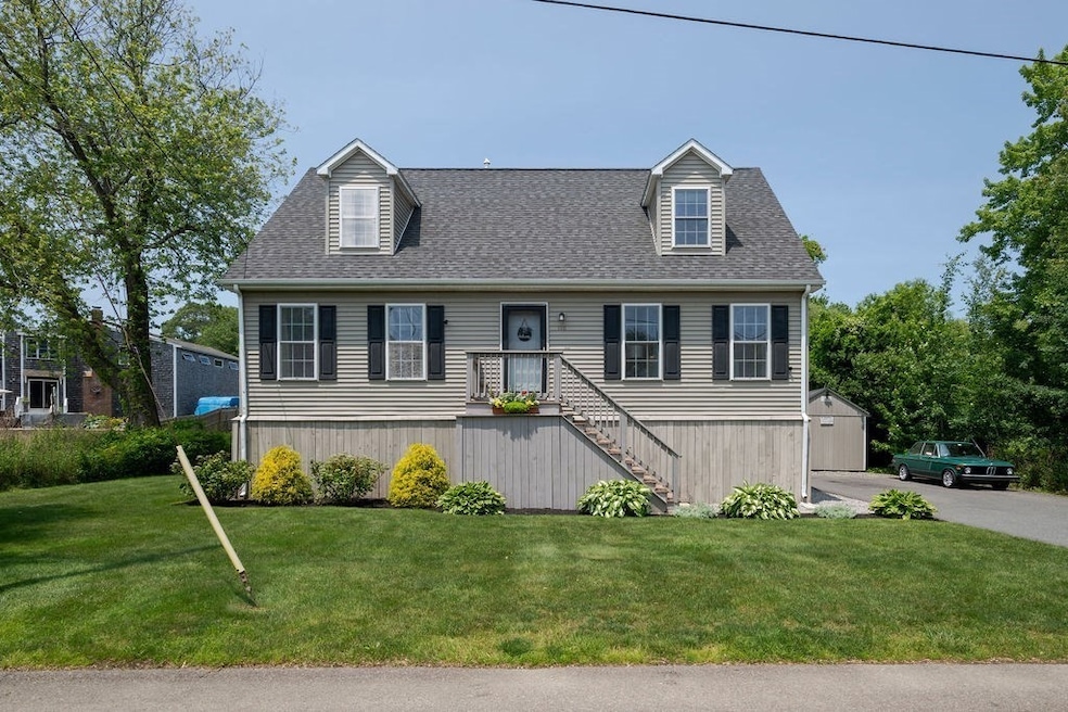
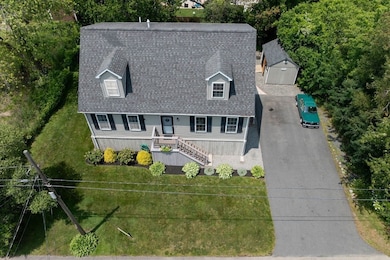
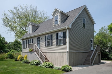
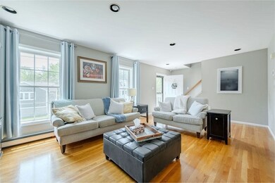

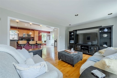
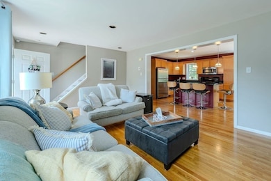
Just two blocks from the water, this 5 bed, 2 full bath cape-style home is what summer dreams are made of! Nestled between Rexhame and Sunrise Beaches this home has everything you need to enjoy all seasons, but even more to make the most of the summers! First floor has open living space, two bedrooms and a full bathroom; second floor includes a large primary bedroom with two closets and en suite bath, and two additional bedrooms. The well-maintained backyard includes a large patio and a shed equipped with electricity that's currently used as an entertaining space. Loads of under-home storage and an outdoor shower make trips to the beach easy, and double-wide driveway allows for plenty of guest parking. This move-in ready home has everything you need to make the most of this summer!
| Date | Type | Sale Price | Title Company |
|---|---|---|---|
| Deed | $870,000 | -- | |
| Leasehold Conv With Agreement Of Sale Fee Purchase Hawaii | $120,000 | -- | |
| Leasehold Conv With Agreement Of Sale Fee Purchase Hawaii | $120,000 | -- | |
| Leasehold Conv With Agreement Of Sale Fee Purchase Hawaii | $120,000 | -- |
| Date | Status | Loan Amount | Loan Type |
|---|---|---|---|
| Open | $650,000 | Purchase Money Mortgage | |
| Previous Owner | $303,000 | No Value Available | |
| Previous Owner | $144,000 | No Value Available | |
| Previous Owner | $25,000 | No Value Available | |
| Previous Owner | $96,000 | Purchase Money Mortgage |
| Date | Event | Price | List to Sale | Price per Sq Ft |
|---|---|---|---|---|
| 08/15/2025 08/15/25 | Sold | $870,000 | -1.1% | $507 / Sq Ft |
| 07/15/2025 07/15/25 | Pending | -- | -- | -- |
| 06/12/2025 06/12/25 | For Sale | $879,900 | -- | $512 / Sq Ft |
| Year | Tax Paid | Tax Assessment Tax Assessment Total Assessment is a certain percentage of the fair market value that is determined by local assessors to be the total taxable value of land and additions on the property. | Land | Improvement |
|---|---|---|---|---|
| 2025 | $5,576 | $563,200 | $319,900 | $243,300 |
| 2024 | $5,424 | $522,000 | $299,900 | $222,100 |
| 2023 | $5,105 | $461,100 | $269,900 | $191,200 |
| 2022 | $5,105 | $394,200 | $229,900 | $164,300 |
| 2021 | $4,820 | $365,400 | $219,900 | $145,500 |
| 2020 | $4,471 | $335,400 | $189,900 | $145,500 |
| 2019 | $4,353 | $325,300 | $189,900 | $135,400 |
| 2018 | $4,252 | $318,000 | $189,900 | $128,100 |
| 2017 | $3,995 | $291,200 | $179,900 | $111,300 |
| 2016 | $3,821 | $275,300 | $169,900 | $105,400 |
| 2015 | $3,659 | $275,300 | $169,900 | $105,400 |
| 2014 | $3,491 | $262,700 | $169,900 | $92,800 |
Seller's Agent in 2025
Paul Colleary
Dream Realty
(617) 388-8351
1 in this area
38 Total Sales
P
Buyer's Agent in 2025
Paul Sadatis
Homie Realty Group
1 in this area
7 Total Sales
Source: MLS Property Information Network (MLS PIN)
MLS Number: 73390460
APN: MARS-000010K-000013-000003
Disclaimer: Certain information contained herein is derived from information provided by parties other than Homes.com. All information provided is deemed reliable, but is not guaranteed to be accurate and should be independently verified.
![]() The property listing data and information, or the Images, set forth herein were provided to MLS Property Information Network, Inc. from third party sources, including sellers, lessors and public records, and were compiled by MLS Property Information Network, Inc. The property listing data and information, and the Images, are for the personal, non-commercial use of consumers having a good faith interest in purchasing or leasing listed properties of the type displayed to them and may not be used for any purpose other than to identify prospective properties which such consumers may have a good faith interest in purchasing or leasing. MLS Property Information Network, Inc. and its subscribers disclaim any and all representations and warranties as to the accuracy of the property listing data and information, or as to the accuracy of any of the Images, set forth herein.
The property listing data and information, or the Images, set forth herein were provided to MLS Property Information Network, Inc. from third party sources, including sellers, lessors and public records, and were compiled by MLS Property Information Network, Inc. The property listing data and information, and the Images, are for the personal, non-commercial use of consumers having a good faith interest in purchasing or leasing listed properties of the type displayed to them and may not be used for any purpose other than to identify prospective properties which such consumers may have a good faith interest in purchasing or leasing. MLS Property Information Network, Inc. and its subscribers disclaim any and all representations and warranties as to the accuracy of the property listing data and information, or as to the accuracy of any of the Images, set forth herein.