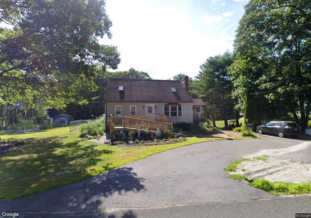
110 Ramshorn Rd Charlton, MA 01507
Estimated Value: $481,926 - $528,000
2
Beds
1
Bath
1,782
Sq Ft
$282/Sq Ft
Est. Value
About This Home
This home is located at 110 Ramshorn Rd, Charlton, MA 01507 and is currently estimated at $502,732, approximately $282 per square foot. 110 Ramshorn Rd is a home located in Worcester County with nearby schools including Shepherd Hill Regional High School.
Ownership History
Date
Name
Owned For
Owner Type
Purchase Details
Closed on
Mar 25, 1998
Sold by
Charette Daniel R and Charette Kathleen M
Bought by
Jacques Robert J and Jacques Sharon L
Current Estimated Value
Purchase Details
Closed on
Jan 22, 1990
Sold by
Dalton Jeffrey
Bought by
Charette Daniel
Create a Home Valuation Report for This Property
The Home Valuation Report is an in-depth analysis detailing your home's value as well as a comparison with similar homes in the area
Home Values in the Area
Average Home Value in this Area
Purchase History
| Date | Buyer | Sale Price | Title Company |
|---|---|---|---|
| Jacques Robert J | $121,000 | -- | |
| Jacques Robert J | $121,000 | -- | |
| Charette Daniel | $129,000 | -- | |
| Charette Daniel | $129,000 | -- |
Source: Public Records
Mortgage History
| Date | Status | Borrower | Loan Amount |
|---|---|---|---|
| Open | Charette Daniel | $141,000 | |
| Closed | Charette Daniel | $5,000 |
Source: Public Records
Tax History Compared to Growth
Tax History
| Year | Tax Paid | Tax Assessment Tax Assessment Total Assessment is a certain percentage of the fair market value that is determined by local assessors to be the total taxable value of land and additions on the property. | Land | Improvement |
|---|---|---|---|---|
| 2025 | $4,190 | $376,500 | $114,600 | $261,900 |
| 2024 | $4,068 | $358,700 | $109,700 | $249,000 |
| 2023 | $3,679 | $302,300 | $88,200 | $214,100 |
| 2022 | $3,438 | $258,700 | $80,200 | $178,500 |
| 2021 | $3,368 | $224,400 | $76,000 | $148,400 |
| 2020 | $3,308 | $221,400 | $73,000 | $148,400 |
| 2019 | $3,270 | $221,400 | $73,000 | $148,400 |
| 2018 | $2,989 | $221,400 | $73,000 | $148,400 |
| 2017 | $2,906 | $206,100 | $67,000 | $139,100 |
| 2016 | $2,840 | $206,100 | $67,000 | $139,100 |
| 2015 | $2,766 | $206,100 | $67,000 | $139,100 |
| 2014 | $2,627 | $207,500 | $69,700 | $137,800 |
Source: Public Records
Map
Nearby Homes
- 65 Haggerty Rd
- 2 Potter Village Rd
- 2 Lelandville Rd
- 3 Lelandville Rd
- 76 Number 6 Schoolhouse Rd
- 58 Colburn Rd
- 0 Partridge Hill Rd
- 16 Sandersdale Rd
- 0 Freeman Rd Unit 73369281
- 60 Saundersdale Rd
- 6 Blackwell Dr
- Lot 1 Mason Road Extension
- Lot 1A Sandersdale Rd
- Lot 3A Sandersdale Rd
- Lot 2A Sandersdale Rd
- 18 Mckinstry Dr
- 337 Mason Road Extension
- 0 Sandersdale Rd
- Lots 1+16 Pierpont Rd
- 0 Blood Rd
- lot 0 Ramshorn Rd
- 108 Ramshorn Rd
- 109 Ramshorn Rd
- 114 Ramshorn Rd
- 118 Ramshorn Rd
- 105 Ramshorn Rd
- 106 Ramshorn Rd
- 119 Ramshorn Rd
- 111 Ramshorn Rd
- 120 Ramshorn Rd
- 121 Ramshorn Rd
- 98 Ramshorn Rd
- 23 Lincoln Point Rd
- 123 Ramshorn Rd
- 97 Ramshorn Rd
- 126 Ramshorn Rd
- 127 Ramshorn Rd
- 25 Lincoln Point Rd
- 25 Lincoln Point Rd
- 93 Ramshorn Rd