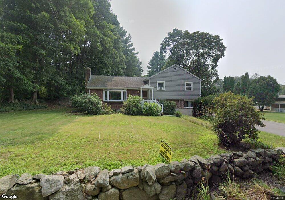
110 Ridge St Millis, MA 02054
Estimated Value: $564,000 - $691,000
3
Beds
3
Baths
1,400
Sq Ft
$447/Sq Ft
Est. Value
About This Home
This home is located at 110 Ridge St, Millis, MA 02054 and is currently estimated at $626,093, approximately $447 per square foot. 110 Ridge St is a home located in Norfolk County with nearby schools including Clyde F Brown, Millis Middle School, and Millis High School.
Ownership History
Date
Name
Owned For
Owner Type
Purchase Details
Closed on
May 29, 1998
Sold by
Lambert Wilfred J
Bought by
Morrissey Richard M and Morrissey Donna
Current Estimated Value
Home Financials for this Owner
Home Financials are based on the most recent Mortgage that was taken out on this home.
Original Mortgage
$165,000
Outstanding Balance
$33,210
Interest Rate
7.12%
Mortgage Type
Purchase Money Mortgage
Estimated Equity
$592,883
Purchase Details
Closed on
Jan 11, 1996
Sold by
Est Levy Lawrence E
Bought by
Lambert Wilfred J
Create a Home Valuation Report for This Property
The Home Valuation Report is an in-depth analysis detailing your home's value as well as a comparison with similar homes in the area
Home Values in the Area
Average Home Value in this Area
Purchase History
| Date | Buyer | Sale Price | Title Company |
|---|---|---|---|
| Morrissey Richard M | $185,500 | -- | |
| Lambert Wilfred J | $127,000 | -- |
Source: Public Records
Mortgage History
| Date | Status | Borrower | Loan Amount |
|---|---|---|---|
| Open | Morrissey Richard M | $165,000 |
Source: Public Records
Tax History Compared to Growth
Tax History
| Year | Tax Paid | Tax Assessment Tax Assessment Total Assessment is a certain percentage of the fair market value that is determined by local assessors to be the total taxable value of land and additions on the property. | Land | Improvement |
|---|---|---|---|---|
| 2025 | $8,111 | $494,600 | $189,300 | $305,300 |
| 2024 | $7,425 | $452,200 | $189,300 | $262,900 |
| 2023 | $7,052 | $403,200 | $164,600 | $238,600 |
| 2022 | $7,584 | $401,700 | $164,600 | $237,100 |
| 2021 | $7,316 | $372,900 | $164,600 | $208,300 |
| 2020 | $7,162 | $355,600 | $153,900 | $201,700 |
| 2019 | $6,272 | $335,400 | $145,100 | $190,300 |
| 2018 | $5,806 | $322,200 | $131,900 | $190,300 |
| 2017 | $6,115 | $332,000 | $139,600 | $192,400 |
| 2016 | $5,790 | $332,000 | $139,600 | $192,400 |
| 2015 | $5,644 | $332,000 | $139,600 | $192,400 |
Source: Public Records
Map
Nearby Homes
- 210 Causeway St
- 22 May Rd
- 27 Pollard Dr
- 2 April Way
- 6 April Way
- 10 April Way
- 324 Union St Unit 6
- 9 Bogastow Cir
- 6 Rivendell Ln
- 1380 Main St
- 84 Middlesex St
- 2 Greenwood Dr
- 50 Walnut St
- 2 Spencer St
- 25 Bayberry Cir Unit 25
- 2 Towne Lyne Rd
- 6 Glen Ellen Blvd Unit 6
- 28 Forest Rd
- 136 Spring St
- 2 Country Village Way Unit 2
- 108 Ridge St
- 116 Ridge St
- 104 Ridge St
- 118 Ridge St
- 449 Union St
- 235 Causeway St
- 98 Ridge St
- 233 Causeway St
- 96 Ridge St
- 445 Union St
- 4 Rolling Meadow Dr
- 2 Rolling Meadow Dr
- 95 Ridge St
- 6 Rolling Meadow Dr
- 232 Causeway St
- 443 Union St
- 94 Ridge St
- 231 Causeway St
- 227 Causeway St Lots 1-4
- Lots 1-4 227 Causeway St