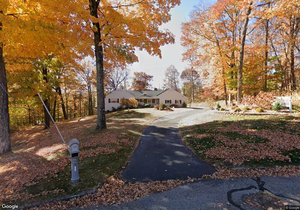
110 Weigands Dr New Britain, CT 06052
Estimated Value: $505,244 - $552,000
3
Beds
4
Baths
3,140
Sq Ft
$168/Sq Ft
Est. Value
About This Home
This home is located at 110 Weigands Dr, New Britain, CT 06052 and is currently estimated at $527,811, approximately $168 per square foot. 110 Weigands Dr is a home located in Hartford County with nearby schools including Lincoln School, Slade Middle School, and Raymond Hill School.
Ownership History
Date
Name
Owned For
Owner Type
Purchase Details
Closed on
Dec 3, 2020
Sold by
Petrisko Paul and Petrisko Joyce L
Bought by
Petrisko Thomas and Perrotta Kimberly
Current Estimated Value
Purchase Details
Closed on
May 29, 1992
Sold by
Schuch William E
Bought by
Petrisko Paul and Petrisko Joyce L
Create a Home Valuation Report for This Property
The Home Valuation Report is an in-depth analysis detailing your home's value as well as a comparison with similar homes in the area
Home Values in the Area
Average Home Value in this Area
Purchase History
| Date | Buyer | Sale Price | Title Company |
|---|---|---|---|
| Petrisko Thomas | -- | None Available | |
| Petrisko Paul | $205,000 | -- |
Source: Public Records
Mortgage History
| Date | Status | Borrower | Loan Amount |
|---|---|---|---|
| Previous Owner | Petrisko Paul | $67,000 | |
| Previous Owner | Petrisko Paul | $50,000 | |
| Previous Owner | Petrisko Paul | $50,000 | |
| Previous Owner | Petrisko Paul | $140,000 |
Source: Public Records
Tax History
| Year | Tax Paid | Tax Assessment Tax Assessment Total Assessment is a certain percentage of the fair market value that is determined by local assessors to be the total taxable value of land and additions on the property. | Land | Improvement |
|---|---|---|---|---|
| 2025 | $12,632 | $322,420 | $105,840 | $216,580 |
| 2024 | $12,765 | $322,420 | $105,840 | $216,580 |
| 2023 | $12,342 | $322,420 | $105,840 | $216,580 |
| 2022 | $10,724 | $216,650 | $48,790 | $167,860 |
| 2021 | $10,724 | $216,650 | $48,790 | $167,860 |
| 2020 | $10,941 | $216,650 | $48,790 | $167,860 |
| 2019 | $10,941 | $216,650 | $48,790 | $167,860 |
| 2018 | $10,941 | $216,650 | $48,790 | $167,860 |
| 2017 | $11,464 | $227,010 | $49,700 | $177,310 |
| 2016 | $11,464 | $227,010 | $49,700 | $177,310 |
| 2015 | $11,123 | $227,010 | $49,700 | $177,310 |
| 2014 | $11,123 | $227,010 | $49,700 | $177,310 |
Source: Public Records
Map
Nearby Homes
- 368 Reservoir Rd
- 156 Reservoir Rd
- 76 S Mountain Dr Unit B
- 8 Hickory Hill Rd
- 207 Roslyn Dr
- 29 S Mountain Dr
- 170 Garry Dr
- 55 Dogwood Dr
- 94 Pennsylvania Ave
- 962 Corbin Ave
- 351 Lincoln St
- 340 Lincoln St
- 33 Colt St
- 22 Mason Dr
- 26 Chamberlain St
- 134 Black Rock Ave
- 212 Lincoln St
- 32 Garden St
- 112 Lincoln St
- 18 Woodruff Ct
- 104 Weigands Dr
- 10 Canal St
- 114 Streamside Ln
- 104 Streamside Ln
- 128 Streamside Ln
- 7 Canal St
- 94 Weigands Dr
- 20 Canal St
- 90 Streamside Ln
- 19 Pond View Rd
- 42 Pond View Rd
- 93 Wiegands Dr
- 93 Weigands Dr
- 144 Streamside Ln
- 84 Weigands Dr
- 30 Canal St
- 25 Canal St
- 83 Weigands Dr
- 28 Pond View Rd
- 9 Pond View Rd
Your Personal Tour Guide
Ask me questions while you tour the home.