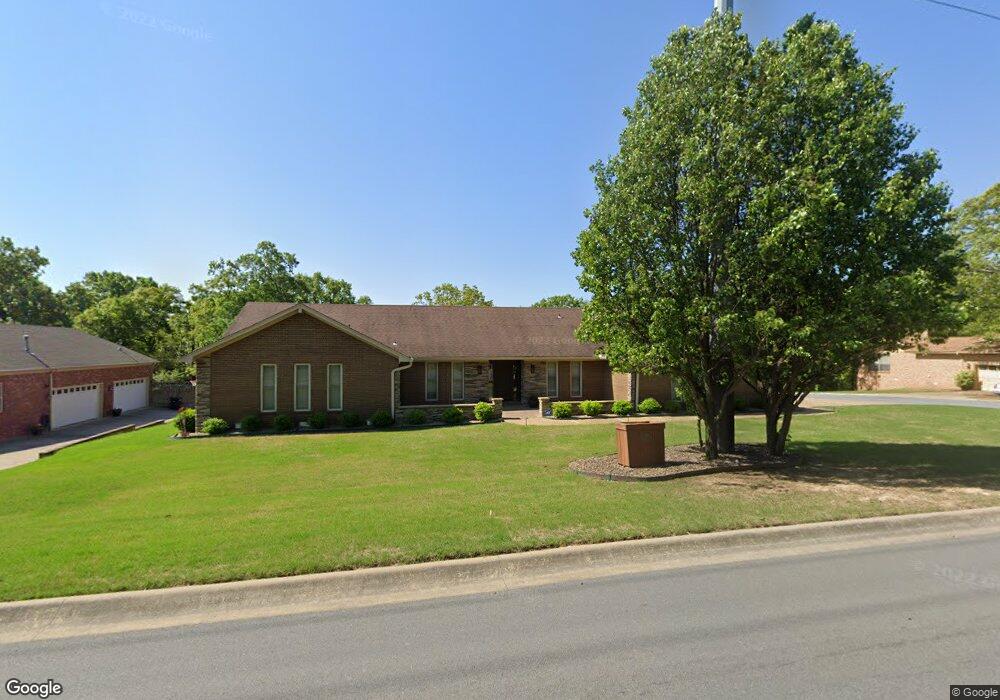
1100 Club Rd Sherwood, AR 72120
Estimated Value: $334,571 - $431,000
--
Bed
2
Baths
3,330
Sq Ft
$108/Sq Ft
Est. Value
About This Home
This home is located at 1100 Club Rd, Sherwood, AR 72120 and is currently estimated at $360,393, approximately $108 per square foot. 1100 Club Rd is a home located in Pulaski County with nearby schools including Sherwood Elementary School, Sylvan Hills Middle School, and Sylvan Hills High School.
Ownership History
Date
Name
Owned For
Owner Type
Purchase Details
Closed on
Nov 17, 2021
Sold by
Pedersen Dare and Pedersen Paula
Bought by
Pedersen Dare and Pedersen Paula
Current Estimated Value
Purchase Details
Closed on
Apr 19, 2006
Sold by
Shirley Danny N and Shirley Laural B
Bought by
Pederson Dane and Pederson Paula
Home Financials for this Owner
Home Financials are based on the most recent Mortgage that was taken out on this home.
Original Mortgage
$235,000
Interest Rate
6.33%
Mortgage Type
Purchase Money Mortgage
Purchase Details
Closed on
Jan 3, 2006
Sold by
Shirley Linda P
Bought by
Shirley Linda P
Purchase Details
Closed on
Sep 30, 2005
Sold by
Lunn Harry T and Lunn Louanna F
Bought by
Shirley Linda
Home Financials for this Owner
Home Financials are based on the most recent Mortgage that was taken out on this home.
Original Mortgage
$100,000
Interest Rate
5.28%
Mortgage Type
Fannie Mae Freddie Mac
Create a Home Valuation Report for This Property
The Home Valuation Report is an in-depth analysis detailing your home's value as well as a comparison with similar homes in the area
Home Values in the Area
Average Home Value in this Area
Purchase History
| Date | Buyer | Sale Price | Title Company |
|---|---|---|---|
| Pedersen Dare | -- | None Listed On Document | |
| Pederson Dane | $235,000 | American Abstract & Title Co | |
| Shirley Linda P | -- | -- | |
| Shirley Linda | $185,000 | Lenders Title Co |
Source: Public Records
Mortgage History
| Date | Status | Borrower | Loan Amount |
|---|---|---|---|
| Previous Owner | Pederson Dane | $235,000 | |
| Previous Owner | Shirley Linda | $100,000 |
Source: Public Records
Tax History Compared to Growth
Tax History
| Year | Tax Paid | Tax Assessment Tax Assessment Total Assessment is a certain percentage of the fair market value that is determined by local assessors to be the total taxable value of land and additions on the property. | Land | Improvement |
|---|---|---|---|---|
| 2025 | $2,638 | $57,463 | $6,600 | $50,863 |
| 2024 | $2,418 | $57,463 | $6,600 | $50,863 |
| 2023 | $2,418 | $57,463 | $6,600 | $50,863 |
| 2022 | $2,603 | $57,463 | $6,600 | $50,863 |
| 2021 | $2,402 | $42,200 | $6,000 | $36,200 |
| 2020 | $2,399 | $42,200 | $6,000 | $36,200 |
| 2019 | $2,399 | $42,200 | $6,000 | $36,200 |
| 2018 | $2,399 | $42,200 | $6,000 | $36,200 |
| 2017 | $2,399 | $42,200 | $6,000 | $36,200 |
| 2016 | $2,239 | $39,140 | $6,600 | $32,540 |
| 2015 | $1,988 | $39,140 | $6,600 | $32,540 |
| 2014 | $1,988 | $39,140 | $6,600 | $32,540 |
Source: Public Records
Map
Nearby Homes
- 4636 Brandywine Cove
- 11 Daniel Dr
- 8000 Pinto Trail
- +/- 8.16 Acres Windchime Ave
- 701 Club Rd
- 8320 Holiday Dr
- 1800 Palomino Dr
- 1301 Stafford Rd
- 1300 Stafford Rd
- 619 Newcastle Dr
- 1415 Stafford Rd
- 609 Newcastle Dr
- 626 Newcastle Dr
- 622 Newcastle Dr
- 618 & 620 Newcastle Dr
- 1419 Stafford Rd
- 610 Newcastle Dr
- 1423 Stafford Rd
- 615 & 617 Brierly Dr
- 615 Brierly Dr