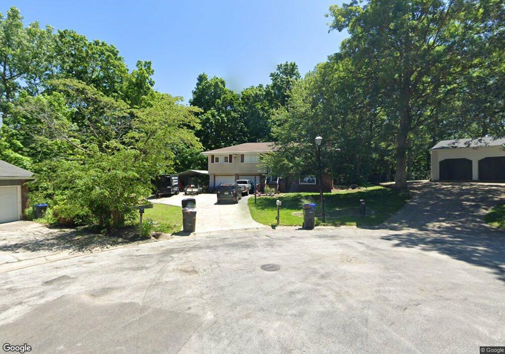
1100 Del-Scott Ct Mount Zion, IL 62549
Estimated Value: $248,000 - $258,645
3
Beds
3
Baths
2,419
Sq Ft
$104/Sq Ft
Est. Value
About This Home
This home is located at 1100 Del-Scott Ct, Mount Zion, IL 62549 and is currently estimated at $252,411, approximately $104 per square foot. 1100 Del-Scott Ct is a home located in Macon County with nearby schools including McGaughey Elementary School, Mt. Zion Elementary School, and Mt. Zion Intermediate School.
Ownership History
Date
Name
Owned For
Owner Type
Purchase Details
Closed on
Jul 23, 2021
Sold by
Ballweg Alex
Bought by
Koestler Gary E and Koestler Patrica A
Current Estimated Value
Home Financials for this Owner
Home Financials are based on the most recent Mortgage that was taken out on this home.
Original Mortgage
$187,000
Outstanding Balance
$168,963
Interest Rate
2.63%
Mortgage Type
VA
Estimated Equity
$83,448
Purchase Details
Closed on
Mar 16, 2012
Sold by
Hadden D Kent and Hadden Kathy J
Bought by
Ballweg Alex
Home Financials for this Owner
Home Financials are based on the most recent Mortgage that was taken out on this home.
Original Mortgage
$126,000
Interest Rate
3.88%
Mortgage Type
New Conventional
Purchase Details
Closed on
Jun 1, 1990
Create a Home Valuation Report for This Property
The Home Valuation Report is an in-depth analysis detailing your home's value as well as a comparison with similar homes in the area
Home Values in the Area
Average Home Value in this Area
Purchase History
| Date | Buyer | Sale Price | Title Company |
|---|---|---|---|
| Koestler Gary E | $187,000 | None Available | |
| Ballweg Alex | $157,500 | None Available | |
| -- | $72,900 | -- |
Source: Public Records
Mortgage History
| Date | Status | Borrower | Loan Amount |
|---|---|---|---|
| Open | Koestler Gary E | $187,000 | |
| Previous Owner | Ballweg Alex | $126,000 |
Source: Public Records
Tax History Compared to Growth
Tax History
| Year | Tax Paid | Tax Assessment Tax Assessment Total Assessment is a certain percentage of the fair market value that is determined by local assessors to be the total taxable value of land and additions on the property. | Land | Improvement |
|---|---|---|---|---|
| 2024 | -- | $69,546 | $8,470 | $61,076 |
| 2023 | -- | $64,682 | $7,878 | $56,804 |
| 2022 | $0 | $61,351 | $7,472 | $53,879 |
| 2021 | $4,441 | $57,475 | $7,000 | $50,475 |
| 2020 | $3,896 | $51,691 | $8,114 | $43,577 |
| 2019 | $3,896 | $51,691 | $8,114 | $43,577 |
| 2018 | $3,774 | $50,371 | $7,907 | $42,464 |
| 2017 | $4,235 | $49,403 | $7,755 | $41,648 |
| 2016 | $4,201 | $48,544 | $7,620 | $40,924 |
| 2015 | $4,067 | $48,064 | $7,545 | $40,519 |
| 2014 | $3,921 | $48,064 | $7,545 | $40,519 |
| 2013 | $3,966 | $48,064 | $7,545 | $40,519 |
Source: Public Records
Map
Nearby Homes
- 1610 Robin Ct
- 925 S Wildwood Dr
- 860 W Wildwood Dr
- 50 Sundance Dr
- 570 Fawn Ct
- 1820 Buckhead Ln
- 2125 Buckhead Ave
- 2130 Buckhead Ave
- 2110 Buckhead Ln
- 1935 Buckhead Ct
- 2020 Buckhead Ln
- 3330 S Baltimore Ave
- 3930 S Mount Zion Rd
- 2030 Buckhead Ln
- 1440 N Alexander Dr
- 265 Carrington Ave
- 125 W Walnut St
- 820 Kirk Dr
- 524 Elm St
- 400 Maddox Dr
- 1100 Del Scott Ct
- 1105 Del Scott Ct
- 1105 Del-Scott Ct
- 1110 Del-Scott Ct
- 1115 Del Scott Ct
- 1110 Rosewood Dr
- 1120 Del Scott Ct
- 1125 Del-Scott Ct
- 1125 Del Scott Ct
- 1120 Del-Scott Ct
- 1620 Robin Ct
- 1130 Rosewood Dr
- 1010 Rosewood Dr
- 1135 Del Scott Ct
- 1130 Del-Scott Ct
- 1135 Del-Scott Ct
- 1130 Del Scott Ct
- 1140 Rosewood Dr
- 1640 Robin Ct
- 1150 Rosewood Dr