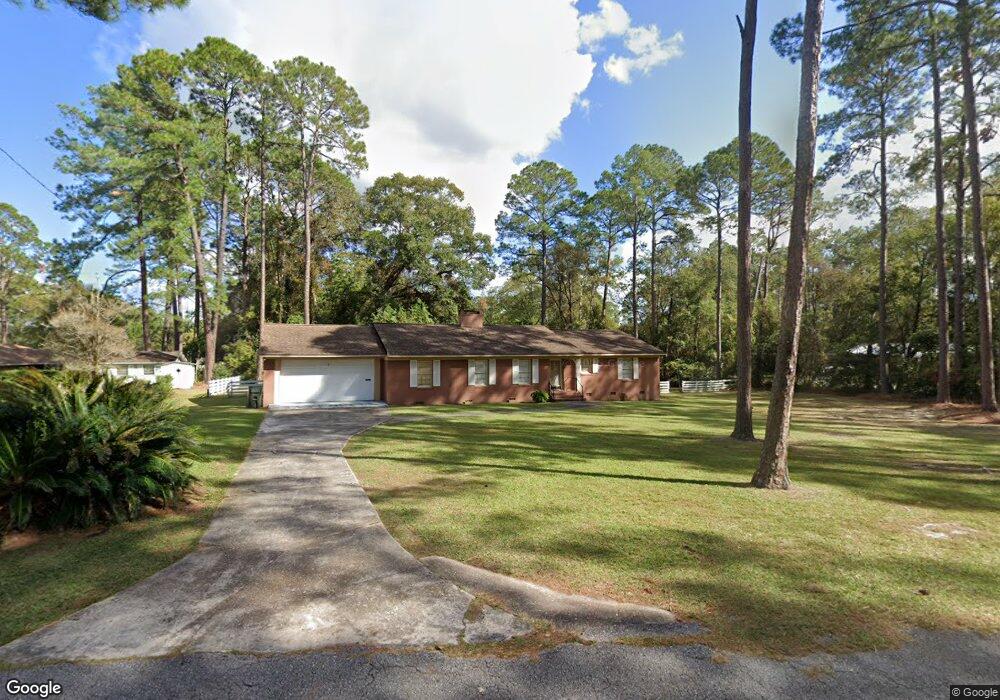
1100 Suwanne Dr Waycross, GA 31501
Estimated Value: $207,000 - $251,000
3
Beds
3
Baths
2,420
Sq Ft
$97/Sq Ft
Est. Value
About This Home
This home is located at 1100 Suwanne Dr, Waycross, GA 31501 and is currently estimated at $234,104, approximately $96 per square foot. 1100 Suwanne Dr is a home located in Ware County with nearby schools including Williams Heights Elementary School, Waycross Middle School, and Ware County High School.
Ownership History
Date
Name
Owned For
Owner Type
Purchase Details
Closed on
Jun 22, 2001
Sold by
Collins Robert M and Collins E
Bought by
Pearce Stephen H and Pearce Deborah S
Current Estimated Value
Purchase Details
Closed on
Sep 23, 1998
Sold by
Register Kathy L
Bought by
Collins Robert M and Collins E
Purchase Details
Closed on
Aug 29, 1994
Bought by
Register Kathy L
Purchase Details
Closed on
Nov 11, 1992
Bought by
Lastinger Edwin C
Create a Home Valuation Report for This Property
The Home Valuation Report is an in-depth analysis detailing your home's value as well as a comparison with similar homes in the area
Purchase History
| Date | Buyer | Sale Price | Title Company |
|---|---|---|---|
| Pearce Stephen H | $121,000 | -- | |
| Collins Robert M | $125,000 | -- | |
| Register Kathy L | $69,500 | -- | |
| Lastinger Edwin C | $59,900 | -- |
Source: Public Records
Tax History
| Year | Tax Paid | Tax Assessment Tax Assessment Total Assessment is a certain percentage of the fair market value that is determined by local assessors to be the total taxable value of land and additions on the property. | Land | Improvement |
|---|---|---|---|---|
| 2025 | $2,388 | $82,987 | $11,840 | $71,147 |
| 2024 | $2,388 | $82,987 | $11,840 | $71,147 |
| 2023 | $2,437 | $70,501 | $6,532 | $63,969 |
| 2022 | $2,480 | $70,501 | $6,532 | $63,969 |
| 2021 | $2,346 | $59,127 | $6,532 | $52,595 |
| 2020 | $2,290 | $56,521 | $6,532 | $49,989 |
| 2019 | $2,210 | $52,612 | $6,532 | $46,080 |
| 2018 | $2,184 | $50,983 | $6,532 | $44,451 |
| 2017 | $2,131 | $50,983 | $6,532 | $44,451 |
| 2016 | $2,131 | $50,983 | $6,532 | $44,451 |
| 2015 | $2,146 | $50,983 | $6,532 | $44,451 |
| 2014 | $2,144 | $50,983 | $6,532 | $44,451 |
| 2013 | -- | $71,730 | $6,532 | $65,197 |
Source: Public Records
Map
Nearby Homes
- 805 Baltimore Ave
- 713 Magnolia Dr
- 808 Euclid Ave
- 1205 Dean Dr
- 1100 Atlantic Ave
- 800 Euclid Ave
- 907 Euclid Ave
- 0 Saint Marys Dr Unit (TRACT 2 0.25 ACRES)
- 1009 Euclid Ave
- 1100 Euclid Ave
- 707 Euclid Ave
- 7438 Central Ave
- 1001 Coral Rd
- 1500 Saint Marys Dr
- 808 Satilla Blvd
- 1204 Richmond Ave
- 511 Richmond Ave
- 807 City Blvd
- 901 City Blvd
- 506 Magnolia Dr
- 1506 Suwanee Dr
- 907 Richmond Ave
- 1108 Suwanne Dr
- 00 Richmond Ave
- 00 Richmond Ave
- 902 Richmond Ave
- 1008 Suwanne Dr
- 1008 Suwanee Dr
- 1101 Suwanne Dr
- 910 Baltimore Ave
- 909 Richmond Ave
- 906 Richmond Ave
- 1101 Suwanne Dr
- 810 Richmond Ave
- 1105 Suwanne Dr
- 908 Richmond Ave
- 914 Baltimore Ave
- 1405 Suwanee Dr
- 1709 Suwanee Dr
- 1507 Suwanee Dr