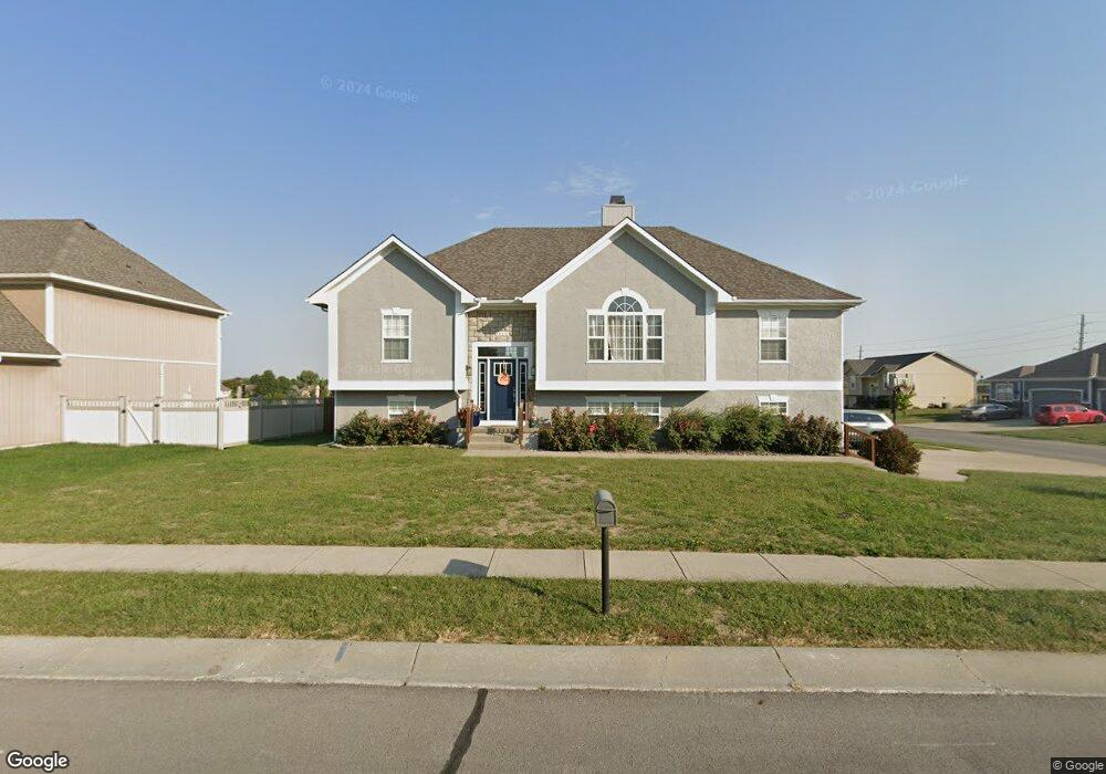
1100 SW 10th St Oak Grove, MO 64075
Estimated Value: $353,527 - $407,000
4
Beds
3
Baths
1,670
Sq Ft
$223/Sq Ft
Est. Value
About This Home
This home is located at 1100 SW 10th St, Oak Grove, MO 64075 and is currently estimated at $372,632, approximately $223 per square foot. 1100 SW 10th St is a home located in Jackson County with nearby schools including Oak Grove Primary School, Oak Grove Elementary School, and Oak Grove Middle School.
Ownership History
Date
Name
Owned For
Owner Type
Purchase Details
Closed on
Jun 5, 2018
Sold by
Beerbaur Stephen
Bought by
Beerbaur Holly
Current Estimated Value
Home Financials for this Owner
Home Financials are based on the most recent Mortgage that was taken out on this home.
Original Mortgage
$191,500
Outstanding Balance
$164,863
Interest Rate
4.3%
Mortgage Type
New Conventional
Estimated Equity
$207,769
Purchase Details
Closed on
Dec 22, 2006
Sold by
Shome Homes Llc
Bought by
Beerbaur Stephen and Beerbaur Holly
Create a Home Valuation Report for This Property
The Home Valuation Report is an in-depth analysis detailing your home's value as well as a comparison with similar homes in the area
Home Values in the Area
Average Home Value in this Area
Purchase History
| Date | Buyer | Sale Price | Title Company |
|---|---|---|---|
| Beerbaur Holly | -- | Kansas City Title | |
| Beerbaur Stephen | -- | None Available |
Source: Public Records
Mortgage History
| Date | Status | Borrower | Loan Amount |
|---|---|---|---|
| Open | Beerbaur Holly | $191,500 |
Source: Public Records
Tax History Compared to Growth
Tax History
| Year | Tax Paid | Tax Assessment Tax Assessment Total Assessment is a certain percentage of the fair market value that is determined by local assessors to be the total taxable value of land and additions on the property. | Land | Improvement |
|---|---|---|---|---|
| 2025 | $5,048 | $64,327 | $10,000 | $54,327 |
| 2024 | $5,000 | $64,980 | $6,806 | $58,174 |
| 2023 | $5,000 | $64,980 | $8,305 | $56,675 |
| 2022 | $4,100 | $48,640 | $8,683 | $39,957 |
| 2021 | $4,011 | $48,640 | $8,683 | $39,957 |
| 2020 | $3,915 | $46,256 | $8,683 | $37,573 |
| 2019 | $3,725 | $46,256 | $8,683 | $37,573 |
| 2018 | $1,737,607 | $42,228 | $5,951 | $36,277 |
| 2017 | $3,241 | $42,228 | $5,951 | $36,277 |
| 2016 | $3,141 | $39,672 | $8,664 | $31,008 |
| 2014 | $3,049 | $38,399 | $8,662 | $29,737 |
Source: Public Records
Map
Nearby Homes
- 1001 SW Powell Dr
- 1106 SW 10th St
- 1112 SW 10th St
- 708 SW Whitetail Dr
- 1202 SW Cardinal Ct
- 400 SW Powell Dr
- 1212 SW 5th St
- The Aspen Plan at Oaks of Edgewood
- The Stratford Plan at Oaks of Edgewood
- The Brookfield Plan at Oaks of Edgewood
- The Marceline Plan at Oaks of Edgewood
- 901 SW Redbird Ct
- 903 SW Redbird Ct
- 1201 SW 4th St
- 900 SW Redbird Ct
- 902 SW Redbird Ct
- 904 SW Redbird Ct
- Lot 19 TBD SE Holstein Dr
- 1502 SW Meadowlark Ct
- Riverside Plan at Oaks of Edgewood
- 1100 SW 10 St
- 1102 SW 10th St
- 908 SW Powell Dr
- 1000 SW Powell Dr
- 913 SW Powell Dr
- 1104 SW 10th St
- 911 SW Powell Dr
- 1001 SW Redbud Cir
- 906 SW Powell Dr
- 909 SW Powell Dr
- 1002 SW Powell Dr
- 1003 SW Redbud Cir
- 907 SW Powell Dr
- 1003 SW Powell Dr
- 904 SW Powell Dr
- 1000 SW Redbud Cir
- 1004 SW Powell Dr
- 1108 SW 10th St
- 1005 SW Powell Dr
- 905 SW Powell Dr