Estimated Value: $87,000 - $369,000
3
Beds
2
Baths
1,562
Sq Ft
$119/Sq Ft
Est. Value
About This Home
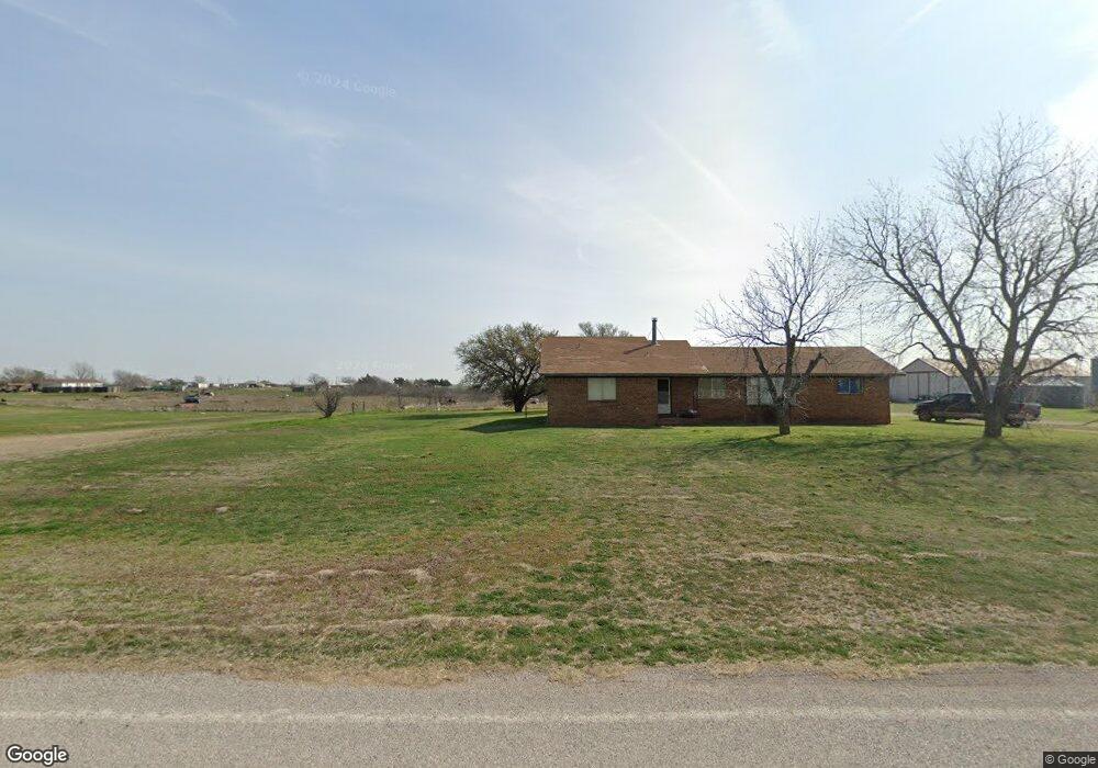
This home is located at 1100 Wichita Ave, Devol, OK 73531 and is currently estimated at $185,594, approximately $118 per square foot. 1100 Wichita Ave is a home located in Cotton County with nearby schools including Big Pasture Elementary School and Big Pasture High School.
Ownership History
Date
Name
Owned For
Owner Type
Purchase Details
Closed on
May 20, 2009
Sold by
Liberty National Bank N A
Bought by
Wilson Samuel James and Wilson Vickie L
Current Estimated Value
Purchase Details
Closed on
Dec 18, 2007
Sold by
Mcmenamin Teresa Jean
Bought by
Mcmenamin Jerry Wayne
Purchase Details
Closed on
Oct 10, 2006
Sold by
M & S Construction Management
Bought by
Castillo Linda
Home Financials for this Owner
Home Financials are based on the most recent Mortgage that was taken out on this home.
Original Mortgage
$108,000
Interest Rate
6.41%
Mortgage Type
New Conventional
Create a Home Valuation Report for This Property
The Home Valuation Report is an in-depth analysis detailing your home's value as well as a comparison with similar homes in the area
Home Values in the Area
Average Home Value in this Area
Purchase History
| Date | Buyer | Sale Price | Title Company |
|---|---|---|---|
| Wilson Samuel James | $25,500 | None Available | |
| Mcmenamin Jerry Wayne | -- | None Available | |
| Castillo Linda | $135,000 | Ward Title & Closing Company |
Source: Public Records
Mortgage History
| Date | Status | Borrower | Loan Amount |
|---|---|---|---|
| Previous Owner | Castillo Linda | $108,000 |
Source: Public Records
Tax History Compared to Growth
Tax History
| Year | Tax Paid | Tax Assessment Tax Assessment Total Assessment is a certain percentage of the fair market value that is determined by local assessors to be the total taxable value of land and additions on the property. | Land | Improvement |
|---|---|---|---|---|
| 2025 | $695 | $7,756 | $573 | $7,183 |
| 2024 | $695 | $7,857 | $573 | $7,284 |
| 2023 | $695 | $7,857 | $573 | $7,284 |
| 2022 | $677 | $7,611 | $573 | $7,038 |
| 2021 | $649 | $7,249 | $573 | $6,676 |
| 2020 | $620 | $6,904 | $573 | $6,331 |
| 2019 | $589 | $6,575 | $573 | $6,002 |
| 2018 | $475 | $6,262 | $573 | $5,689 |
| 2017 | $450 | $6,080 | $573 | $5,507 |
| 2016 | $428 | $5,903 | $573 | $5,330 |
| 2015 | $423 | $5,731 | $573 | $5,158 |
| 2014 | $410 | $5,564 | $573 | $4,991 |
Source: Public Records
Map
Nearby Homes
- 199359 Oklahoma 36
- TBD Mulberry St
- 245920 E County Road 1950
- 246578 E 1970 Rd
- 248464 E 1984 Ln
- 2222 Vaughn Rd
- 2182 Vaughn Rd
- 3396 River Bottom Rd
- 501 S Main St
- 278 AC River Bottom Rd
- 1479 Holman Rd
- 317 E 7th St
- 801 N Avenue C
- 132 N Avenue F
- 130 N Avenue F
- 623 W 4th St
- 301 S Stinson Ave
- 601 Floyd St
- 617 E 3rd St
- 601 E 3rd St
- 1100 Wichita Ave
- 1100 Wichita Ave
- 1100 Wichita Ave
- 407 Wichita Ave
- 409 Wichita Ave
- 104 Mulberry Rd
- 182352 N 2800 Rd
- 106 E Catalpa St
- 701 Wichita Ave
- 000 Highway 70 E
- 1115 Enid Ave
- 112 Maple St
- 808 Altus
- 611 Wichita Ave
- 199154 Highway 36
- 611 Wichita Ave
- 197499 N 2490 Rd
- 247731 E 1970 Rd
- 513 Hobart St
- 208 Poplar St