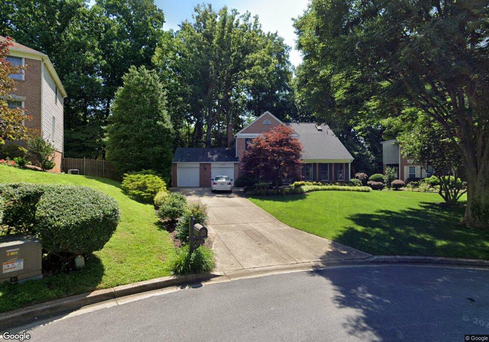
11005 Petersborough Dr Rockville, MD 20852
Estimated Value: $1,189,000 - $1,494,000
--
Bed
4
Baths
2,622
Sq Ft
$524/Sq Ft
Est. Value
About This Home
This home is located at 11005 Petersborough Dr, Rockville, MD 20852 and is currently estimated at $1,375,110, approximately $524 per square foot. 11005 Petersborough Dr is a home located in Montgomery County with nearby schools including Garrett Park Elementary School, Tilden Middle School, and Walter Johnson High School.
Ownership History
Date
Name
Owned For
Owner Type
Purchase Details
Closed on
Aug 28, 2009
Sold by
Vashio Valerie A
Bought by
Vashio Valerie Ann
Current Estimated Value
Purchase Details
Closed on
Oct 14, 2004
Sold by
Sutherl
Bought by
Vashio Valerie A
Purchase Details
Closed on
Nov 20, 1995
Sold by
H Paul V and H Oconnell K
Bought by
Sutherland Marjorie A and Sutherland Smith
Create a Home Valuation Report for This Property
The Home Valuation Report is an in-depth analysis detailing your home's value as well as a comparison with similar homes in the area
Home Values in the Area
Average Home Value in this Area
Purchase History
| Date | Buyer | Sale Price | Title Company |
|---|---|---|---|
| Vashio Valerie Ann | -- | -- | |
| Vashio Valerie A | $866,000 | -- | |
| Vashio Valerie A | $866,000 | -- | |
| Sutherland Marjorie A | $456,500 | -- |
Source: Public Records
Tax History Compared to Growth
Tax History
| Year | Tax Paid | Tax Assessment Tax Assessment Total Assessment is a certain percentage of the fair market value that is determined by local assessors to be the total taxable value of land and additions on the property. | Land | Improvement |
|---|---|---|---|---|
| 2025 | $639 | $1,233,433 | -- | -- |
| 2024 | $639 | $1,151,700 | $553,300 | $598,400 |
| 2023 | $606 | $1,095,667 | $0 | $0 |
| 2022 | $8,379 | $1,039,633 | $0 | $0 |
| 2021 | $10,684 | $983,600 | $526,900 | $456,700 |
| 2020 | $10,633 | $981,200 | $0 | $0 |
| 2019 | $10,579 | $978,800 | $0 | $0 |
| 2018 | $10,559 | $976,400 | $526,900 | $449,500 |
| 2017 | $10,375 | $949,933 | $0 | $0 |
| 2016 | $9,062 | $923,467 | $0 | $0 |
| 2015 | $9,062 | $897,000 | $0 | $0 |
| 2014 | $9,062 | $870,833 | $0 | $0 |
Source: Public Records
Map
Nearby Homes
- 11117 Waycroft Way
- 5506 Edson Ln
- 5704 Mossrock Dr
- 11204 Edson Park Place Unit 8
- 11204 Edson Park Place Unit 7
- 10940 Brewer House Rd
- 5601 Whitney Mill Way
- 11322 Hollowstone Dr
- 10906 Wickshire Way
- 11008 Wickshire Way
- 5705 Chapman Mill Dr Unit 200
- 11420 Strand Dr
- 11503 Ridgerock Ln
- 10831 Luxberry Dr
- 5801 Inman Park Cir Unit 170
- 5804 Inman Park Cir Unit 340
- 5800 Nicholson Ln
- 5800 Nicholson Ln
- 5919 Barbados Place Unit 202
- 10713 Hampton Mill Terrace Unit 311
- 11001 Petersborough Dr
- 11009 Petersborough Dr
- 5614 Sugarbush Ln
- 5616 Sugarbush Ln
- 5612 Sugarbush Ln
- 11000 Petersborough Dr
- 5618 Sugarbush Ln
- 11101 Snowshoe Ln
- 11003 Sugarbush Terrace
- 5608 Sugarbush Ln
- 11006 Petersborough Dr
- 11004 Petersborough Dr
- 11005 Sugarbush Terrace
- 5620 Sugarbush Ln
- 11049 Snowshoe Ln
- 11105 Snowshoe Ln
- 5617 Sugarbush Ln
- 5619 Sugarbush Ln
- 11004 Sugarbush Terrace
- 11001 Sugarbush Terrace