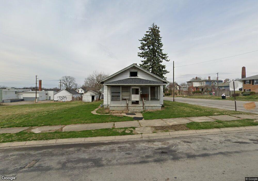
1101 Pine St Springfield, OH 45505
Estimated Value: $83,000 - $127,000
3
Beds
1
Bath
1,008
Sq Ft
$104/Sq Ft
Est. Value
About This Home
This home is located at 1101 Pine St, Springfield, OH 45505 and is currently estimated at $104,443, approximately $103 per square foot. 1101 Pine St is a home located in Clark County with nearby schools including Kenwood Elementary School, Hayward Middle School, and Springfield High School.
Ownership History
Date
Name
Owned For
Owner Type
Purchase Details
Closed on
Feb 25, 2022
Sold by
Rigsby Shawn A
Bought by
Karg Christopher and Karg Stephanie
Current Estimated Value
Purchase Details
Closed on
Jun 29, 2020
Sold by
Estate Of Elin M Rigsby
Bought by
Rigsby Shawn A
Purchase Details
Closed on
Oct 26, 2007
Sold by
Hsbc Bank Usa Na
Bought by
Estes Cloye and Rigsby Elin
Purchase Details
Closed on
Apr 13, 2007
Sold by
Blair Richard A
Bought by
Hsbc Bank Usa Na and Ace Securities Corp Home Equity Loan Tr
Purchase Details
Closed on
Oct 1, 1979
Sold by
Graham Thelma K
Bought by
Blair Richard A and Blair Patricia
Create a Home Valuation Report for This Property
The Home Valuation Report is an in-depth analysis detailing your home's value as well as a comparison with similar homes in the area
Home Values in the Area
Average Home Value in this Area
Purchase History
| Date | Buyer | Sale Price | Title Company |
|---|---|---|---|
| Karg Christopher | $7,500 | Ohio Real Estate Title | |
| Rigsby Shawn A | -- | None Available | |
| Estes Cloye | $9,000 | Titlequest Agency | |
| Hsbc Bank Usa Na | $23,334 | Attorney | |
| Blair Richard A | $35,000 | -- |
Source: Public Records
Tax History
| Year | Tax Paid | Tax Assessment Tax Assessment Total Assessment is a certain percentage of the fair market value that is determined by local assessors to be the total taxable value of land and additions on the property. | Land | Improvement |
|---|---|---|---|---|
| 2025 | $852 | $25,060 | $3,150 | $21,910 |
| 2024 | $2,830 | $16,820 | $2,470 | $14,350 |
| 2023 | $1,830 | $16,820 | $2,470 | $14,350 |
| 2022 | $1,319 | $16,820 | $2,470 | $14,350 |
| 2021 | $844 | $15,350 | $2,250 | $13,100 |
| 2020 | $845 | $15,350 | $2,250 | $13,100 |
| 2019 | $848 | $15,350 | $2,250 | $13,100 |
| 2018 | $783 | $13,620 | $1,870 | $11,750 |
| 2017 | $783 | $13,626 | $1,873 | $11,753 |
| 2016 | $784 | $13,626 | $1,873 | $11,753 |
| 2015 | $799 | $13,626 | $1,873 | $11,753 |
| 2014 | $796 | $13,626 | $1,873 | $11,753 |
| 2013 | $787 | $13,626 | $1,873 | $11,753 |
Source: Public Records
Map
Nearby Homes
- 1111 Lafayette Ave
- 908 Pine St
- 652 E Southern Ave
- 1005 Burt St
- 900 E Rose St
- 453 E Pleasant St
- 1440 Selma Rd
- 1008 Tibbetts Ave
- 718 Summer St
- 705 York St
- 550 E Rose St
- 1225 Beacon St
- 1652 Kenton St
- 625 Tibbetts Ave
- 441 E Euclid Ave
- 1714 Kenton St
- 1065 Mound St Unit 1067
- 360 S Greenmount Ave
- 1609 Irwin Ave
- 321 Glenn Ave
- 1027 Pine St
- 1002 Oak St
- 1006 Oak St
- 1010 Oak St
- 1056 Buckeye St
- 1108 Pine St
- 1106 Selma Rd
- 1102 Selma Rd Unit 1104
- 1112 Selma Rd Unit 1114
- 1110 Pine St Unit 1112
- 1028 Pine St
- 950 Oak St
- 1000 Selma Rd
- 1013 Pine St
- 946 Oak St Unit 948
- 1156 Selma Rd
- 1160 Selma Rd
- 1005 Pine St Unit 1007
- 1014 Pine St
- 1164 Selma Rd
Your Personal Tour Guide
Ask me questions while you tour the home.