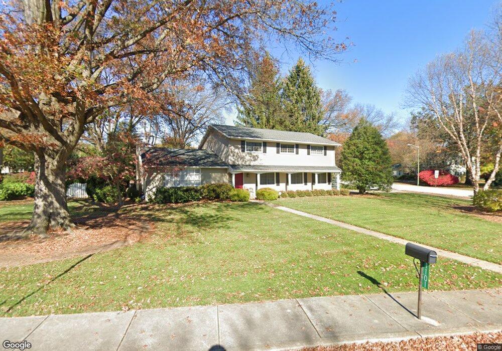
1101 Stratford Dr Carlisle, PA 17013
Estimated Value: $459,000 - $507,300
4
Beds
3
Baths
3,186
Sq Ft
$154/Sq Ft
Est. Value
About This Home
This home is located at 1101 Stratford Dr, Carlisle, PA 17013 and is currently estimated at $490,325, approximately $153 per square foot. 1101 Stratford Dr is a home located in Cumberland County with nearby schools including Mooreland Elementary School, Lamberton Middle School, and Carlisle Area High School.
Ownership History
Date
Name
Owned For
Owner Type
Purchase Details
Closed on
May 29, 2009
Sold by
Flenniken Neil A
Bought by
Lacquement Richard A
Current Estimated Value
Home Financials for this Owner
Home Financials are based on the most recent Mortgage that was taken out on this home.
Original Mortgage
$268,580
Outstanding Balance
$170,150
Interest Rate
4.82%
Mortgage Type
VA
Estimated Equity
$320,175
Create a Home Valuation Report for This Property
The Home Valuation Report is an in-depth analysis detailing your home's value as well as a comparison with similar homes in the area
Home Values in the Area
Average Home Value in this Area
Purchase History
| Date | Buyer | Sale Price | Title Company |
|---|---|---|---|
| Lacquement Richard A | $260,000 | -- |
Source: Public Records
Mortgage History
| Date | Status | Borrower | Loan Amount |
|---|---|---|---|
| Open | Lacquement Richard A | $268,580 |
Source: Public Records
Tax History Compared to Growth
Tax History
| Year | Tax Paid | Tax Assessment Tax Assessment Total Assessment is a certain percentage of the fair market value that is determined by local assessors to be the total taxable value of land and additions on the property. | Land | Improvement |
|---|---|---|---|---|
| 2025 | $6,193 | $263,000 | $71,800 | $191,200 |
| 2024 | $6,015 | $263,000 | $71,800 | $191,200 |
| 2023 | $5,741 | $263,000 | $71,800 | $191,200 |
| 2022 | $5,659 | $263,000 | $71,800 | $191,200 |
| 2021 | $5,578 | $263,000 | $71,800 | $191,200 |
| 2020 | $5,460 | $263,000 | $71,800 | $191,200 |
| 2019 | $5,346 | $263,000 | $71,800 | $191,200 |
| 2018 | $5,232 | $263,000 | $71,800 | $191,200 |
| 2017 | $5,128 | $263,000 | $71,800 | $191,200 |
| 2016 | -- | $263,000 | $71,800 | $191,200 |
| 2015 | -- | $263,000 | $71,800 | $191,200 |
| 2014 | -- | $263,000 | $71,800 | $191,200 |
Source: Public Records
Map
Nearby Homes
- 628 Belvedere St
- 808 Wellington Dr
- 500 Belvedere St
- 1003 Rockledge Dr
- 808 Walnut Ln
- 1322 Georgetown Cir
- 6 Rockledge Ct
- 250 Mooreland Ave
- 300 Acre Dr
- 229 Mooreland Ave
- 48 Strawberry Dr
- 124 Conway St
- Corby Plan at Grange - Single Family
- Ashby Plan at Grange - Single Family
- Darby Plan at Grange - Single Family
- Elgin Plan at Grange - Single Family
- Royston Plan at Grange - Single Family
- Dundee Plan at Grange - Single Family
- Anders Plan at Grange - Single Family
- Carter Plan at Grange - Single Family
- 1105 Stratford Dr
- 616 Sherwood Dr
- 623 Sherwood Dr
- 1100 Stratford Dr
- 1104 Fleetwood Dr
- 619 Sherwood Dr
- 1111 Stratford Dr
- 1106 Stratford Dr
- 1110 Fleetwood Dr
- 701 Sherwood Dr
- 1101 Regent Ct
- 648 Yorkshire Dr
- 1114 Fleetwood Dr
- 644 Yorkshire Dr
- 1116 Stratford Dr
- 705 Sherwood Dr
- 609 Sherwood Dr
- 1115 Stratford Dr
- 608 Sherwood Dr
- 700 Yorkshire Dr