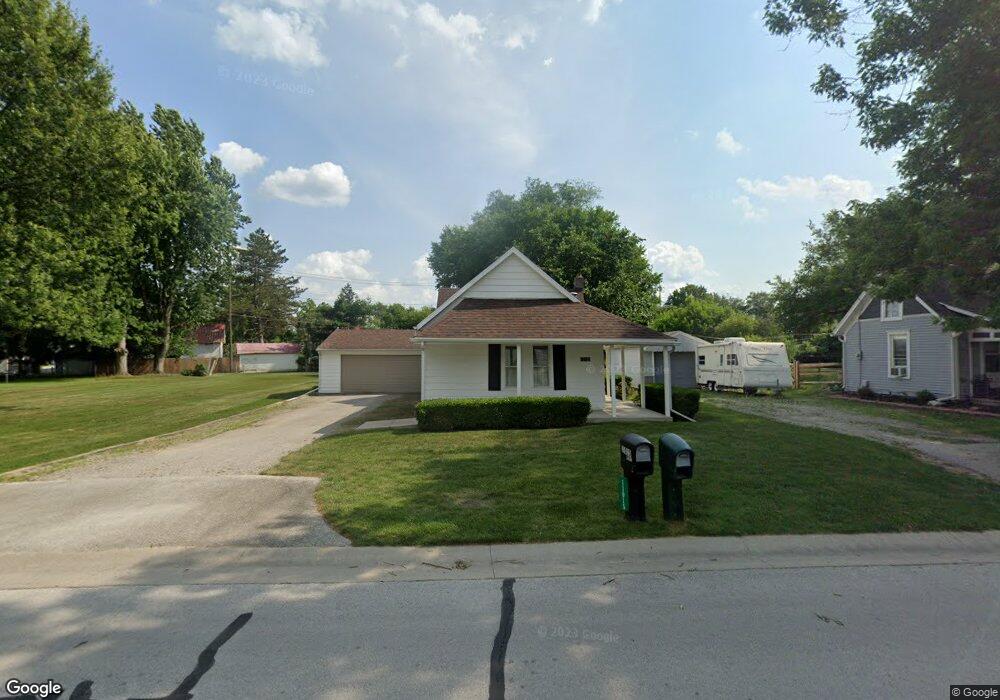
11015 West St Whitehouse, OH 43571
West Lucas County NeighborhoodEstimated Value: $196,983 - $217,000
3
Beds
1
Bath
1,258
Sq Ft
$164/Sq Ft
Est. Value
About This Home
This home is located at 11015 West St, Whitehouse, OH 43571 and is currently estimated at $205,996, approximately $163 per square foot. 11015 West St is a home located in Lucas County with nearby schools including Anthony Wayne High School and Lial Catholic School.
Ownership History
Date
Name
Owned For
Owner Type
Purchase Details
Closed on
Oct 17, 2000
Sold by
Raabe Richard S and Raabe Penney M
Bought by
Tenney Debra A
Current Estimated Value
Home Financials for this Owner
Home Financials are based on the most recent Mortgage that was taken out on this home.
Original Mortgage
$67,200
Outstanding Balance
$24,577
Interest Rate
7.96%
Estimated Equity
$181,419
Purchase Details
Closed on
Jan 16, 1990
Sold by
Reisch Raoul P
Create a Home Valuation Report for This Property
The Home Valuation Report is an in-depth analysis detailing your home's value as well as a comparison with similar homes in the area
Home Values in the Area
Average Home Value in this Area
Purchase History
| Date | Buyer | Sale Price | Title Company |
|---|---|---|---|
| Tenney Debra A | $84,000 | Northwest Title Agency Of Oh | |
| -- | $44,500 | -- |
Source: Public Records
Mortgage History
| Date | Status | Borrower | Loan Amount |
|---|---|---|---|
| Open | Tenney Debra A | $67,200 |
Source: Public Records
Tax History Compared to Growth
Tax History
| Year | Tax Paid | Tax Assessment Tax Assessment Total Assessment is a certain percentage of the fair market value that is determined by local assessors to be the total taxable value of land and additions on the property. | Land | Improvement |
|---|---|---|---|---|
| 2024 | $1,050 | $42,700 | $16,310 | $26,390 |
| 2023 | $2,361 | $43,365 | $12,075 | $31,290 |
| 2022 | $2,384 | $43,365 | $12,075 | $31,290 |
| 2021 | $2,574 | $43,365 | $12,075 | $31,290 |
| 2020 | $2,326 | $34,720 | $9,800 | $24,920 |
| 2019 | $2,155 | $34,720 | $9,800 | $24,920 |
| 2018 | $2,079 | $34,720 | $9,800 | $24,920 |
| 2017 | $2,113 | $31,535 | $12,005 | $19,530 |
| 2016 | $2,098 | $90,100 | $34,300 | $55,800 |
| 2015 | $2,017 | $90,100 | $34,300 | $55,800 |
| 2014 | $1,826 | $31,220 | $11,900 | $19,320 |
| 2013 | $1,826 | $31,220 | $11,900 | $19,320 |
Source: Public Records
Map
Nearby Homes
- 6316 Pimlico Rd
- 6547 Lenderson Ave
- 11149 West St
- 6935 Big Buck Trail
- 6715 Oakbrook Dr
- 6414 Lenderson Ave
- 11158 Whitetail Way
- 6951 Red Stag Ct
- 6952 Red Stag Ct
- 11159 Whitetail Way
- 7018 Red Stag Ct
- 6746 Oak Crossing Ln
- 11171 Whitetail Way
- 7002 Red Stag Ct
- 6306 Weckerly Rd
- 10751 Brexton Ct
- 10700 Brexton Ct
- 10706 Brexton Ct
- 10701 Brexton Ct
- 11500 Stiles Rd
- 11001 West St
- 11019 West St
- 11019 West St Unit AMBURG
- 10935 Maumee St
- 11014 West St
- 10956 Toledo St
- 11027 West St
- 10950 Toledo St
- 11004 West St
- 11020 West St
- 10942 Toledo St
- 11026 West St
- 6704 Swanton Rd
- 10960 Toledo St
- 10936 Toledo St
- 11032 West St
- 6656 N Texas St
- 10930 Toledo St
- 6651 Merritt St
- 5910 Waterville Swanton