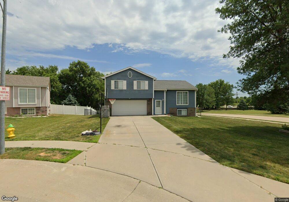
1102 Apache Cir Papillion, NE 68046
Estimated Value: $251,000 - $281,000
3
Beds
2
Baths
1,102
Sq Ft
$240/Sq Ft
Est. Value
About This Home
This home is located at 1102 Apache Cir, Papillion, NE 68046 and is currently estimated at $264,133, approximately $239 per square foot. 1102 Apache Cir is a home located in Sarpy County with nearby schools including Trumble Park Elementary School, Papillion Middle School, and Papillion La Vista South High School.
Ownership History
Date
Name
Owned For
Owner Type
Purchase Details
Closed on
Sep 13, 2000
Sold by
Celebrity Homes Inc
Bought by
Britten Robert S and Britten Heather E
Current Estimated Value
Home Financials for this Owner
Home Financials are based on the most recent Mortgage that was taken out on this home.
Original Mortgage
$123,518
Outstanding Balance
$44,731
Interest Rate
8.01%
Estimated Equity
$219,402
Create a Home Valuation Report for This Property
The Home Valuation Report is an in-depth analysis detailing your home's value as well as a comparison with similar homes in the area
Home Values in the Area
Average Home Value in this Area
Purchase History
| Date | Buyer | Sale Price | Title Company |
|---|---|---|---|
| Britten Robert S | $125,000 | -- |
Source: Public Records
Mortgage History
| Date | Status | Borrower | Loan Amount |
|---|---|---|---|
| Open | Britten Robert S | $123,518 |
Source: Public Records
Tax History
| Year | Tax Paid | Tax Assessment Tax Assessment Total Assessment is a certain percentage of the fair market value that is determined by local assessors to be the total taxable value of land and additions on the property. | Land | Improvement |
|---|---|---|---|---|
| 2025 | $3,388 | $247,600 | $44,000 | $203,600 |
| 2024 | $3,969 | $227,590 | $40,000 | $187,590 |
| 2023 | $3,969 | $210,804 | $35,000 | $175,804 |
| 2022 | $3,893 | $190,758 | $33,000 | $157,758 |
| 2021 | $3,557 | $170,859 | $29,000 | $141,859 |
| 2020 | $3,538 | $168,257 | $29,000 | $139,257 |
| 2019 | $3,290 | $156,555 | $27,000 | $129,555 |
| 2018 | $3,305 | $154,878 | $24,000 | $130,878 |
| 2017 | $3,184 | $149,239 | $22,000 | $127,239 |
| 2016 | $3,070 | $144,115 | $22,000 | $122,115 |
| 2015 | $2,906 | $136,831 | $22,000 | $114,831 |
| 2014 | $2,862 | $133,838 | $22,000 | $111,838 |
| 2012 | -- | $132,089 | $22,000 | $110,089 |
Source: Public Records
Map
Nearby Homes
- 919 Rawhide Rd
- 1114 Woodview Cir
- Lot 290 Pintail Dr
- LOT 58 Ashbury Hills
- Lot 130 Shadow Lake 2
- TBD S 98th St
- Lot 27 Terrace
- 907 Woodland Ave
- 1003 Valleyview Dr
- Lot 28 Ashbury Hills
- 259 Ashbury Hils St
- 12378 Lake Vista Dr
- 262 Ashbury Hills St
- 235 Lot St
- 613 Valley Rd
- 1104 Horseshoe Cir
- Lot 39
- Lot 52 Unit Lot 52
- 1806 Walnut Creek Dr
- 9801 Overland Trail
- 1104 Apache Cir
- 1302 Macarthur Dr
- 1304 Macarthur Dr
- 1220 Macarthur Dr
- 1106 Apache Cir
- 1108 Apache Cir
- 1218 Macarthur Dr
- 1101 Devon Dr
- 1105 Devon Dr
- 1216 Macarthur Dr
- 1007 Berkley Ave
- 1004 Devon Dr
- 1110 Devon Dr
- 1123 Palomino Cir
- 1107 Devon Dr
- 1006 Berkley Ave
- 1005 Devon Dr
- 1125 Palomino Cir
- 1214 Macarthur Dr
- 1005 Berkley Ave
Your Personal Tour Guide
Ask me questions while you tour the home.