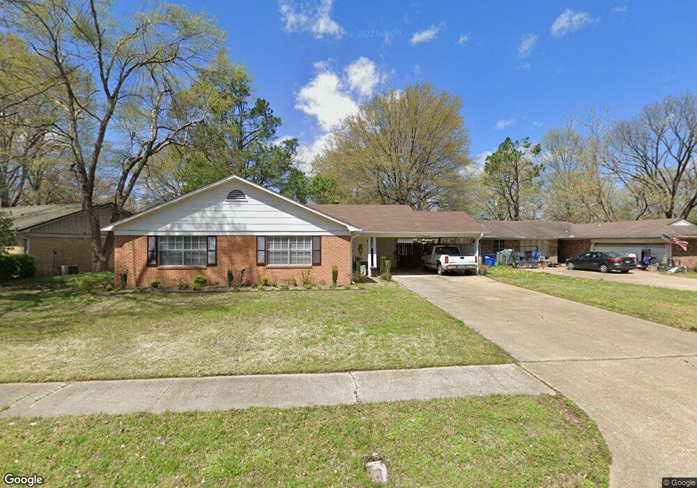
1102 Bridgeport St West Memphis, AR 72301
Estimated Value: $210,600 - $254,000
--
Bed
2
Baths
2,206
Sq Ft
$107/Sq Ft
Est. Value
About This Home
This home is located at 1102 Bridgeport St, West Memphis, AR 72301 and is currently estimated at $236,650, approximately $107 per square foot. 1102 Bridgeport St is a home located in Crittenden County with nearby schools including Richland Elementary School, West Junior High School, and The Academies of West Memphis Charter School.
Ownership History
Date
Name
Owned For
Owner Type
Purchase Details
Closed on
Apr 26, 2019
Sold by
Sullivan William R and Sullivan Leigh T
Bought by
Gray Perry and Gray Patsy
Current Estimated Value
Purchase Details
Closed on
Sep 20, 2011
Sold by
Lashlee William E
Bought by
Mallory Dorothy T
Purchase Details
Closed on
Aug 20, 2008
Sold by
Cartwright Glenda Dawne
Bought by
Cartwright David M
Purchase Details
Closed on
Jul 13, 2006
Sold by
Scott Robert W
Bought by
Lashlee William E
Purchase Details
Closed on
Sep 1, 1995
Sold by
Not Provided
Bought by
Murphy Tom and Murphy Susan
Purchase Details
Closed on
Mar 1, 1978
Bought by
To
Create a Home Valuation Report for This Property
The Home Valuation Report is an in-depth analysis detailing your home's value as well as a comparison with similar homes in the area
Home Values in the Area
Average Home Value in this Area
Purchase History
| Date | Buyer | Sale Price | Title Company |
|---|---|---|---|
| Gray Perry | $139,000 | None Available | |
| Mallory Dorothy T | -- | -- | |
| Cartwright David M | -- | -- | |
| Lashlee William E | -- | -- | |
| Murphy Tom | $93,000 | -- | |
| To | $42,000 | -- |
Source: Public Records
Tax History Compared to Growth
Tax History
| Year | Tax Paid | Tax Assessment Tax Assessment Total Assessment is a certain percentage of the fair market value that is determined by local assessors to be the total taxable value of land and additions on the property. | Land | Improvement |
|---|---|---|---|---|
| 2024 | $822 | $27,510 | $4,800 | $22,710 |
| 2023 | $897 | $27,510 | $4,800 | $22,710 |
| 2022 | $1,322 | $27,510 | $4,800 | $22,710 |
| 2021 | $1,322 | $27,510 | $4,800 | $22,710 |
| 2020 | $1,246 | $27,510 | $4,800 | $22,710 |
| 2019 | $959 | $25,370 | $4,600 | $20,770 |
| 2018 | $680 | $25,370 | $4,600 | $20,770 |
| 2017 | $680 | $25,370 | $4,600 | $20,770 |
| 2016 | $969 | $25,370 | $4,600 | $20,770 |
| 2015 | $690 | $25,370 | $4,600 | $20,770 |
| 2014 | $806 | $28,230 | $4,800 | $23,430 |
Source: Public Records
Map
Nearby Homes
- 1102 Bridgeport Dr
- 906 N Roselawn Dr
- 1105 Cherry Ln
- 808 Dover Rd
- 910 Richland Dr
- 817 Dover Rd
- 1301 Crestmere St
- 813 Pryor Dr
- 823 S Roselawn Dr
- 1113 Spears St
- 1010 Richland Dr
- 1203 W Roselawn Dr
- 1042 W Roselawn Dr
- 1017 Mayberry Cove
- 909 Rosewood Dr
- 613 Dover Rd
- 1012 Clement Rd
- 1010 Clement Rd
- 603 Highland Dr
- 807 W Barton Ave
- 1104 Bridgeport St
- 1100 Bridgeport Dr
- 819 Arlington Dr
- 1100 Bridgeport St
- 1106 Bridgeport St
- 1106 Bridgeport Dr
- 1103 Bridgeport Dr
- 1101 Bridgeport St
- 901 Arlington Dr
- 1105 Bridgeport St
- 822 N Roselawn Dr
- 1103 Bridgeport St
- 816 Arlington Dr
- 1107 Bridgeport St
- 824 N Roselawn Dr
- 818 Arlington Dr
- 820 N Roselawn Dr
- 900 Arlington Dr
- 1109 Bridgeport St
- 809 Arlington Dr