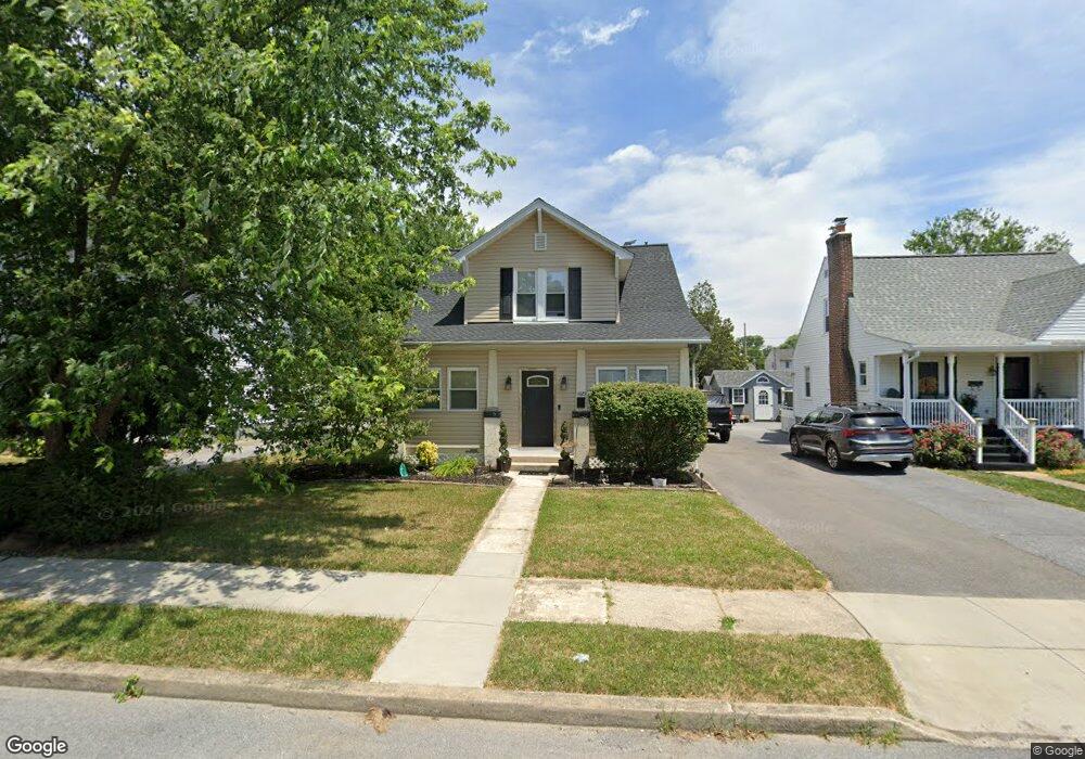
11023 Roessner Ave Hagerstown, MD 21740
Estimated Value: $224,000 - $283,000
--
Bed
1
Bath
1,044
Sq Ft
$245/Sq Ft
Est. Value
About This Home
This home is located at 11023 Roessner Ave, Hagerstown, MD 21740 and is currently estimated at $255,811, approximately $245 per square foot. 11023 Roessner Ave is a home located in Washington County with nearby schools including Lincolnshire Elementary School, Springfield Middle School, and Williamsport High School.
Ownership History
Date
Name
Owned For
Owner Type
Purchase Details
Closed on
May 19, 2004
Sold by
Shank Kari L
Bought by
Kevin Wolters
Current Estimated Value
Purchase Details
Closed on
Aug 9, 2001
Sold by
Walter Timothy S
Bought by
Shank Kari L and Langley Vernon B
Purchase Details
Closed on
Mar 27, 1992
Sold by
Brindle Theodore W
Bought by
Walter Timothy S
Home Financials for this Owner
Home Financials are based on the most recent Mortgage that was taken out on this home.
Original Mortgage
$71,250
Interest Rate
8.98%
Create a Home Valuation Report for This Property
The Home Valuation Report is an in-depth analysis detailing your home's value as well as a comparison with similar homes in the area
Home Values in the Area
Average Home Value in this Area
Purchase History
| Date | Buyer | Sale Price | Title Company |
|---|---|---|---|
| Kevin Wolters | $157,400 | -- | |
| Shank Kari L | $106,000 | -- | |
| Walter Timothy S | $75,000 | -- |
Source: Public Records
Mortgage History
| Date | Status | Borrower | Loan Amount |
|---|---|---|---|
| Previous Owner | Walter Timothy S | $71,250 | |
| Closed | Shank Kari L | -- |
Source: Public Records
Tax History Compared to Growth
Tax History
| Year | Tax Paid | Tax Assessment Tax Assessment Total Assessment is a certain percentage of the fair market value that is determined by local assessors to be the total taxable value of land and additions on the property. | Land | Improvement |
|---|---|---|---|---|
| 2025 | $1,835 | $214,500 | $55,700 | $158,800 |
| 2024 | $1,835 | $195,667 | $0 | $0 |
| 2023 | $1,739 | $176,833 | $0 | $0 |
| 2022 | $1,648 | $158,000 | $55,700 | $102,300 |
| 2021 | $1,577 | $153,100 | $0 | $0 |
| 2020 | $1,577 | $148,200 | $0 | $0 |
| 2019 | $1,534 | $143,300 | $55,700 | $87,600 |
| 2018 | $1,529 | $143,300 | $55,700 | $87,600 |
| 2017 | $1,533 | $143,300 | $0 | $0 |
| 2016 | -- | $148,800 | $0 | $0 |
| 2015 | $1,493 | $148,800 | $0 | $0 |
| 2014 | $1,493 | $148,800 | $0 | $0 |
Source: Public Records
Map
Nearby Homes
- 11029 Lincoln Ave
- 17410 Gay St
- 11033 Lincoln Ave
- 17400 Virginia Ave
- 17507 Gay St
- 17511 Gay St
- 17325 Gay St
- 11117 Nursery Rd
- 17325 Diane Dr
- 10903 Allen Ave
- 10901 Roessner Ave
- 17541 Virginia Ave
- 17623 Meadowood Dr
- 11015 Beckley Rd
- 10810 Rosewood Dr
- 17755 Halfway Blvd
- 11217 Hollywood Rd
- 17125 Miner Ave
- 17502 York Rd
- 10825 Wyncote Dr
- 11025 Roessner Ave
- 11021 Roessner Ave
- 11019 Roessner Ave
- 11027 Roessner Ave
- 11029 Roessner Ave
- 11017 Roessner Ave
- 11015 Roessner Ave
- 11024 Roessner Ave
- 11031 Roessner Ave
- 11022 Roessner Ave
- 11026 Roessner Ave
- 11020 Roessner Ave
- 11028 Roessner Ave
- 11018 Roessner Ave
- 11033 Roessner Ave
- 11013 Roessner Ave
- 11030 Roessner Ave
- 11016 Roessner Ave
- 11032 Roessner Ave
- 11014 Roessner Ave