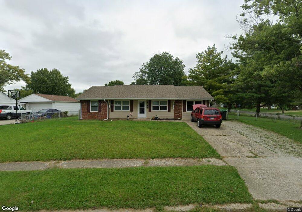
1103 Ashland Ave Whiteland, IN 46184
Estimated Value: $182,487 - $198,000
3
Beds
1
Bath
950
Sq Ft
$202/Sq Ft
Est. Value
About This Home
This home is located at 1103 Ashland Ave, Whiteland, IN 46184 and is currently estimated at $191,872, approximately $201 per square foot. 1103 Ashland Ave is a home located in Johnson County with nearby schools including Break-O-Day Elementary School, Clark-Pleasant Middle School, and Whiteland Community High School.
Ownership History
Date
Name
Owned For
Owner Type
Purchase Details
Closed on
Mar 25, 2025
Sold by
Mattick Stephen Douglas
Bought by
Stephen D Mattick Trust and Mattick
Current Estimated Value
Purchase Details
Closed on
Dec 14, 2012
Sold by
Mattick Properties Llc and Mattick Stephen D
Bought by
Mattick Stephen D and Mattick Gloria P
Purchase Details
Closed on
Aug 30, 2007
Sold by
Mattick Stephen D and Mattick Gloria P
Bought by
Mattick Properties I Llc
Create a Home Valuation Report for This Property
The Home Valuation Report is an in-depth analysis detailing your home's value as well as a comparison with similar homes in the area
Home Values in the Area
Average Home Value in this Area
Purchase History
| Date | Buyer | Sale Price | Title Company |
|---|---|---|---|
| Stephen D Mattick Trust | -- | None Listed On Document | |
| Mattick Stephen D | -- | None Available | |
| Mattick Properties I Llc | -- | None Available |
Source: Public Records
Tax History Compared to Growth
Tax History
| Year | Tax Paid | Tax Assessment Tax Assessment Total Assessment is a certain percentage of the fair market value that is determined by local assessors to be the total taxable value of land and additions on the property. | Land | Improvement |
|---|---|---|---|---|
| 2025 | $2,864 | $144,100 | $42,000 | $102,100 |
| 2024 | $2,864 | $137,100 | $42,000 | $95,100 |
| 2023 | $2,813 | $134,900 | $42,000 | $92,900 |
| 2022 | $2,730 | $131,400 | $35,000 | $96,400 |
| 2021 | $2,438 | $116,900 | $35,000 | $81,900 |
| 2020 | $1,814 | $86,400 | $24,100 | $62,300 |
| 2019 | $1,679 | $80,000 | $18,300 | $61,700 |
| 2018 | $1,644 | $78,300 | $15,500 | $62,800 |
| 2017 | $1,654 | $82,200 | $15,500 | $66,700 |
| 2016 | $1,448 | $74,700 | $15,500 | $59,200 |
| 2014 | $1,360 | $68,000 | $15,600 | $52,400 |
| 2013 | $1,360 | $69,800 | $15,700 | $54,100 |
Source: Public Records
Map
Nearby Homes
- 53 Oakden Ct
- 57 Oakden Ct
- 6540 N Us Highway 31
- 190 Tracy Ridge Blvd
- 256 Bittersweet Dr
- 106 Tracy Ridge Blvd
- 1119 Chateaugay Ct
- 638 Harvest Meadow Way
- 1041 Mount Olive Rd
- 559 Genisis Dr
- 840 Sweetbriar Ave
- 821 Princeton Dr
- 50 Meadow Creek Blvd
- 250 Southlane Dr
- 111 Meadow Creek Blvd
- 624 Sweetbriar Ave
- 0 E 700 N Unit MBR22036500
- 539 Delbrook Dr
- 12 Rypma Row
- 257 Creekway Ct
- 202 Brentwood Ln
- 1105 Ashland Ave
- 201 Brentwood Ln
- 142 Brentwood Ln
- 1108 Warwick Rd
- 204 Brentwood Ln
- 1107 Ashland Ave
- 1104 Ashland Ave
- 1110 Warwick Rd
- 203 Brentwood Ln
- 1106 Ashland Ave
- 1036 Ashland Ave
- 1035 Ashland Ave
- 1109 Ashland Ave
- 1112 Warwick Rd
- 1042 Warwick Rd
- 1034 Ashland Ave
- 1107 Warwick Rd
- 1033 Ashland Ave
- 1105 Warwick Rd