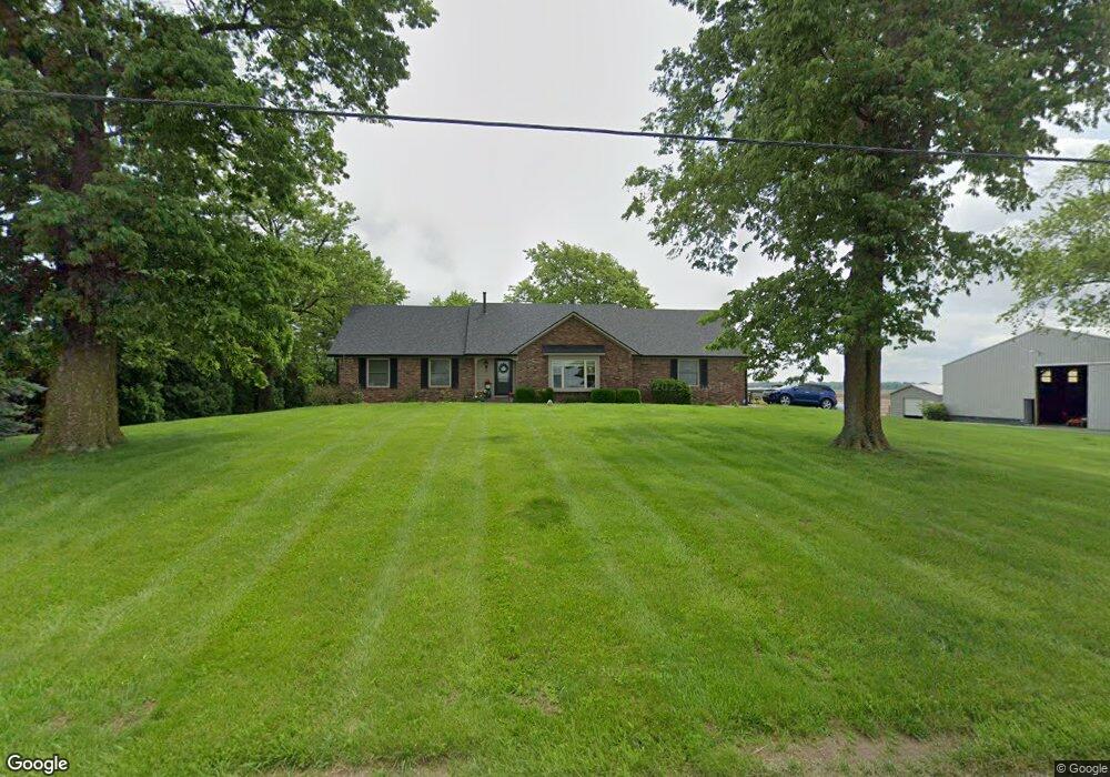
1103 S 600 E Franklin, IN 46131
Estimated Value: $388,722 - $442,000
3
Beds
3
Baths
1,990
Sq Ft
$204/Sq Ft
Est. Value
About This Home
This home is located at 1103 S 600 E, Franklin, IN 46131 and is currently estimated at $405,181, approximately $203 per square foot. 1103 S 600 E is a home located in Johnson County with nearby schools including Needham Elementary School, Franklin Community Middle School, and Custer Baker Intermediate School.
Ownership History
Date
Name
Owned For
Owner Type
Purchase Details
Closed on
Jul 13, 2007
Sold by
Roebuck Carolyn
Bought by
Slevin Ryan and Slevin Erin
Current Estimated Value
Home Financials for this Owner
Home Financials are based on the most recent Mortgage that was taken out on this home.
Original Mortgage
$144,000
Outstanding Balance
$91,220
Interest Rate
6.76%
Mortgage Type
New Conventional
Estimated Equity
$313,961
Purchase Details
Closed on
Oct 13, 2005
Sold by
Brown Ruth S
Bought by
Brown Farms Inc
Create a Home Valuation Report for This Property
The Home Valuation Report is an in-depth analysis detailing your home's value as well as a comparison with similar homes in the area
Home Values in the Area
Average Home Value in this Area
Purchase History
| Date | Buyer | Sale Price | Title Company |
|---|---|---|---|
| Slevin Ryan | -- | Mvp National Title | |
| Brown Farms Inc | -- | None Available |
Source: Public Records
Mortgage History
| Date | Status | Borrower | Loan Amount |
|---|---|---|---|
| Open | Slevin Ryan | $144,000 |
Source: Public Records
Tax History Compared to Growth
Tax History
| Year | Tax Paid | Tax Assessment Tax Assessment Total Assessment is a certain percentage of the fair market value that is determined by local assessors to be the total taxable value of land and additions on the property. | Land | Improvement |
|---|---|---|---|---|
| 2025 | $3,360 | $395,500 | $36,700 | $358,800 |
| 2024 | $3,360 | $331,000 | $36,700 | $294,300 |
| 2023 | $3,171 | $317,600 | $36,700 | $280,900 |
| 2022 | $3,577 | $317,600 | $36,700 | $280,900 |
| 2021 | $2,719 | $243,000 | $31,700 | $211,300 |
| 2020 | $2,317 | $208,300 | $27,700 | $180,600 |
| 2019 | $2,288 | $213,500 | $27,700 | $185,800 |
| 2018 | $1,989 | $200,900 | $27,700 | $173,200 |
| 2017 | $1,957 | $198,400 | $27,700 | $170,700 |
| 2016 | $1,875 | $182,900 | $27,700 | $155,200 |
| 2014 | $1,787 | $184,600 | $27,700 | $156,900 |
| 2013 | $1,787 | $184,600 | $27,700 | $156,900 |
Source: Public Records
Map
Nearby Homes
- 1980 S 550 E
- 150 E South St
- 863 S 450 E
- 1175 S Old Us Highway 31
- 2117 Jennifer Ct
- 2136 Jennifer Ct
- 2073 S Us Highway 31
- 1850 Longest Dr
- 2310 Fox Dr
- 7214 E 100 N
- 2580 Stonybrook Ln
- 1990 Red Oak Dr
- 1532 Williamsburg Ln
- 1083 Beechtree Ln
- 3151 E 150 S
- 1185 Beechtree Ln
- 1682 Millpond Ln
- 1669 Millpond Ln
- 1646 Millpond Ln
- 1636 Millpond Ln
- 550 S 510 E
- 0 S 600 E Unit 2928725
- 0 S 600 E Unit 21053746
- 0 S 600 E Unit 21182158
- 486 S 600 E
- 1104 S 550 E
- 1070 S 550 E
- 3517 E 550 S
- 5611 E 50 S
- 1423 S 550 E
- 5714 E 50 S
- 6534 E 50 S
- 5560 E Greensburg Rd
- 0 E Greensburg Rd Unit MBR21950969
- 0 E Greensburg Rd Unit MBR21850927
- 0 E Greensburg Rd Unit MBR9833259
- 6632 E 50 S
- 5495 E Greensburg Rd
- 247 S 600 E
- 5653 E Greensburg Rd