Estimated Value: $302,000 - $396,000
4
Beds
3
Baths
2,846
Sq Ft
$117/Sq Ft
Est. Value
About This Home
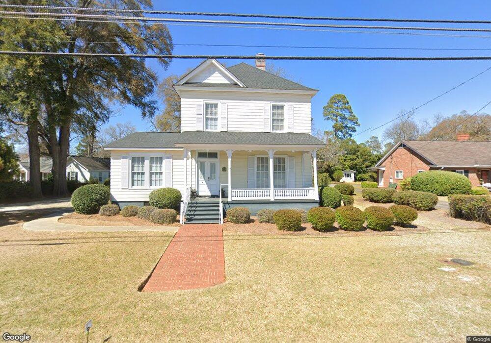
This home is located at 1103 Swift St, Perry, GA 31069 and is currently estimated at $333,663, approximately $117 per square foot. 1103 Swift St is a home located in Houston County with nearby schools including Morningside Elementary School, Perry Middle School, and Perry High School.
Ownership History
Date
Name
Owned For
Owner Type
Purchase Details
Closed on
May 24, 1989
Sold by
The Bank Of Perry
Bought by
Brewer Robert W and Brewer Sandra G
Current Estimated Value
Purchase Details
Closed on
Apr 13, 1987
Sold by
Mccants E Gardner
Bought by
The Bank Of Perry
Purchase Details
Closed on
Mar 26, 1987
Sold by
Chapman Emmie B
Bought by
Chapman H E
Purchase Details
Closed on
Sep 15, 1962
Bought by
Hawk David W
Purchase Details
Closed on
Apr 6, 1948
Bought by
Chapman C C
Create a Home Valuation Report for This Property
The Home Valuation Report is an in-depth analysis detailing your home's value as well as a comparison with similar homes in the area
Home Values in the Area
Average Home Value in this Area
Purchase History
| Date | Buyer | Sale Price | Title Company |
|---|---|---|---|
| Brewer Robert W | $81,400 | -- | |
| The Bank Of Perry | -- | -- | |
| Chapman H E | -- | -- | |
| Hawk David W | -- | -- | |
| Chapman C C | -- | -- |
Source: Public Records
Tax History Compared to Growth
Tax History
| Year | Tax Paid | Tax Assessment Tax Assessment Total Assessment is a certain percentage of the fair market value that is determined by local assessors to be the total taxable value of land and additions on the property. | Land | Improvement |
|---|---|---|---|---|
| 2024 | $2,787 | $77,100 | $6,080 | $71,020 |
| 2023 | $2,449 | $67,456 | $6,080 | $61,376 |
| 2022 | $1,365 | $61,376 | $6,080 | $55,296 |
| 2021 | $1,270 | $56,920 | $6,080 | $50,840 |
| 2020 | $1,150 | $51,520 | $6,080 | $45,440 |
| 2019 | $1,150 | $51,520 | $6,080 | $45,440 |
| 2018 | $1,150 | $51,520 | $6,080 | $45,440 |
| 2017 | $1,152 | $51,520 | $6,080 | $45,440 |
| 2016 | $1,153 | $51,520 | $6,080 | $45,440 |
| 2015 | $1,156 | $51,520 | $6,080 | $45,440 |
| 2014 | -- | $51,520 | $6,080 | $45,440 |
| 2013 | -- | $51,520 | $6,080 | $45,440 |
Source: Public Records
Map
Nearby Homes
- 1207 Swift St
- 1212 Swift St
- 0 Carroll Aly
- 113 Pridgen Pass
- 104 Pridgen Pass
- 126 Bramblewood Ln
- 905 Massee Ln
- 903 Massee Ln
- 104 Gunner Ln
- 1343 Wf Ragin Dr
- 1312 Sam Nunn Blvd
- 1335 Ball St
- The Pearson Plan at Avalon
- The Crawford Plan at Avalon
- The Piedmont Plan at Avalon
- The McGinnis Plan at Avalon
- The Coleman Plan at Avalon
- The Lawson Plan at Avalon
- The Bradley Plan at Avalon
- The Harrington Plan at Avalon
- 1101 Swift St
- 1105 Swift St
- LOT 204 Rambo Way
- LOT 202 Rambo Way
- 1107 Swift St
- 1103 S 2nd St Unit 4
- 1103 S 2nd St
- 1103 2nd St
- LOT 60 Bankstone Landing
- LOT 65 Bankstone Landing
- LOT 55 Bankstone Landing
- 1107 S 2nd St Unit 2
- 1107 2nd St Unit . 2
- 1107 2nd St Unit . 1
- LOT 87 Sadie Heights
- LOT 83 Sadie Heights
- LOT 91 Sadie Heights
- LOT 91 Sadie Heights Unit 91
- 1006 1st St
- 1201 Swift St