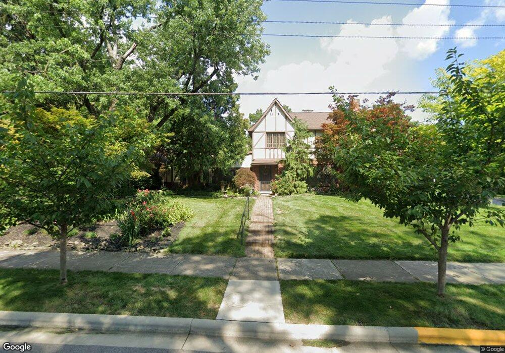
1104 Westwood Ave Columbus, OH 43212
Estimated Value: $936,000 - $1,119,948
5
Beds
4
Baths
3,143
Sq Ft
$326/Sq Ft
Est. Value
About This Home
This home is located at 1104 Westwood Ave, Columbus, OH 43212 and is currently estimated at $1,023,237, approximately $325 per square foot. 1104 Westwood Ave is a home located in Franklin County with nearby schools including Robert Louis Stevenson Elementary School, Larson Middle School, and Grandview Heights High School.
Ownership History
Date
Name
Owned For
Owner Type
Purchase Details
Closed on
Aug 5, 2002
Sold by
Estate Of Charles James
Bought by
James Ruthanne
Current Estimated Value
Purchase Details
Closed on
Aug 7, 1985
Bought by
James Charles
Purchase Details
Closed on
Dec 1, 1983
Create a Home Valuation Report for This Property
The Home Valuation Report is an in-depth analysis detailing your home's value as well as a comparison with similar homes in the area
Home Values in the Area
Average Home Value in this Area
Purchase History
| Date | Buyer | Sale Price | Title Company |
|---|---|---|---|
| James Ruthanne | -- | -- | |
| James Charles | $134,000 | -- | |
| -- | $134,900 | -- |
Source: Public Records
Tax History Compared to Growth
Tax History
| Year | Tax Paid | Tax Assessment Tax Assessment Total Assessment is a certain percentage of the fair market value that is determined by local assessors to be the total taxable value of land and additions on the property. | Land | Improvement |
|---|---|---|---|---|
| 2024 | $16,494 | $282,800 | $122,220 | $160,580 |
| 2023 | $14,449 | $282,800 | $122,220 | $160,580 |
| 2022 | $17,088 | $284,800 | $136,360 | $148,440 |
| 2021 | $15,998 | $284,800 | $136,360 | $148,440 |
| 2020 | $15,932 | $284,800 | $136,360 | $148,440 |
| 2019 | $16,227 | $256,730 | $136,360 | $120,370 |
| 2018 | $14,618 | $256,730 | $136,360 | $120,370 |
| 2017 | $14,104 | $256,730 | $136,360 | $120,370 |
| 2016 | $13,078 | $189,980 | $85,120 | $104,860 |
| 2015 | $13,079 | $189,980 | $85,120 | $104,860 |
| 2014 | $13,119 | $189,980 | $85,120 | $104,860 |
| 2013 | $5,764 | $172,725 | $77,385 | $95,340 |
Source: Public Records
Map
Nearby Homes
- 1000 Urlin Ave Unit 1822
- 1000 Urlin Ave Unit 2007
- 1000 Urlin Ave Unit 520
- 1000 Urlin Ave Unit 605
- 1000 Urlin Ave Unit 511
- 1000 Urlin Ave Unit 1007
- 1000 Urlin Ave Unit 518
- 1000 Urlin Ave Unit 1607
- 1313 Lincoln Rd
- 1459 Elmwood Ave Unit 1459
- 1475 W 3rd Ave Unit 204
- 1359 Bluff Ave Unit A
- 1561 Glenn Ave
- 1301 Lake Shore Dr Unit 199
- 2015 W 5th Ave Unit 211
- 2015 W 5th Ave Unit 102
- 2015 W 5th Ave Unit 108
- 1661 Ashland Ave Unit 663
- 1631 Roxbury Rd Unit F3
- 1631 Roxbury Rd Unit B6
- 1800 Bluff Ave
- 1122 Westwood Ave
- 1794 Bluff Ave
- 1784 Bluff Ave
- 1130 Westwood Ave
- 1105 Westwood Ave
- 1113 Westwood Ave
- 1085 Westwood Ave
- 1087 Elmwood Ave
- 1125 Westwood Ave
- 1115 Elmwood Ave
- 1793 Bluff Ave
- 1138 Westwood Ave
- 10 Stonegate Village Dr
- 1852 Bluff Ave
- 1787 Bluff Ave
- 1131 Westwood Ave
- 1125 Elmwood Ave
- 1068 Westwood Ave
- 1845 Bluff Ave