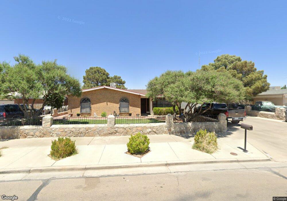
11047 Sam Snead Dr El Paso, TX 79936
Glen Cove NeighborhoodEstimated Value: $225,801 - $245,000
3
Beds
2
Baths
1,513
Sq Ft
$156/Sq Ft
Est. Value
About This Home
This home is located at 11047 Sam Snead Dr, El Paso, TX 79936 and is currently estimated at $236,700, approximately $156 per square foot. 11047 Sam Snead Dr is a home located in El Paso County with nearby schools including Glen Cove Elementary School, J.M. Hanks Middle School, and J M Hanks High School.
Ownership History
Date
Name
Owned For
Owner Type
Purchase Details
Closed on
Jul 20, 1998
Sold by
Horton Donald H and Horton Myrtle A
Bought by
Venegas Jose M and Dominguez Venegas Raquel
Current Estimated Value
Home Financials for this Owner
Home Financials are based on the most recent Mortgage that was taken out on this home.
Original Mortgage
$75,050
Outstanding Balance
$15,279
Interest Rate
6.94%
Estimated Equity
$221,422
Create a Home Valuation Report for This Property
The Home Valuation Report is an in-depth analysis detailing your home's value as well as a comparison with similar homes in the area
Home Values in the Area
Average Home Value in this Area
Purchase History
| Date | Buyer | Sale Price | Title Company |
|---|---|---|---|
| Venegas Jose M | -- | -- |
Source: Public Records
Mortgage History
| Date | Status | Borrower | Loan Amount |
|---|---|---|---|
| Open | Venegas Jose M | $75,050 |
Source: Public Records
Tax History Compared to Growth
Tax History
| Year | Tax Paid | Tax Assessment Tax Assessment Total Assessment is a certain percentage of the fair market value that is determined by local assessors to be the total taxable value of land and additions on the property. | Land | Improvement |
|---|---|---|---|---|
| 2025 | $3,379 | $207,093 | -- | -- |
| 2024 | $3,379 | $188,266 | -- | -- |
| 2023 | $3,138 | $171,151 | $0 | $0 |
| 2022 | $4,832 | $155,592 | $0 | $0 |
| 2021 | $4,598 | $146,520 | $26,691 | $119,829 |
| 2020 | $4,061 | $128,588 | $19,803 | $108,785 |
| 2018 | $3,968 | $127,587 | $19,803 | $107,784 |
| 2017 | $3,570 | $116,806 | $19,803 | $97,003 |
| 2016 | $3,570 | $116,806 | $19,803 | $97,003 |
| 2015 | $2,770 | $116,806 | $19,803 | $97,003 |
| 2014 | $2,770 | $117,074 | $19,803 | $97,271 |
Source: Public Records
Map
Nearby Homes
- 2308 Tom Watson Ct
- 11008 Johnny Miller Dr
- 2604 Anise Dr
- 2348 Sea Side Dr
- 11013 Bob Stone Dr
- 11016 Bob Stone Dr
- 11012 Bob Stone Dr
- 11132 Wharf Cove Dr
- 2825 Wong Place Unit A/D
- 2009 Bobby Jones Dr Unit B
- 2820 Beachcomber Dr
- 2325 Ken Venturi Ln
- 2001 Bobby Jones Dr Unit A
- 1913 Seagull Dr
- 11201 Skipper Dr
- 10916 Miller Barber Dr
- 1868 Tom Bolt Dr
- 11129 Nautical Dr
- 1901 Bobby Jones Dr
- 11276 Skipper Dr
- 11051 Sam Snead Dr
- 11043 Sam Snead Dr
- 2304 Jim Dent Ct
- 2305 Tom Watson Ct
- 11055 Sam Snead Dr
- 11048 Sam Snead Dr
- 11044 Sam Snead Dr
- 2308 Jim Dent Ct
- 11052 Sam Snead Dr
- 11040 Sam Snead Dr
- 11040 Sam Snead Dr
- 11035 Sam Snead Dr
- 2305 Jim Dent Ct
- 2309 Tom Watson Ct
- 11036 Sam Snead Dr
- 2312 Jim Dent Ct
- 11056 Sam Snead Dr
- 2313 Jim Dent Ct
- 11047 Johnny Miller Dr
- 11043 Johnny Miller Dr