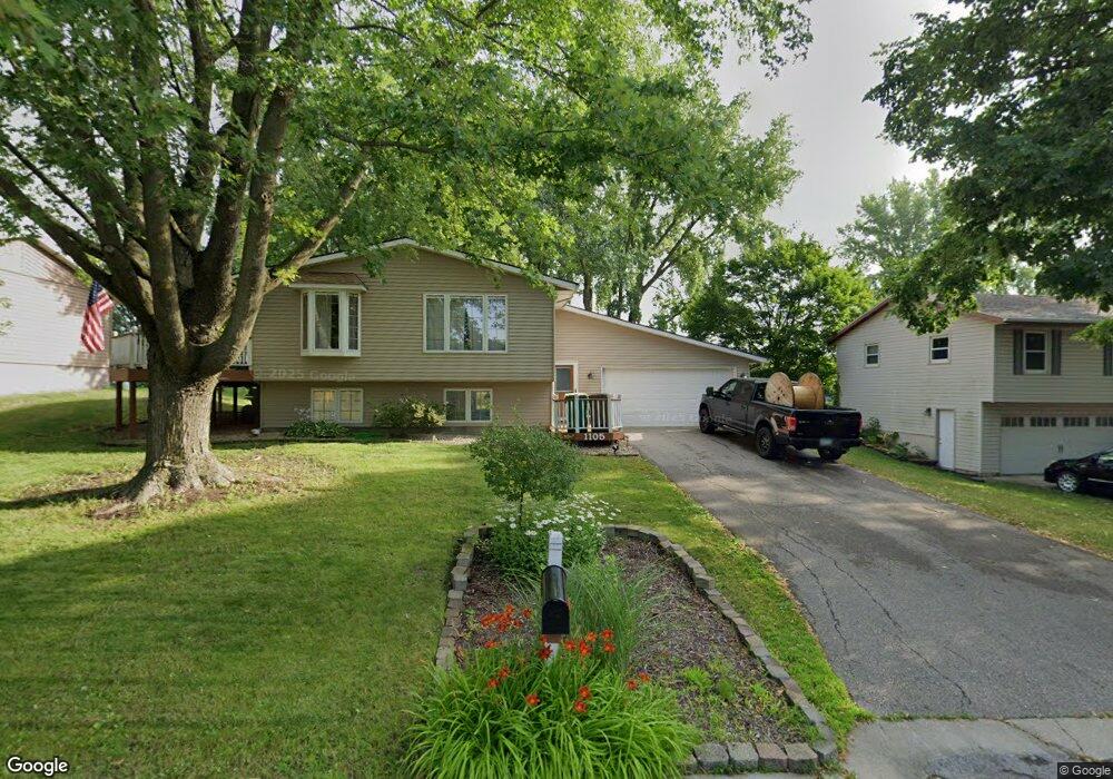
1105 Eastgate Rd Albert Lea, MN 56007
Estimated Value: $201,000 - $217,000
2
Beds
2
Baths
1,525
Sq Ft
$136/Sq Ft
Est. Value
About This Home
This home is located at 1105 Eastgate Rd, Albert Lea, MN 56007 and is currently estimated at $207,057, approximately $135 per square foot. 1105 Eastgate Rd is a home located in Freeborn County with nearby schools including Hawthorne Elementary School, Southwest Middle School, and Albert Lea Senior High School.
Ownership History
Date
Name
Owned For
Owner Type
Purchase Details
Closed on
Dec 2, 2021
Sold by
Tovar Linda D and Tovar Revocable Trust
Bought by
Ruddle Eric
Current Estimated Value
Home Financials for this Owner
Home Financials are based on the most recent Mortgage that was taken out on this home.
Original Mortgage
$161,505
Outstanding Balance
$148,502
Interest Rate
3.09%
Mortgage Type
New Conventional
Estimated Equity
$58,555
Create a Home Valuation Report for This Property
The Home Valuation Report is an in-depth analysis detailing your home's value as well as a comparison with similar homes in the area
Home Values in the Area
Average Home Value in this Area
Purchase History
| Date | Buyer | Sale Price | Title Company |
|---|---|---|---|
| Ruddle Eric | $166,500 | None Available |
Source: Public Records
Mortgage History
| Date | Status | Borrower | Loan Amount |
|---|---|---|---|
| Open | Ruddle Eric | $161,505 |
Source: Public Records
Tax History
| Year | Tax Paid | Tax Assessment Tax Assessment Total Assessment is a certain percentage of the fair market value that is determined by local assessors to be the total taxable value of land and additions on the property. | Land | Improvement |
|---|---|---|---|---|
| 2025 | $2,348 | $193,700 | $20,600 | $173,100 |
| 2024 | $2,110 | $174,900 | $20,600 | $154,300 |
| 2023 | $2,116 | $156,500 | $20,600 | $135,900 |
| 2022 | $2,008 | $157,300 | $20,600 | $136,700 |
| 2021 | $2,268 | $133,200 | $20,600 | $112,600 |
| 2020 | $2,336 | $138,400 | $19,000 | $119,400 |
| 2019 | $1,982 | $120,600 | $16,800 | $103,800 |
| 2018 | $1,712 | $0 | $0 | $0 |
| 2016 | $944 | $0 | $0 | $0 |
| 2015 | $866 | $0 | $0 | $0 |
| 2014 | $1,084 | $0 | $0 | $0 |
| 2012 | $1,568 | $0 | $0 | $0 |
Source: Public Records
Map
Nearby Homes
- 1117 Eastgate Rd
- 1617 Crystal Dr
- 1626 Keystone Dr
- 1106 Foothills Cir
- 705 Glenview Dr
- 1609 Keystone Dr
- 1306 Crestview Rd
- 2021 Bridge Ave
- 307 E Richway Dr
- 1306 Marie Ave
- 1103 Amelia Ave
- 415 E Hawthorne St
- 808 Freeborn Ave
- 1808 Lakewood Ave
- 103 W Richway Dr
- 209 Burr Oak Dr
- 2141 Harmony Ave
- 802 Valley Ave
- 1405 Johnson St
- 620 Saint Thomas Ave
- 1109 Eastgate Rd
- 1101 Eastgate Rd
- 1706 Portland Ave
- 1108 Allan Dr
- 1113 Eastgate Rd
- 1620 1620 Portland Ave
- 1620 Portland Ave
- 1618 Portland Ave
- 1013 Eastgate Rd
- 1112 Allan Dr
- 1614 Portland Ave
- 1014 Allan Dr
- 1009 Eastgate Rd
- 1621 Portland Ave
- 1121 Eastgate Rd
- 1109 Allan Dr
- 1105 Allan Dr
- 1610 Portland Ave
- 1711 Garfield Ave
- 1008 Allan Dr
Your Personal Tour Guide
Ask me questions while you tour the home.