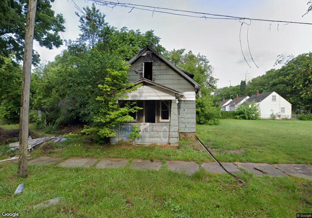
1105 N Vernon Ave Flint, MI 48506
Eastside NeighborhoodEstimated Value: $34,000 - $39,000
3
Beds
1
Bath
920
Sq Ft
$40/Sq Ft
Est. Value
About This Home
This home is located at 1105 N Vernon Ave, Flint, MI 48506 and is currently estimated at $36,500, approximately $39 per square foot. 1105 N Vernon Ave is a home located in Genesee County with nearby schools including Potter School, Flint Cultural Center Academy, and WAY Academy of Flint.
Ownership History
Date
Name
Owned For
Owner Type
Purchase Details
Closed on
Dec 20, 2017
Sold by
Cherry Deborah L and The Genesee County Treasurer
Bought by
Genesee County Land Bank Authority
Current Estimated Value
Purchase Details
Closed on
Oct 29, 2008
Sold by
Assaf Manal
Bought by
Rondiceson Llc
Purchase Details
Closed on
Oct 20, 2008
Sold by
Preston Steven C and Secretary Of Housing & Urban D
Bought by
Assaf Manal
Purchase Details
Closed on
Sep 28, 2007
Sold by
Standard Federal Bank
Bought by
Hud
Purchase Details
Closed on
Mar 28, 2007
Sold by
Shipley Larry C and Shipley Margaret L
Bought by
Standard Federal Bank and Central State Sla
Create a Home Valuation Report for This Property
The Home Valuation Report is an in-depth analysis detailing your home's value as well as a comparison with similar homes in the area
Home Values in the Area
Average Home Value in this Area
Purchase History
| Date | Buyer | Sale Price | Title Company |
|---|---|---|---|
| Genesee County Land Bank Authority | -- | None Available | |
| Rondiceson Llc | -- | None Available | |
| Assaf Manal | $1,000 | None Available | |
| Hud | -- | None Available | |
| Standard Federal Bank | $16,652 | None Available |
Source: Public Records
Tax History Compared to Growth
Tax History
| Year | Tax Paid | Tax Assessment Tax Assessment Total Assessment is a certain percentage of the fair market value that is determined by local assessors to be the total taxable value of land and additions on the property. | Land | Improvement |
|---|---|---|---|---|
| 2025 | -- | $0 | $0 | $0 |
| 2024 | -- | $0 | $0 | $0 |
| 2023 | -- | $0 | $0 | $0 |
| 2022 | $0 | $0 | $0 | $0 |
| 2021 | $0 | $0 | $0 | $0 |
| 2020 | $0 | $0 | $0 | $0 |
| 2019 | $642 | $0 | $0 | $0 |
| 2018 | $221 | $0 | $0 | $0 |
| 2017 | $646 | $0 | $0 | $0 |
| 2016 | $642 | $0 | $0 | $0 |
| 2015 | -- | $0 | $0 | $0 |
| 2014 | -- | $0 | $0 | $0 |
| 2012 | -- | $8,300 | $0 | $0 |
Source: Public Records
Map
Nearby Homes
- 2301 Missouri Ave
- 1501 Arlington Ave
- 1318 Cronk Ave
- 2605 Nebraska Ave
- 1622 Arlington Ave
- 2610 Pennsylvania Ave
- 1216 Minnesota Ave
- 406 S Lynch St
- 2601 Illinois Ave
- 1609 Ohio Ave
- 524 S Lynch St
- 605 S Lynch St
- 2131 Windemere Ave
- 602 S Meade St
- 1805 Bennett Ave
- 2211 Torrance St
- 1814 Mabel Ave
- 2013 E Court St
- 2321 Levern St
- 1529 Broadway Blvd
- 2125 Nebraska Ave
- 2129 Nebraska Ave
- 1117 N Vernon Ave
- 2132 Kentucky Ave
- 2121 Nebraska Ave
- 2201 Nebraska Ave
- 2124 Kentucky Ave
- 2202 Kentucky Ave
- 2117 Nebraska Ave
- 2120 Kentucky Ave
- 2205 Nebraska Ave
- 2113 Nebraska Ave
- 2126 Nebraska Ave
- 2209 Nebraska Ave
- 2109 Nebraska Ave
- 2210 Kentucky Ave
- 2202 Nebraska Ave
- 2116 Nebraska Ave
- 2131 Kentucky Ave
- 2127 Kentucky Ave