Estimated Value: $284,000 - $310,000
3
Beds
2
Baths
1,610
Sq Ft
$184/Sq Ft
Est. Value
About This Home
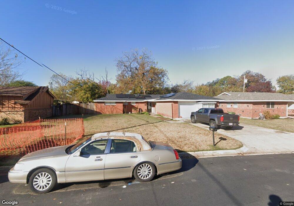
This home is located at 1105 Norwood Dr, Hurst, TX 76053 and is currently estimated at $296,339, approximately $184 per square foot. 1105 Norwood Dr is a home located in Tarrant County with nearby schools including Harrison Lane Elementary School, Hurst J High School, and L.D. Bell High School.
Ownership History
Date
Name
Owned For
Owner Type
Purchase Details
Closed on
Apr 13, 2005
Sold by
Finch Edward N and Finch Mava Ann
Bought by
The Nathan & Mava Finch Living Trust
Current Estimated Value
Purchase Details
Closed on
Oct 15, 1993
Sold by
Construction Relations Inc
Bought by
Finch Edward N and Finch Mava A
Home Financials for this Owner
Home Financials are based on the most recent Mortgage that was taken out on this home.
Original Mortgage
$69,164
Interest Rate
6.87%
Mortgage Type
FHA
Create a Home Valuation Report for This Property
The Home Valuation Report is an in-depth analysis detailing your home's value as well as a comparison with similar homes in the area
Home Values in the Area
Average Home Value in this Area
Purchase History
| Date | Buyer | Sale Price | Title Company |
|---|---|---|---|
| The Nathan & Mava Finch Living Trust | -- | -- | |
| Finch Edward N | -- | Lawyers American Title |
Source: Public Records
Mortgage History
| Date | Status | Borrower | Loan Amount |
|---|---|---|---|
| Previous Owner | Finch Edward N | $69,164 |
Source: Public Records
Tax History Compared to Growth
Tax History
| Year | Tax Paid | Tax Assessment Tax Assessment Total Assessment is a certain percentage of the fair market value that is determined by local assessors to be the total taxable value of land and additions on the property. | Land | Improvement |
|---|---|---|---|---|
| 2025 | $3,332 | $277,951 | $55,000 | $222,951 |
| 2024 | $3,332 | $277,951 | $55,000 | $222,951 |
| 2023 | $5,308 | $264,942 | $40,000 | $224,942 |
| 2022 | $5,366 | $233,076 | $40,000 | $193,076 |
| 2021 | $5,377 | $222,946 | $40,000 | $182,946 |
| 2020 | $4,247 | $176,543 | $40,000 | $136,543 |
| 2019 | $4,132 | $168,814 | $40,000 | $128,814 |
| 2018 | $3,883 | $158,646 | $19,000 | $139,646 |
| 2017 | $3,660 | $144,616 | $19,000 | $125,616 |
| 2016 | $3,163 | $125,000 | $19,000 | $106,000 |
| 2015 | $2,072 | $79,000 | $15,000 | $64,000 |
| 2014 | $2,072 | $79,000 | $15,000 | $64,000 |
Source: Public Records
Map
Nearby Homes
- 1136 Simpson Dr
- 1016 Keith Dr
- 905 Brown Trail
- 1220 Norwood Dr
- 802 Brown Trail
- 803 Glenda Dr
- 127 W Cedar St
- 409 Vicki Place
- 420 Bedford Ct W
- 341 Hurst Dr
- 400 Joanna Dr
- 344 Bedford Ct E
- 624 Harrison Ln
- 116 Oakhurst Dr
- 644 Caduceus Ln
- 849 Russell Ln
- 1337 Harrison Ln
- 1208 Karla Dr
- 1348 Norwood Dr
- 1008 Russell Ln
- 1109 Norwood Dr
- 1101 Norwood Dr
- 1104 Simpson Dr
- 1108 Simpson Dr
- 1113 Norwood Dr
- 1100 Simpson Dr
- 1104 Norwood Dr
- 1112 Simpson Dr
- 1100 Norwood Dr
- 1108 Norwood Dr
- 1117 Norwood Dr
- 101 W Cheryl Ave
- 105 W Cheryl Ave
- 1112 Norwood Dr
- 1116 Simpson Dr
- 100 E Cheryl Ave
- 1105 Simpson Dr
- 1121 Norwood Dr
- 1109 Simpson Dr
- 1105 Valley View Dr