

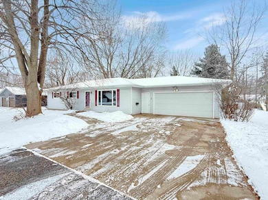
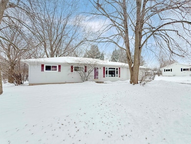
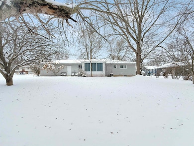


1105 Onstad Dr Marshfield, WI 54449
Estimated payment $1,649/month
Total Views
7,365
3
Beds
2
Baths
2,474
Sq Ft
$101
Price per Sq Ft
Highlights
- Hot Property
- Ranch Style House
- Porch
- Marshfield High School Rated A
- Lower Floor Utility Room
- 2 Car Attached Garage
About This Home
WEST SIDE RANCH HOME! Welcome to this inviting 3-bedroom, 2-bath ranch home located on Marshfield’s desirable West Side. A large picture window fills the living room with natural light, creating a warm and welcoming space. With a flowing layout, you’ll find yourself in the nice sized dining space that provides ample room for entertaining guests. With an adjacently located kitchen, you’ll be able to mingle while prepping your meals. An abundant amount of charming cabinetry coupled with a practical layout - the kitchen provides the perfect mix of functionality for your everyday cooking. Enjoy summer lounging or find relaxation in the morning sipping coffee in the bright and cozy 3-seasons room overlooking your backyard. The main level includes a full-size bathroom, two comfortable bedrooms, and a primary bedroom complete with its own private bath. The lower level expands your living options with a spacious family room featuring built-ins for convenient storage, along with two versatile bonus rooms ideal for hobbies, a home office, or additional flex space. Outside, you’ll appreciate the low-maintenance vinyl siding, an attached 2-car garage, and a nicely sized lot offering room to relax or play. This home delivers space, comfort, and a great location—ready to welcome its next owner!
Home Details
Home Type
- Single Family
Est. Annual Taxes
- $4,019
Year Built
- Built in 1973
Lot Details
- 0.29 Acre Lot
- Lot Dimensions are 100x130
Home Design
- Ranch Style House
- Poured Concrete
- Shingle Roof
- Vinyl Siding
Interior Spaces
- Ceiling Fan
- Window Treatments
- Lower Floor Utility Room
Kitchen
- Electric Oven or Range
- Microwave
- Dishwasher
Flooring
- Carpet
- Laminate
- Vinyl
Bedrooms and Bathrooms
- 3 Bedrooms
- 2 Full Bathrooms
Laundry
- Laundry on lower level
- Dryer
- Washer
Partially Finished Basement
- Basement Fills Entire Space Under The House
- Sump Pump
Parking
- 2 Car Attached Garage
- Garage Door Opener
- Driveway
Outdoor Features
- Porch
Utilities
- Forced Air Heating and Cooling System
- Natural Gas Water Heater
- Public Septic
Listing and Financial Details
- Assessor Parcel Number 3305141
Matterport 3D Tour
Map
Create a Home Valuation Report for This Property
The Home Valuation Report is an in-depth analysis detailing your home's value as well as a comparison with similar homes in the area
Home Values in the Area
Average Home Value in this Area
Tax History
| Year | Tax Paid | Tax Assessment Tax Assessment Total Assessment is a certain percentage of the fair market value that is determined by local assessors to be the total taxable value of land and additions on the property. | Land | Improvement |
|---|---|---|---|---|
| 2024 | $3,768 | $212,200 | $33,900 | $178,300 |
| 2023 | $3,321 | $212,200 | $33,900 | $178,300 |
| 2022 | $3,751 | $148,000 | $25,400 | $122,600 |
| 2021 | $3,501 | $148,000 | $25,400 | $122,600 |
| 2020 | $3,493 | $148,000 | $25,400 | $122,600 |
| 2019 | $3,339 | $148,000 | $25,400 | $122,600 |
| 2018 | $3,235 | $148,000 | $25,400 | $122,600 |
| 2017 | $3,247 | $148,000 | $25,400 | $122,600 |
| 2016 | $3,223 | $148,000 | $25,400 | $122,600 |
| 2015 | $3,221 | $148,000 | $25,400 | $122,600 |
Source: Public Records
Property History
| Date | Event | Price | List to Sale | Price per Sq Ft |
|---|---|---|---|---|
| 12/03/2025 12/03/25 | For Sale | $249,900 | -- | $101 / Sq Ft |
Source: Central Wisconsin Multiple Listing Service
Purchase History
| Date | Type | Sale Price | Title Company |
|---|---|---|---|
| Warranty Deed | $328,000 | None Available | |
| Warranty Deed | $164,000 | -- | |
| Warranty Deed | $154,900 | Badger Title Llc | |
| Warranty Deed | $154,900 | -- |
Source: Public Records
Mortgage History
| Date | Status | Loan Amount | Loan Type |
|---|---|---|---|
| Open | $151,607 | FHA | |
| Closed | $151,607 | FHA | |
| Previous Owner | $110,000 | New Conventional |
Source: Public Records
About the Listing Agent
Hi! We're Sue & Sammy - a full-service, fully licensed, Real Estate marketing team whose main focus is on our clients and customer service. We love to work with sellers and buyers helping to navigate transactions and processes. With over 30 years In the Industry, we bring a unique combination of loads of experience + a team member with a background In marketing and design.
What makes us different than your ordinary agent? 1: We are a Real Estate TEAM! That means more coverage and
Brock & Decker's Other Listings
Source: Central Wisconsin Multiple Listing Service
MLS Number: 22505618
APN: 3305141
Disclaimer: Certain information contained herein is derived from information provided by parties other than Homes.com. All information provided is deemed reliable, but is not guaranteed to be accurate and should be independently verified.
![]() IDX information is provided exclusively for personal, non-commercial use, and may not be used for any purpose other than to identify prospective properties consumers may be interested in purchasing. Information is deemed reliable but not guaranteed.
IDX information is provided exclusively for personal, non-commercial use, and may not be used for any purpose other than to identify prospective properties consumers may be interested in purchasing. Information is deemed reliable but not guaranteed.
Nearby Homes
- 1200 W State St
- 900 Sawyer Dr
- 1006 N Columbus Ave
- 1709 W Andrea St
- Lot 31 Daniels Addition
- 404 S Birch Ave
- 406 S Birch Ave
- 1311 N Wood Ave
- 404 S Cypress Ave
- 504 W 4th St
- 718 S Drake Ave
- 1601 Immanuel Ct
- 2112 W 3rd St
- 9850 County Road Y
- 310 W 4th St
- 200 N Walnut Ave
- 508 W 8th St
- 1511 N Broadway Ave
- 907 S Oak Ave
- Lot #1 Meadow Ave
- 103 W 2nd St
- 112 E 2nd St
- 1626 N Fig Ave
- 1511 S Locust Ave
- 1506 S Adams Ave
- 701 W 17th St
- 801-895 W 17th St
- 301 W 17th St
- 1624 S Roddis Ave
- 810 E Harrison St
- 1518 N Peach Ave
- 905 E Grant St
- 1407 N Peach Ave
- 504 E 21st St
- 2400 N Peach Ave
- 1808 N Hume Ave
- 1007 N Hume Ave
- 912 N Irene Ave
- 2404 E Forest St
- 100 E Clark St