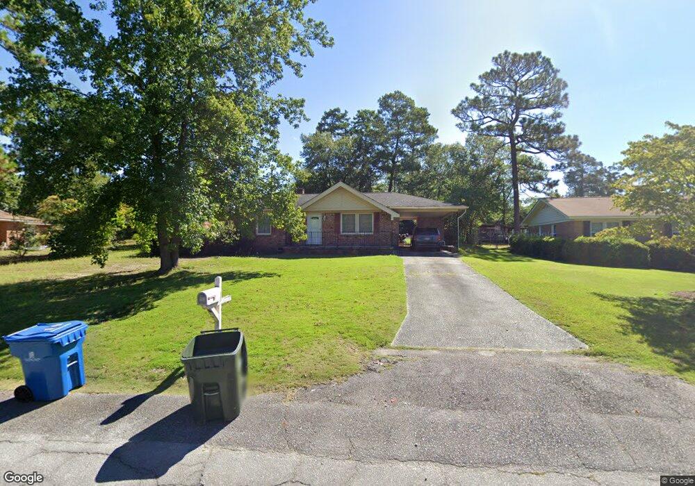
1105 Price Cir West Columbia, SC 29169
Estimated Value: $172,668 - $201,000
3
Beds
2
Baths
1,422
Sq Ft
$129/Sq Ft
Est. Value
About This Home
This home is located at 1105 Price Cir, West Columbia, SC 29169 and is currently estimated at $182,917, approximately $128 per square foot. 1105 Price Cir is a home located in Lexington County with nearby schools including Cayce Elementary, Cyril B. Busbee Creative Arts Academy, and Brookland-Cayce High School.
Ownership History
Date
Name
Owned For
Owner Type
Purchase Details
Closed on
Feb 21, 2017
Sold by
Federal National Mortgage Association
Bought by
Horne Terri Rebekah
Current Estimated Value
Home Financials for this Owner
Home Financials are based on the most recent Mortgage that was taken out on this home.
Original Mortgage
$5,000
Outstanding Balance
$934
Interest Rate
4.1%
Mortgage Type
Unknown
Estimated Equity
$181,983
Purchase Details
Closed on
Dec 14, 2012
Sold by
Connelly Michael R
Bought by
Federal National Mortgage Association
Purchase Details
Closed on
May 17, 2004
Sold by
Hawsey Kelly O
Bought by
Overstreet Charles D
Purchase Details
Closed on
May 14, 2004
Sold by
Fowler Al J
Bought by
Connelly Mike R
Create a Home Valuation Report for This Property
The Home Valuation Report is an in-depth analysis detailing your home's value as well as a comparison with similar homes in the area
Home Values in the Area
Average Home Value in this Area
Purchase History
| Date | Buyer | Sale Price | Title Company |
|---|---|---|---|
| Horne Terri Rebekah | $84,900 | None Available | |
| Federal National Mortgage Association | $93,538 | -- | |
| Overstreet Charles D | $119,000 | -- | |
| Connelly Mike R | $96,820 | -- |
Source: Public Records
Mortgage History
| Date | Status | Borrower | Loan Amount |
|---|---|---|---|
| Open | Horne Terri Rebekah | $5,000 | |
| Previous Owner | Horne Terri Rebekah | $83,361 |
Source: Public Records
Tax History Compared to Growth
Tax History
| Year | Tax Paid | Tax Assessment Tax Assessment Total Assessment is a certain percentage of the fair market value that is determined by local assessors to be the total taxable value of land and additions on the property. | Land | Improvement |
|---|---|---|---|---|
| 2024 | $719 | $3,392 | $720 | $2,672 |
| 2023 | $648 | $3,392 | $720 | $2,672 |
| 2022 | $654 | $3,392 | $720 | $2,672 |
| 2020 | $628 | $3,392 | $720 | $2,672 |
| 2019 | $643 | $3,396 | $720 | $2,676 |
| 2018 | $650 | $3,396 | $720 | $2,676 |
| 2017 | $649 | $3,539 | $720 | $2,819 |
| 2016 | $1,873 | $5,308 | $1,080 | $4,228 |
| 2014 | $1,789 | $5,839 | $1,080 | $4,759 |
| 2013 | -- | $5,840 | $1,080 | $4,760 |
Source: Public Records
Map
Nearby Homes
- 1210 Decatur St
- TBD Woodfield Jupiter & Daisey Track
- 826 Jefferson St
- 2312 Rainbow Dr
- 2405 Rainbow Dr
- 725 Brooks Ave
- 706 Westside Dr
- 2024 Platt Springs Rd
- 1911 Toole St
- 1832 Wadsworth Dr
- 1112 Pine Croft Dr
- 153 Cavendish Dr
- 151 Cavendish Dr
- 157 Cavendish Dr
- 0 Highway 302 Hwy Unit 589442
- 2032 Pinewood St
- 2107 Durham Dr
- Oak Plan at Faith Hills
- 2093 Durham Dr
- 2109 Durham Dr
- 1109 Price Cir
- 1106 Decatur St
- 1125 Decatur St
- 940 Decatur St
- 1100 Price Cir
- 1106 Price Cir
- 1110 Decatur St
- 1042 Brookwood Cir
- 1034 Brookwood Cir
- 1118 Decatur St
- 1134 Price Cir
- 1140 Price Cir
- 900 Decatur St
- 1130 Price Cir
- 1050 Brookwood Cir
- 1026 Brookwood Cir
- 1126 Price Cir
- 1027 Westhaven Dr
- 1122 Decatur St
- 1016 Brookwood Cir