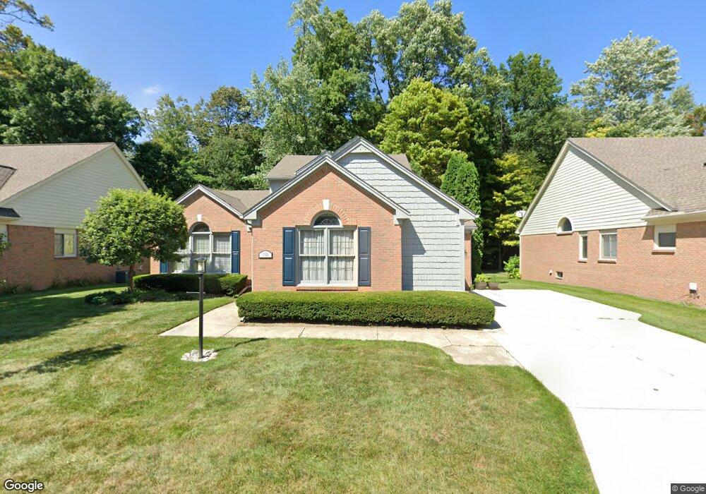
1106 Bluebird Dr Rochester Hills, MI 48307
Estimated Value: $347,000 - $531,000
3
Beds
3
Baths
2,335
Sq Ft
$197/Sq Ft
Est. Value
About This Home
This home is located at 1106 Bluebird Dr, Rochester Hills, MI 48307 and is currently estimated at $459,379, approximately $196 per square foot. 1106 Bluebird Dr is a home located in Oakland County with nearby schools including Brooklands Elementary School, Reuther Middle School, and Rochester High School.
Ownership History
Date
Name
Owned For
Owner Type
Purchase Details
Closed on
Mar 25, 2016
Sold by
Schassburger Gregory and Schassbuger Family Trust
Bought by
Kim Jacob Chol Kyu
Current Estimated Value
Purchase Details
Closed on
May 26, 2011
Sold by
Schassburger Frederick M and Schassburger Olive E
Bought by
Schassburger Frederick M and Schassburger Olive E
Home Financials for this Owner
Home Financials are based on the most recent Mortgage that was taken out on this home.
Original Mortgage
$158,200
Interest Rate
5.03%
Mortgage Type
New Conventional
Purchase Details
Closed on
May 28, 1996
Sold by
Collins Richard J
Bought by
Schassburger Frederick M
Home Financials for this Owner
Home Financials are based on the most recent Mortgage that was taken out on this home.
Original Mortgage
$110,000
Interest Rate
8.05%
Create a Home Valuation Report for This Property
The Home Valuation Report is an in-depth analysis detailing your home's value as well as a comparison with similar homes in the area
Home Values in the Area
Average Home Value in this Area
Purchase History
| Date | Buyer | Sale Price | Title Company |
|---|---|---|---|
| Kim Jacob Chol Kyu | $169,000 | None Available | |
| Schassburger Frederick M | -- | None Available | |
| Schassburger Frederick M | $231,500 | -- |
Source: Public Records
Mortgage History
| Date | Status | Borrower | Loan Amount |
|---|---|---|---|
| Previous Owner | Schassburger Frederick M | $158,200 | |
| Previous Owner | Schassburger Frederick M | $110,000 |
Source: Public Records
Tax History Compared to Growth
Tax History
| Year | Tax Paid | Tax Assessment Tax Assessment Total Assessment is a certain percentage of the fair market value that is determined by local assessors to be the total taxable value of land and additions on the property. | Land | Improvement |
|---|---|---|---|---|
| 2022 | $2,080 | $184,820 | $0 | $0 |
| 2018 | $3,447 | $153,060 | $0 | $0 |
| 2017 | $3,458 | $148,630 | $0 | $0 |
| 2015 | -- | $136,340 | $0 | $0 |
| 2014 | -- | $120,310 | $0 | $0 |
| 2011 | -- | $112,020 | $0 | $0 |
Source: Public Records
Map
Nearby Homes
- 1166 Sugar Creek Dr
- 980 Briston Dr
- 2082 Avon Lake Ln
- 2574 Culbertson Ave
- 2460 Emmons Ave
- 2025 Somerville
- 2333 Longview Ave
- 830 Dartmouth Dr
- 2198 London Bridge Dr
- 1480 E Hamlin Rd
- 513 Tennyson
- 2580 Longview Ave
- 2182 London Bridge Dr Unit G38
- 2162 London Bridge Dr Unit 56
- 535 Tennyson Unit 48
- 587 Tennyson
- 653 Glasgow Ct Unit 207
- 733 Hamilton Ct Unit 120
- 740 Eastbridge Ct
- 525 Oxford Ct
- 1118 Bluebird Dr
- 1094 Bluebird Dr Unit 29
- 1130 Bluebird Dr
- 1130 Bluebird Dr Unit 26
- 1103 Bluebird Dr Unit 52
- 1115 Bluebird Dr Unit 51
- 1091 Bluebird Dr
- 1127 Bluebird Dr
- 1142 Bluebird Dr
- 1082 Bluebird Dr
- 1139 Bluebird Dr Unit 49
- 1139 Bluebird Dr
- 1154 Bluebird Dr
- 1154 Bluebird Dr Unit 24
- 1104 Loncar Dr Unit 57
- 1116 Loncar Dr Unit 58
- 1116 Loncar Dr
- 1059 Bluebird Dr Unit 54
- 1070 Bluebird Dr Unit 31
- 1092 Loncar Dr Unit 56