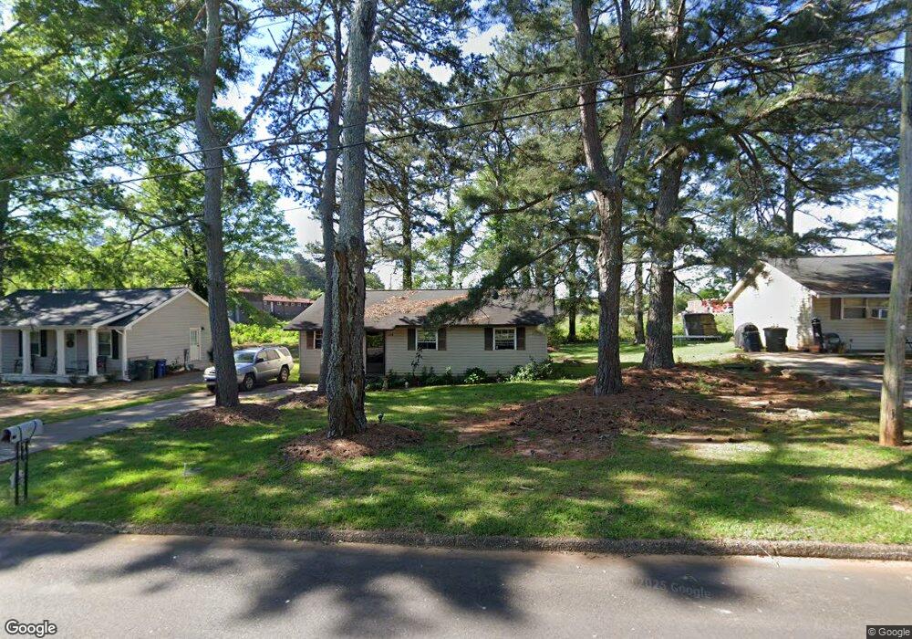
1106 Briarcliff St Griffin, GA 30224
Spalding County NeighborhoodEstimated Value: $91,227 - $144,000
--
Bed
1
Bath
950
Sq Ft
$131/Sq Ft
Est. Value
About This Home
This home is located at 1106 Briarcliff St, Griffin, GA 30224 and is currently estimated at $124,057, approximately $130 per square foot. 1106 Briarcliff St is a home located in Spalding County with nearby schools including Anne Street Elementary School, Rehoboth Road Middle School, and Griffin High School.
Ownership History
Date
Name
Owned For
Owner Type
Purchase Details
Closed on
Jan 15, 1993
Sold by
Pip Inc
Bought by
Ferguson Grover
Current Estimated Value
Purchase Details
Closed on
May 10, 1983
Sold by
Commercial Bank & Trust Co
Bought by
Pip Inc
Purchase Details
Closed on
Jan 4, 1978
Sold by
Collier J Taylor
Bought by
Commercial Bank & Trust Co
Purchase Details
Closed on
Jun 16, 1971
Sold by
Nichols Vivian C
Bought by
Collier J Taylor
Purchase Details
Closed on
Feb 5, 1971
Sold by
Nichols Jefferson D
Bought by
Nichols Vivian C
Create a Home Valuation Report for This Property
The Home Valuation Report is an in-depth analysis detailing your home's value as well as a comparison with similar homes in the area
Home Values in the Area
Average Home Value in this Area
Purchase History
| Date | Buyer | Sale Price | Title Company |
|---|---|---|---|
| Ferguson Grover | $92,400 | -- | |
| Pip Inc | $12,500 | -- | |
| Commercial Bank & Trust Co | -- | -- | |
| Collier J Taylor | $54,000 | -- | |
| Nichols Vivian C | -- | -- |
Source: Public Records
Tax History Compared to Growth
Tax History
| Year | Tax Paid | Tax Assessment Tax Assessment Total Assessment is a certain percentage of the fair market value that is determined by local assessors to be the total taxable value of land and additions on the property. | Land | Improvement |
|---|---|---|---|---|
| 2024 | $755 | $20,215 | $5,120 | $15,095 |
| 2023 | $772 | $20,215 | $5,120 | $15,095 |
| 2022 | $643 | $16,086 | $3,200 | $12,886 |
| 2021 | $539 | $13,484 | $2,000 | $11,484 |
| 2020 | $504 | $12,608 | $2,560 | $10,048 |
| 2019 | $355 | $8,726 | $2,432 | $6,294 |
| 2018 | $338 | $7,994 | $2,432 | $5,562 |
| 2017 | $330 | $7,994 | $2,432 | $5,562 |
| 2016 | $336 | $7,994 | $2,432 | $5,562 |
| 2015 | $341 | $7,994 | $2,432 | $5,562 |
| 2014 | $352 | $7,994 | $2,432 | $5,562 |
Source: Public Records
Map
Nearby Homes
- 825 Pamela Dr
- 1022 Beck St
- 731 Scales St
- 717 Scales St
- 821 Booker St
- 1326 Oakdale Dr
- 1228-1328 Edgewood Ave
- 220 Airport Rd
- 236 Airport Rd
- 1541 Zebulon Rd & Unit 4 TRACTS 35 ACRES
- 1012 W College Extension
- 1313 D F Fuller Dr
- TRACT B Zebulon Rd
- 201 Laramie Rd
- 202 Hillandale Dr
- 106 Summit Dr
- 112 Oak Ave SW
- 305 S 18th St
- 1320 N Cherokee Ave
- 115 Kennelsman Dr Unit LOT FC 1
- 1108 Briarcliff St
- 1104 Briarcliff St
- 1110 Briarcliff St
- 1102 Briarcliff St
- 1115 Anne St
- 1105 Briarcliff St
- 1103 Briarcliff St
- 1112 Briarcliff St
- 1107 Anne St
- 1107 Briarcliff St
- 1101 Briarcliff St
- 1109 Briarcliff St
- 1114 Briarcliff St
- 1111 Briarcliff St
- 924 Anne St
- 922 Anne St
- 920 Anne St
- 1002 Anne St
- 1116 Briarcliff St
- 1113 Briarcliff St