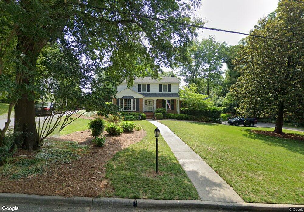
1106 Rockford Rd High Point, NC 27262
Greater High Point NeighborhoodEstimated Value: $422,990 - $623,000
4
Beds
3
Baths
2,502
Sq Ft
$208/Sq Ft
Est. Value
About This Home
This home is located at 1106 Rockford Rd, High Point, NC 27262 and is currently estimated at $520,998, approximately $208 per square foot. 1106 Rockford Rd is a home located in Guilford County with nearby schools including Northwood Elementary School, Ferndale Middle School, and High Point Central High School.
Ownership History
Date
Name
Owned For
Owner Type
Purchase Details
Closed on
May 17, 2005
Sold by
Williams James A and Williams Ashley W
Bought by
Keever Wesley R and Keever Mary
Current Estimated Value
Home Financials for this Owner
Home Financials are based on the most recent Mortgage that was taken out on this home.
Original Mortgage
$50,000
Outstanding Balance
$25,903
Interest Rate
5.74%
Mortgage Type
Credit Line Revolving
Estimated Equity
$495,095
Purchase Details
Closed on
Jun 11, 2001
Sold by
Lewis Craig Steven and Morris Patricia L
Bought by
Williams James A and Williams Ashley W
Home Financials for this Owner
Home Financials are based on the most recent Mortgage that was taken out on this home.
Original Mortgage
$204,000
Interest Rate
7.11%
Create a Home Valuation Report for This Property
The Home Valuation Report is an in-depth analysis detailing your home's value as well as a comparison with similar homes in the area
Home Values in the Area
Average Home Value in this Area
Purchase History
| Date | Buyer | Sale Price | Title Company |
|---|---|---|---|
| Keever Wesley R | $285,000 | -- | |
| Williams James A | $255,000 | -- |
Source: Public Records
Mortgage History
| Date | Status | Borrower | Loan Amount |
|---|---|---|---|
| Open | Keever Wesley R | $50,000 | |
| Open | Keever Wesley R | $206,500 | |
| Previous Owner | Williams James A | $204,000 | |
| Closed | Williams James A | $38,250 |
Source: Public Records
Tax History Compared to Growth
Tax History
| Year | Tax Paid | Tax Assessment Tax Assessment Total Assessment is a certain percentage of the fair market value that is determined by local assessors to be the total taxable value of land and additions on the property. | Land | Improvement |
|---|---|---|---|---|
| 2025 | $4,856 | $352,400 | $77,000 | $275,400 |
| 2024 | $4,856 | $352,400 | $77,000 | $275,400 |
| 2023 | $4,856 | $352,400 | $77,000 | $275,400 |
| 2022 | $4,750 | $352,400 | $77,000 | $275,400 |
| 2021 | $4,319 | $313,400 | $75,000 | $238,400 |
| 2020 | $4,319 | $313,400 | $75,000 | $238,400 |
| 2019 | $4,319 | $313,400 | $0 | $0 |
| 2018 | $4,297 | $313,400 | $0 | $0 |
| 2017 | $4,297 | $313,400 | $0 | $0 |
| 2016 | $4,158 | $296,500 | $0 | $0 |
| 2015 | $4,181 | $296,500 | $0 | $0 |
| 2014 | $4,252 | $296,500 | $0 | $0 |
Source: Public Records
Map
Nearby Homes
- 1228 Dovershire Place
- 1232 Dovershire Place
- 1042 Rockford Rd
- 1122 Kensington Dr
- 1307 Hempshire Ct
- 427 Woodbrook Dr
- 1408 Wales Dr
- 510 Otteray Ave
- 1116 Ferndale Blvd
- 1304 Wickliff Ave
- 407 Emerywood Dr
- 1007 N Rotary Dr
- 416 W Lexington Ave
- 1319 Robin Hood Rd
- 824 W Lexington Ave
- 300 Edgedale Dr
- 1408 1410 Westchester Dr
- 1011 Ferndale Blvd
- 1200 Devlin Ct
- 605 Westchester Dr
- 1108 Rockford Rd
- 1104 Rockford Rd
- 803 Country Club Dr
- 805 Country Club Dr
- 1110 Rockford Rd
- 1111 Rockford Rd
- 801 Country Club Dr
- 1100 Rockford Rd
- 1107 Rockford Rd
- 1112 Rockford Rd
- 809 Country Club Dr
- 1113 Rockford Rd
- 1115 Rockford Rd
- 811 Country Club Dr
- 1101 Rockford Rd
- 1117 Rockford Rd
- 1300 Providence Ave
- 1050 Rockford Rd
- 1218 Dovershire Place
- 1201 Glenwick Ln Unit Lot B