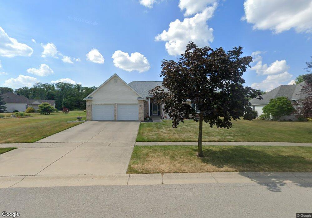
1107 Arrowhead Trail Wauseon, OH 43567
Estimated Value: $340,505 - $407,000
3
Beds
2
Baths
2,058
Sq Ft
$180/Sq Ft
Est. Value
About This Home
This home is located at 1107 Arrowhead Trail, Wauseon, OH 43567 and is currently estimated at $371,376, approximately $180 per square foot. 1107 Arrowhead Trail is a home located in Fulton County with nearby schools including Wauseon Primary School, Wauseon Elementary School, and Wauseon Middle School.
Ownership History
Date
Name
Owned For
Owner Type
Purchase Details
Closed on
Jul 5, 2005
Sold by
Unterbrink Leon R and Unterbrink Mary L
Bought by
Bascom Randall C and Bascom Lou Ann
Current Estimated Value
Home Financials for this Owner
Home Financials are based on the most recent Mortgage that was taken out on this home.
Original Mortgage
$105,000
Interest Rate
5.86%
Mortgage Type
Fannie Mae Freddie Mac
Purchase Details
Closed on
Jul 1, 1996
Sold by
Brenner Properties
Bought by
Smiarowski Mary L
Create a Home Valuation Report for This Property
The Home Valuation Report is an in-depth analysis detailing your home's value as well as a comparison with similar homes in the area
Home Values in the Area
Average Home Value in this Area
Purchase History
| Date | Buyer | Sale Price | Title Company |
|---|---|---|---|
| Bascom Randall C | $211,500 | -- | |
| Smiarowski Mary L | $23,900 | -- |
Source: Public Records
Mortgage History
| Date | Status | Borrower | Loan Amount |
|---|---|---|---|
| Closed | Bascom Randall C | $105,000 |
Source: Public Records
Tax History
| Year | Tax Paid | Tax Assessment Tax Assessment Total Assessment is a certain percentage of the fair market value that is determined by local assessors to be the total taxable value of land and additions on the property. | Land | Improvement |
|---|---|---|---|---|
| 2024 | $4,710 | $97,940 | $13,410 | $84,530 |
| 2023 | $4,870 | $97,940 | $13,410 | $84,530 |
| 2022 | $4,588 | $78,270 | $11,170 | $67,100 |
| 2021 | $4,814 | $78,270 | $11,170 | $67,100 |
| 2020 | $4,487 | $78,270 | $11,170 | $67,100 |
| 2019 | $3,927 | $67,450 | $11,170 | $56,280 |
| 2018 | $3,489 | $67,450 | $11,170 | $56,280 |
| 2017 | $3,441 | $67,450 | $11,170 | $56,280 |
| 2016 | $3,397 | $60,140 | $11,170 | $48,970 |
| 2015 | $3,191 | $60,140 | $11,170 | $48,970 |
| 2014 | $3,026 | $60,140 | $11,170 | $48,970 |
| 2013 | $3,551 | $65,140 | $11,620 | $53,520 |
Source: Public Records
Map
Nearby Homes
- 1171 Apache Dr
- 1090 Seneca Dr
- 1062 Seneca Dr
- 1066 Seneca Dr
- 840 Pine St
- 13242 Us Highway 20a
- 760 Airport Hwy
- 351 E Walnut St
- 460 Airport Hwy
- 833 3rd St
- 203 E Oak St
- 7373 County Road 12
- 14578 Us Highway 20a
- 1338 N Park Ln
- 252 W Chestnut St
- 239 W Chestnut St
- 263 W Chestnut St
- 11470 County Rd E
- 420 Clover Ln
- 594 Douglas Dr
- 1111 Arrowhead Trail
- 1103 Arrowhead Trail
- 1160 Apache Dr
- 1115 Arrowhead Trail
- 1116 Arrowhead Trail
- 1164 Apache Dr Lot 17
- 1164 Apache Drive Lot 17
- 1119 Arrowhead Trail
- 1164 Apache Dr
- 1065 Arrowhead Trail
- 1112 Arrowhead Trail
- 1120 Arrowhead Trail
- 1123 Arrowhead Trail #24
- 1123 Arrowhead Trail
- 1240 Apache Dr
- 1108 Arrowhead Trail
- 75 Apache Dr
- 74 Apache Dr
- 72 Apache Dr
- 80 Apache Dr
Your Personal Tour Guide
Ask me questions while you tour the home.