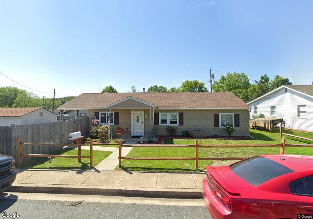
1107 Cord St Middle River, MD 21220
Estimated Value: $209,000 - $262,000
--
Bed
1
Bath
1,216
Sq Ft
$191/Sq Ft
Est. Value
About This Home
This home is located at 1107 Cord St, Middle River, MD 21220 and is currently estimated at $232,511, approximately $191 per square foot. 1107 Cord St is a home located in Baltimore County with nearby schools including Orems Elementary, Stemmers Run Middle School, and Kenwood High.
Ownership History
Date
Name
Owned For
Owner Type
Purchase Details
Closed on
Feb 7, 2002
Sold by
Kearney William Marshall
Bought by
Beckman Joseph G and Beckman Eva M
Current Estimated Value
Purchase Details
Closed on
Sep 15, 1993
Sold by
Agostinelli M M
Bought by
Kearney William M
Home Financials for this Owner
Home Financials are based on the most recent Mortgage that was taken out on this home.
Original Mortgage
$75,600
Interest Rate
7.16%
Create a Home Valuation Report for This Property
The Home Valuation Report is an in-depth analysis detailing your home's value as well as a comparison with similar homes in the area
Home Values in the Area
Average Home Value in this Area
Purchase History
| Date | Buyer | Sale Price | Title Company |
|---|---|---|---|
| Beckman Joseph G | $80,000 | -- | |
| Kearney William M | $84,000 | -- | |
| Agostinelli Michael M | $66,000 | -- |
Source: Public Records
Mortgage History
| Date | Status | Borrower | Loan Amount |
|---|---|---|---|
| Previous Owner | Agostinelli Michael M | $75,600 |
Source: Public Records
Tax History Compared to Growth
Tax History
| Year | Tax Paid | Tax Assessment Tax Assessment Total Assessment is a certain percentage of the fair market value that is determined by local assessors to be the total taxable value of land and additions on the property. | Land | Improvement |
|---|---|---|---|---|
| 2025 | $2,912 | $181,600 | -- | -- |
| 2024 | $2,912 | $171,200 | $0 | $0 |
| 2023 | $1,349 | $160,800 | $53,700 | $107,100 |
| 2022 | $2,690 | $151,167 | $0 | $0 |
| 2021 | $2,479 | $141,533 | $0 | $0 |
| 2020 | $2,479 | $131,900 | $53,700 | $78,200 |
| 2019 | $2,414 | $131,233 | $0 | $0 |
| 2018 | $2,387 | $130,567 | $0 | $0 |
| 2017 | $2,264 | $129,900 | $0 | $0 |
| 2016 | $1,871 | $127,800 | $0 | $0 |
| 2015 | $1,871 | $125,700 | $0 | $0 |
| 2014 | $1,871 | $123,600 | $0 | $0 |
Source: Public Records
Map
Nearby Homes
- 1100 Cord St
- 1013 Cord St
- 44 Left Wing Dr
- 15 Gyro Dr
- 1008 Fuselage Ave
- 53 Longeron Dr
- 110 Judywood Ln
- 6 Gyro Dr
- 109 Judywood Ln
- 35 Rockywood Ln
- 61 Rockywood Ln
- 110 Compass Rd
- 16 Yawmeter Dr
- 94 Ginwood Ln
- 958 Arncliffe Rd
- 909 Arncliffe Rd
- 910 N Marlyn Ave
- 844 N Marlyn Ave
- 832 N Marlyn Ave
- 1335 Canberra Dr