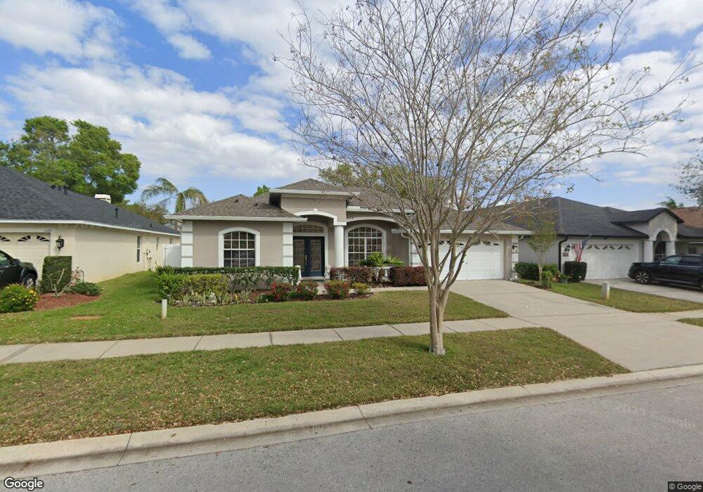
1107 Lumsden Pointe Blvd Valrico, FL 33594
Estimated Value: $415,569 - $518,000
4
Beds
3
Baths
2,320
Sq Ft
$208/Sq Ft
Est. Value
About This Home
This home is located at 1107 Lumsden Pointe Blvd, Valrico, FL 33594 and is currently estimated at $481,642, approximately $207 per square foot. 1107 Lumsden Pointe Blvd is a home located in Hillsborough County with nearby schools including Brooker Elementary School, Burns Middle School, and Bloomingdale High School.
Ownership History
Date
Name
Owned For
Owner Type
Purchase Details
Closed on
Apr 29, 2003
Sold by
Westfield Homes Of Florida Inc
Bought by
Ng Cheong S and Ng Ginny T
Current Estimated Value
Home Financials for this Owner
Home Financials are based on the most recent Mortgage that was taken out on this home.
Original Mortgage
$147,446
Outstanding Balance
$61,341
Interest Rate
5.68%
Mortgage Type
Unknown
Estimated Equity
$420,301
Purchase Details
Closed on
Jul 2, 2002
Sold by
Transcend Dev Corp C
Bought by
Westfield Homes Of Florida
Create a Home Valuation Report for This Property
The Home Valuation Report is an in-depth analysis detailing your home's value as well as a comparison with similar homes in the area
Home Values in the Area
Average Home Value in this Area
Purchase History
| Date | Buyer | Sale Price | Title Company |
|---|---|---|---|
| Ng Cheong S | $187,500 | Alday Donalson Title Agencie | |
| Westfield Homes Of Florida | $194,700 | -- |
Source: Public Records
Mortgage History
| Date | Status | Borrower | Loan Amount |
|---|---|---|---|
| Open | Ng Cheong S | $147,446 |
Source: Public Records
Tax History
| Year | Tax Paid | Tax Assessment Tax Assessment Total Assessment is a certain percentage of the fair market value that is determined by local assessors to be the total taxable value of land and additions on the property. | Land | Improvement |
|---|---|---|---|---|
| 2025 | $2,960 | $178,258 | -- | -- |
| 2024 | $2,960 | $173,234 | -- | -- |
| 2023 | $2,839 | $168,188 | $0 | $0 |
| 2022 | $2,699 | $163,289 | $0 | $0 |
| 2021 | $2,930 | $158,533 | $0 | $0 |
| 2020 | $2,845 | $156,344 | $0 | $0 |
| 2019 | $2,749 | $152,829 | $0 | $0 |
| 2018 | $2,695 | $149,979 | $0 | $0 |
| 2017 | $2,657 | $203,628 | $0 | $0 |
| 2016 | $2,611 | $143,873 | $0 | $0 |
| 2015 | $2,634 | $142,873 | $0 | $0 |
| 2014 | $2,554 | $141,739 | $0 | $0 |
| 2013 | -- | $139,644 | $0 | $0 |
Source: Public Records
Map
Nearby Homes
- 2010 Lee Dr
- 1539 Highcrest Cir
- 2003 Leichester St
- 1734 Powder Ridge Dr
- 1813 Nova Dr
- 811 Sandcastle Cir
- 1111 Durant Rd
- 544 Royal Ridge St
- 950 Terra Vista St
- 823 Floresta St
- 1032 Legends Pass Dr
- 1106 Hummingbird Ln
- 1618 Citrus Orchard Way
- 1023 Legends Pass Dr
- 828 Innergary Place
- 510 Third St
- 517 Royal Ridge St
- 829 Innergary Place
- 506 Third St
- 404 Regal Park Dr
- 1109 Lumsden Pointe Blvd
- 1105 Lumsden Pointe Blvd
- 1111 Lumsden Pointe Blvd
- 1108 Split Silk St
- 1106 Split Silk St
- 1103 Lumsden Pointe Blvd
- 1110 Split Silk St
- 1113 Lumsden Pointe Blvd
- 1106 Lumsden Pointe Blvd
- 1104 Split Silk St
- 1104 Lumsden Pointe Blvd
- 1112 Lumsden Pointe Blvd
- 1112 Split Silk St
- 1115 Lumsden Pointe Blvd
- 1102 Lumsden Pointe Blvd
- 1114 Lumsden Pointe Blvd
- 1901 Burridge Ct
- 1117 Lumsden Pointe Blvd
- 1114 Split Silk St
- 1903 Burridge Ct