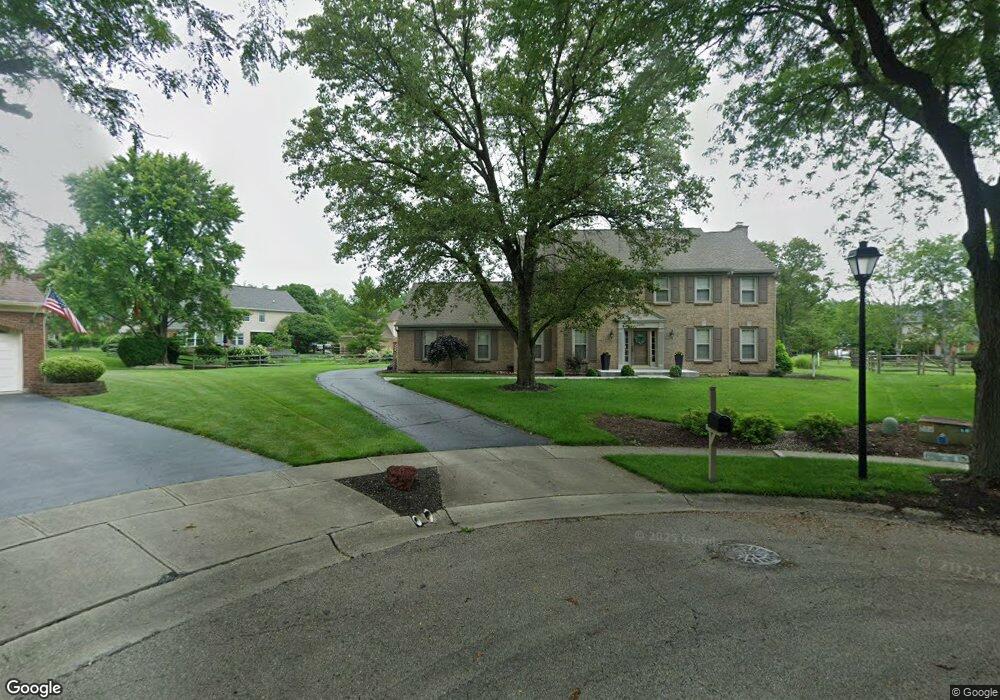
11070 Dellbrook Ct Cincinnati, OH 45241
Estimated Value: $471,102 - $581,000
4
Beds
3
Baths
3,409
Sq Ft
$156/Sq Ft
Est. Value
About This Home
This home is located at 11070 Dellbrook Ct, Cincinnati, OH 45241 and is currently estimated at $533,026, approximately $156 per square foot. 11070 Dellbrook Ct is a home located in Hamilton County with nearby schools including Sharonville Elementary School, Princeton Community Middle School, and Princeton High School.
Ownership History
Date
Name
Owned For
Owner Type
Purchase Details
Closed on
May 29, 2015
Sold by
Gail Susan
Bought by
Wood Richard P and Wood Lindsay H
Current Estimated Value
Home Financials for this Owner
Home Financials are based on the most recent Mortgage that was taken out on this home.
Original Mortgage
$226,400
Interest Rate
3.65%
Mortgage Type
New Conventional
Purchase Details
Closed on
Jun 3, 2002
Sold by
Moore Michael and Moore Susan
Bought by
Moore Susan
Purchase Details
Closed on
Apr 24, 2002
Sold by
Moore Susan and Moore Susan G
Bought by
Moore Susan Gail and The Susan Gail Moore Family Trust
Purchase Details
Closed on
Nov 26, 2001
Sold by
Moore Michael and Moore Michael E
Bought by
Moore Susan and Moore Susan G
Create a Home Valuation Report for This Property
The Home Valuation Report is an in-depth analysis detailing your home's value as well as a comparison with similar homes in the area
Home Values in the Area
Average Home Value in this Area
Purchase History
| Date | Buyer | Sale Price | Title Company |
|---|---|---|---|
| Wood Richard P | $283,000 | Attorney | |
| Moore Susan | -- | -- | |
| Moore Susan Gail | -- | -- | |
| Moore Susan | -- | -- |
Source: Public Records
Mortgage History
| Date | Status | Borrower | Loan Amount |
|---|---|---|---|
| Previous Owner | Wood Richard P | $226,400 |
Source: Public Records
Tax History Compared to Growth
Tax History
| Year | Tax Paid | Tax Assessment Tax Assessment Total Assessment is a certain percentage of the fair market value that is determined by local assessors to be the total taxable value of land and additions on the property. | Land | Improvement |
|---|---|---|---|---|
| 2024 | $4,845 | $119,396 | $19,075 | $100,321 |
| 2023 | $4,849 | $119,396 | $19,075 | $100,321 |
| 2022 | $5,455 | $107,968 | $18,886 | $89,082 |
| 2021 | $5,303 | $107,968 | $18,886 | $89,082 |
| 2020 | $5,365 | $107,968 | $18,886 | $89,082 |
| 2019 | $5,351 | $99,050 | $17,325 | $81,725 |
| 2018 | $5,019 | $99,050 | $17,325 | $81,725 |
| 2017 | $4,700 | $99,050 | $17,325 | $81,725 |
| 2016 | $4,390 | $91,750 | $16,853 | $74,897 |
| 2015 | $4,433 | $91,750 | $16,853 | $74,897 |
| 2014 | $4,447 | $91,750 | $16,853 | $74,897 |
| 2013 | $4,060 | $85,747 | $15,750 | $69,997 |
Source: Public Records
Map
Nearby Homes
- 4170 Cornell Rd
- 11220 Foremark Dr
- 4420 Cornell Rd
- 11192 Jardin Place
- 10914 Lemarie Dr
- 10823 Willfleet Dr
- 10775 Lemarie Dr
- 4086 Retreat Dr
- 3706 Verbena Dr
- 10788 Thornview Dr
- 4051 Beavercreek Cir
- 10912 Aztec Ct
- 4254 Fox Hollow Dr
- 4071 E Kemper Rd
- Lexington Plan at Chimney Ridge
- Vaquero Plan at Chimney Ridge
- 3380 Spurrier Ln
- 3592 Horncastle Dr
- 3756 Glendale Milford Rd
- 11117 Kemper Ave
- 11064 Dellbrook Ct
- 4127 Benkert Dr
- 4121 Benkert Dr
- 4133 Benkert Dr
- 11071 Dellbrook Ct
- 4138 Malaer Dr
- 4115 Benkert Dr
- 4132 Malaer Dr
- 11058 Dellbrook Ct
- 11065 Dellbrook Ct
- 4139 Benkert Dr
- 4109 Benkert Dr
- 4144 Malaer Dr
- 4126 Malaer Dr
- 4114 Malaer Dr
- 4108 Benkert Dr
- 4102 Benkert Dr
- 4096 Benkert Dr
- 4103 Benkert Dr
- 4108 Malaer Dr