Estimated Value: $156,000 - $232,000
3
Beds
2
Baths
1,873
Sq Ft
$98/Sq Ft
Est. Value
About This Home
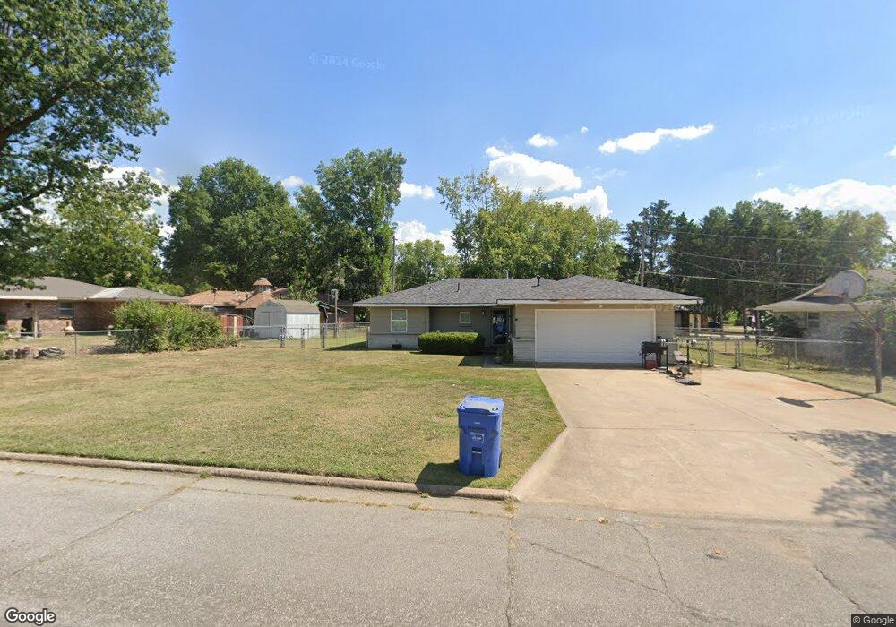
This home is located at 1108 16th Ave NE, Miami, OK 74354 and is currently estimated at $183,230, approximately $97 per square foot. 1108 16th Ave NE is a home located in Ottawa County with nearby schools including Miami High School and Mt. Olive Lutheran School.
Ownership History
Date
Name
Owned For
Owner Type
Purchase Details
Closed on
Sep 12, 2011
Sold by
Hessee Jennifer L
Bought by
Mccorkell Ronald C
Current Estimated Value
Purchase Details
Closed on
Jun 10, 2008
Sold by
Hessee Michael Todd
Bought by
Hessee Jennifer L
Home Financials for this Owner
Home Financials are based on the most recent Mortgage that was taken out on this home.
Original Mortgage
$80,000
Interest Rate
6.07%
Mortgage Type
New Conventional
Purchase Details
Closed on
Feb 14, 1997
Bought by
Hessee Michael Todd
Purchase Details
Closed on
Sep 23, 1994
Bought by
Schliep Ronald D
Create a Home Valuation Report for This Property
The Home Valuation Report is an in-depth analysis detailing your home's value as well as a comparison with similar homes in the area
Home Values in the Area
Average Home Value in this Area
Purchase History
| Date | Buyer | Sale Price | Title Company |
|---|---|---|---|
| Mccorkell Ronald C | $3,000 | Ottawa County Abstract & Tit | |
| Hessee Jennifer L | -- | None Available | |
| Hessee Michael Todd | $66,000 | -- | |
| Schliep Ronald D | -- | -- |
Source: Public Records
Mortgage History
| Date | Status | Borrower | Loan Amount |
|---|---|---|---|
| Previous Owner | Hessee Jennifer L | $80,000 |
Source: Public Records
Tax History Compared to Growth
Tax History
| Year | Tax Paid | Tax Assessment Tax Assessment Total Assessment is a certain percentage of the fair market value that is determined by local assessors to be the total taxable value of land and additions on the property. | Land | Improvement |
|---|---|---|---|---|
| 2025 | $719 | $7,830 | $503 | $7,327 |
| 2024 | $719 | $7,457 | $479 | $6,978 |
| 2023 | $719 | $7,102 | $453 | $6,649 |
| 2022 | $625 | $6,763 | $428 | $6,335 |
| 2021 | $609 | $6,442 | $405 | $6,037 |
| 2020 | $585 | $6,135 | $382 | $5,753 |
| 2019 | $480 | $5,843 | $347 | $5,496 |
| 2018 | $460 | $5,565 | $326 | $5,239 |
| 2017 | $445 | $5,300 | $305 | $4,995 |
| 2016 | $405 | $5,047 | $285 | $4,762 |
| 2015 | $514 | $5,784 | $798 | $4,986 |
| 2014 | $394 | $4,807 | $265 | $4,542 |
Source: Public Records
Map
Nearby Homes
- 1611 Woodlawn Dr
- 1215 Sky Ln
- 1934 Birnamwood Dr
- 1803 Washington Dr
- 1644 D St NE
- 2101 Birnamwood Dr
- 1815 N Grant Pkwy
- 1518 Lincoln Blvd
- 1839 D St NE
- 1821 C St NE
- 1928 Cleveland Ave
- 1916 S Grant Pkwy
- 411 E Bj Tunnell Blvd
- 1300 Maple Dr
- 624 G St NE
- 2003 E Rockdale Rd
- 2014 Harvard Ave
- 1916 A St NE
- 718 N Elm St
- 601 G St NE
- 1102 16th Ave NE
- 1415 Carol Ct
- 1101 16th Ave NE
- 1508 Ponder Ct
- 1409 Carol Ct
- 1417 Carol Ct
- 1025 Sky Harbor Dr
- 1512 Ponder Ct
- 1516 Ponder Ct
- 1111 16th Ave NE
- 1024 Sky Harbor Dr
- 1502 Ponder Ct
- 1412 Carol Ct
- 1408 Carol Ct
- 1012 Sky Harbor Dr
- 1032 16th Ave NE
- 1015 Sky Harbor Dr
- 1416 Carol Ct
- 1517 Ponder Ct
- 1020 16th Ave NE